
16.10.13. Mona Vale front gate sign, Wairarapa Stream, Fendalton Rd
Mona Vale focus. Fendalton Rd: Wednesday 16.10.13. I hadn't seen Mona Vale since the 4 September 2010 Quake, so it was time for another look. Mona Vale was a Council park at a four river confluence: Wairarapa Steam, Waimairi Stream, Avon River, Mill Stream. A railway / trashed brick wall was one side of Mona Vale, housing was on the other side of the river. Mona Vale started as Victorian private property taken over by Council in the 1960s. NZ Historic Places Trust listed Mona Vale as Category 1 Historic Place, ratepayers paid for upkeep & damages.

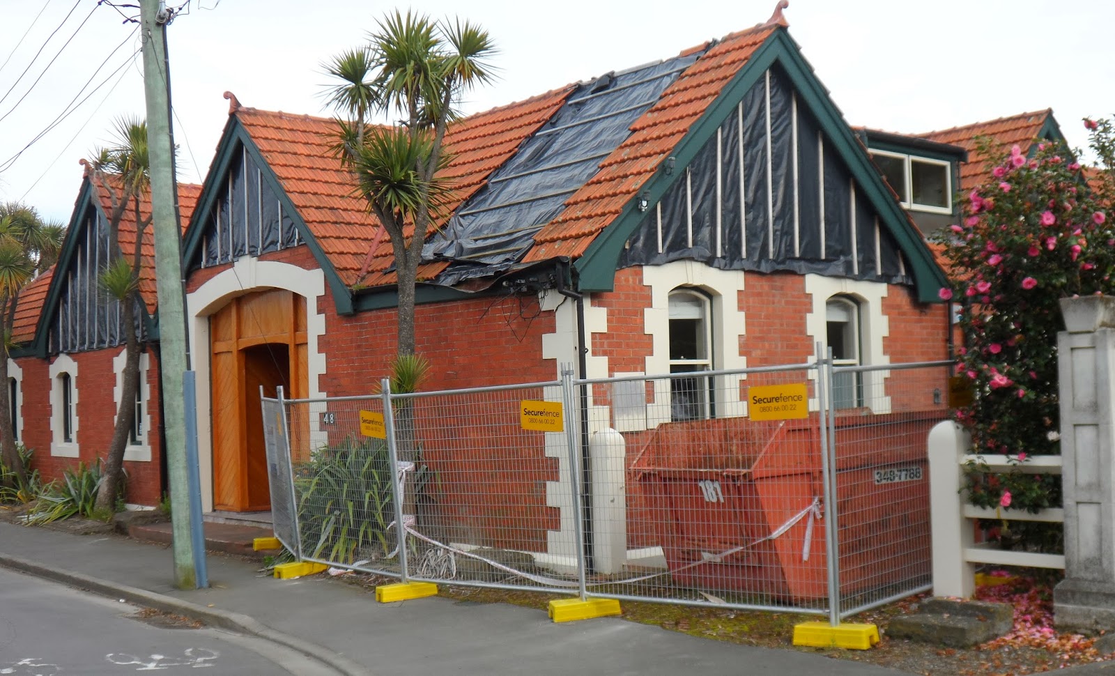
16.10.13. Quake trashed, abandoned Mona Vale gate house, Fendalton Rd. The gate house would be repaired, 2016


16.10.13. City Care workmen clearing water weed, Wairarapa Stream, Mona Vale, Fendalton Rd

Heritage-hailers squawked when post-quake demolitions were imminent, but did little fund-raising to protect heritage buildings. So damaged, heritage buildings just stood empty & SMF-cordoned.


16.10.13. Steel mesh fence cordon. Quake trashed, abandoned Mona Vale gate house, Fendalton Rd. The gate house would be repaired, 2016


Fendalton Rd: By the railway, I looked at Mona Vale's gate-house which was SMF-cordoned since the 22 February 2011 Quake. A fallen chimney still lay on the footpath, metal sheeting covered two parts of the roof where two chimneys had collapsed. Walls were cracked & boarded.
The gate-house would be repaired, 2016.

16.10.13. Steel mesh fence cordon. Quake trashed, abandoned Mona Vale gate house, Fendalton Rd. The gate house would be repaired, 2016


On a SMF-cordon, a Council information-board:
This Christchurch City Council facility is closed due to earthquakes.
The Council is striving to assess and carry out work on its 1600 buildings as quickly as possible as part of its Facilities Rebuild Plan Programme...

16.10.13. Wairarapa Stream, Waimari Stream, Avon River confluence, Mona Vale


I crossed a couple of wooden-bridges where Waimairi Stream & Avon River joined Wairarapa Stream. Leah liked feeding ducks there, a peaceful place away from Fendalton Rd.
By the carpark a lengthy section of garden brick-wall bordering the railway had collapsed, rubble lying alongside the broken-wall. Past the rose garden towards the fernery, I saw more sections of the collapsed brick-wall. More rubble lay alongside.

16.10.13. Quake collapsed brick wall, Avon River, Mona Vale


16.10.13. Quake collapsed brick wall between railway & Mona Vale carpark


16.10.13. Steel mesh fence cordon. Quake collapsed brick wall, Mona Vale fernery

The abandoned homestead / restaurant was SMF-cordoned since the 2010-11 quakes, propped by wood-bracing & steel-bracing & big concrete- blocks on two sides. Many windows of the two-storey house were boarded. A large section of the front wall was covered in black plastic.

16.10.13. Steel mesh fence cordon. Quake trashed, abandoned Mona Vale homestead / restaurant


On another SMF-cordon, another Council information-board:
The Homestead
Mona Vale
The building was damaged in the 2010/11 Canterbury earthquakes and aftershocks.
Propping walls and other support is designed to keep the building weather-proof [stopped collapse] until a decision about its future can be made.
The English arts and crafts movement influenced the design of the homestead. It was built in 1897 for Frederick Waymouth manager of the region's frozen meat works. Heiress Annie Townend purchased the property in 1905 renaming it Mona Vale after her mother's birthplace in Tasmania.
New Zealand Historic Places Trust / Pouhere Toanga lists Mona Vale as a Category 1 Historic Place.

16.10.13. Steel mesh fence cordon. Quake trashed, abandoned Mona Vale homestead / restaurant


16.10.13. Quake closed, abandoned Bath House, Mona Vale


16.10.13. Mona Vale, Bath House view: Avon River
By Christchurch Girls HS sports ground, I saw another abandoned gate-house: boarded windows, black plastic / boarded roof damages, SMF- cordoned. Pre-quakes, Council had used that gate-house as a Botanical Services office. The garden was used as a nursery for park plants. A back-gate sign:
PRIVATE
RESIDENCE
PLEASE
KEEP OUT!

Only an idiot would enter that house! The front door was still green-stickered, March 2011, NO RESTRICTION ON USE OR OCCUPANCY... Another post-quake, rapid assessment cockup by Council!

16.10.13. Quake trashed, abandoned, Mona Vale office / gate house


16.10.13. Mona Vale back gate sign
Avon River rolled on. Five City Care workmen wearing orange Hi-vis vests waded the river while removing river-weed using long poles. Disturbed weeds floated downstream. I saw Botanical Services workmen weeding flower beds. School girls wandered to school & joggers jogged through the riverside park. The wrought-iron gazebo with copper-dome & stained-glass windows was undamaged by the quakes.

16.10.13. Wrought iron gazebo, Mona Vale


I trekked back to Burnside via Matai St West & Straven Rd past damaged housing & demolitions hidden by shrubbery & high walls. By the railway opposite Mona Vale on Matai St West corner, I saw a brick-clad ruin, black plastic covered its walls & gables. Further on I saw a two-storey, Oamaru whitestone house: broken garden-wall, cracked-chimney.

16.10.13. Steel mesh fence cordon. Quake abandoned house, Matai St West, by railway opp Mona Vale




16.10.13. Quake repairs, tradesman sign, Matai St West

16.10.13. Quake cracked, Oamaru whitestone chimney, Matai St West


16.10.13. Quake collapsed garden wall, Matai St West

16.10.13. Quake damaged, part repaired house, Matai St West

Straven Rd: Near Christchurch Boys HS:I saw several broken-houses where contractors did repairs: asphalters, roofers, painters... Those houses were built on swampland, as Waimairi Stream & Avon River flowed under Straven Rd to Mona Vale.

16.10.13. Christchurch Boys High, Straven Rd

16.10.13. Quake damaged war memorial, Christchurch BH, Straven Rd


16.10.13. Post quake house repair, Straven Rd


16.10.13. Quake collapsed, garden wall next to Avon River, Straven Rd

16.10.13. Avon River, Straven Rd

16.10.13. SOLD. Real estate sign, Straven Rd

16.10.13. Post quake house repair, Straven Rd

The new Council mayor Dalziel & her mostly new councillors could either maintain management weeds grown by Parker's & Marryatt's former Council, or clean up post-quake Council whose many managers were overpaid: 248 managers, each earning $100 000+ p.a. in the 2 803 Council workforce. (The Press 04.10.13). Ratepayers were ripped off by Council's iniquitous manager / workman ratio 1:11!

16.10.13. Post quake temp house repair, Straven Rd


The former Council had left a mess for Dalziel & her new Council: A Crown manager dredging the consents debacle & CERA still panting down new councillors' necks. The sooner the Crown manager weeded out superfluous Council managers the better.

16.10.13. Post quake house repair, Straven Rd


16.10.13. Quake damaged garden wall, Straven Rd

*Trekked Fendalton Rd, Matai St West, Straven Rd. 125 images.
Thursday 31.10.13. 4.21am, M4.2 quake, 9km depth, 20km west of Christchurch (GeoNet). I slept through it.
The Press reported the big Canterbury quakes since the 4 September 201 Quake which we'd all endured:
Magnitude Number
M7.0 & above 1
M6.0-M6.9 3
M5.0-M5.9 53
M4.0-M4.9 502
M3.0-M3.9 404
Coda:
Sunday 12.07.15. TVNZ, OneNews reported Mona Vale was being repaired. Like Mona Vale, many residences & public buildings stood around for years post-quakes before any quake-repairs were done.
Content & pics Copyright Mark JS Esslemont.
See Council boss may get pay rise (The Press / Stuff Co).
