
2010. Western Valley Rd turnoff to Port Levy Saddle, Little River
I drove from Christchurch to Little River, turned into Western Valley Rd and drove up the steeply metalled road to Little River / Port Levy Saddle, 67 kms from my Burnside home, and parked at Port Levy Saddle carpark (660m).

2010. Port Levy Saddle carpark view of Port Levy
I wanted to walk Summit Walkway on Banks Peninsula from Little River / Port Levy Saddle along Waipuna Saddle then summit Mt Fitzgerald (826m). Distance: approx 11 kms return. My time: 5 hours, excluding coolpixing and late lunch on Mt Fitzgerald summit.

2010. Port Levy Saddle view of Summit Track
Caution: Summit Walkway was exposed with little protection from the elements. I walked during a December midsummer afternoon, 28C, and got sunburnt. Hill walking fitness, water, food and weatherproof gear needed.

2010. Port Levy Saddle view of Western Valley Rd going down to Port Levy

2010. Port Levy Saddle view of Mt Evans left
Little River / Port Levy Saddle carpark had grand views of Port Levy and Little River, different sides of the saddle. Summit Walkway went along Port Levy Saddle to Mt Herbert and The Monument. I crossed the gravel road in the opposite direction towards Montgomery Park.

2010. Port Levy Saddle DOC sign
Near the road I erected a fallen DOC sign which, judging by the dead grass beneath, had fallen a while ago. Seven months before, when I'd passed that way the DOC sign was upright. I wondered why DOC didn't check their signs? The sign stated:
PORT LEVY SADDLE
SUMMIT WALKWAY
MONTGOMERY PARK & SUMMIT ROAD -> 3 hrs 30 mins

2010. Summit Walkway, Port Levy Saddle view of Mt Herbert & The Monument
As I had short legs I doubted DOC timing, which seemed to be based on paper calculations for quick walkers with long legs.

2010. Summit Walkway view of The Monument & Mt Evans
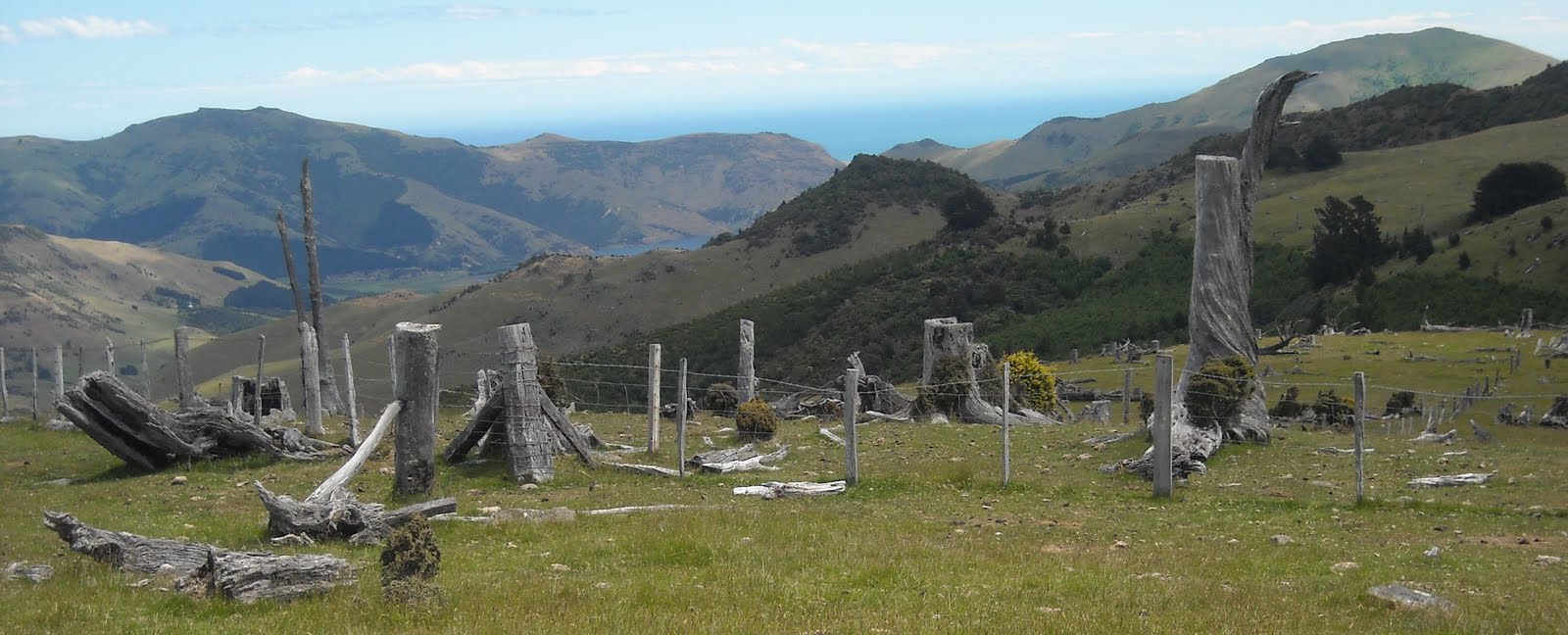
Following a fence and farm road, the track rose gently past grey weathered stumps and stunted bush: totaras, tree fuchsias, horopitos, matagouris. I saw Port Levy pine forests sloping down to Port Levy, and at Port Levy mouth I saw parallel oyster farm lines in the water, both sides of Port Levy mouth.

2010. Summit Walkway view of Little River

2010. Summit Walkway view of The Monument, Purau Saddle & Port Hills
Behind I had lovely views of Mt Bradley, Mt Herbert and Southern Alps beyond. Mt Herbert sloped down to The Monument and across Purau Saddle to Mt Evans. Across Canterbury Plains I saw Mt Thomas and Puketeraki Range. Pegasus Bay swept round to distant Alps and Kaikouras Ranges dropping to the Pacific. A glorious day for 100 km views & wandering with the gods.

2010. Summit Walkway view of Waipuna Saddle. Mt Sinclair left, Akaroa hills beyond

2010. Waipuna Saddle view of Mt Fitzgerald & Mt Sinclair
At the end of the bush pocket, I crossed a stile by a fence on a nameless hilltop (738m) above Waipuna Saddle, and saw that Summit Walkway followed fences which switchbacked up from Port Levy Saddle, down and up Waipuna Saddle, then veered down towards Port Levy and sidled up to Mt Fitzgerald summit.

2010. Waipuna Saddle view of Little River

2010. Totaras, Waipuna Saddle, Summit Walkway

2010. Waipuna Saddle farm gate & totaras. Mt Sinclair left

2010. Totaras, Waipuna Saddle. Mt Sinclair beyond

2010. Closeup totaras, Waipuna Saddle

2010. Waipuna Saddle sign, stile & totara grove
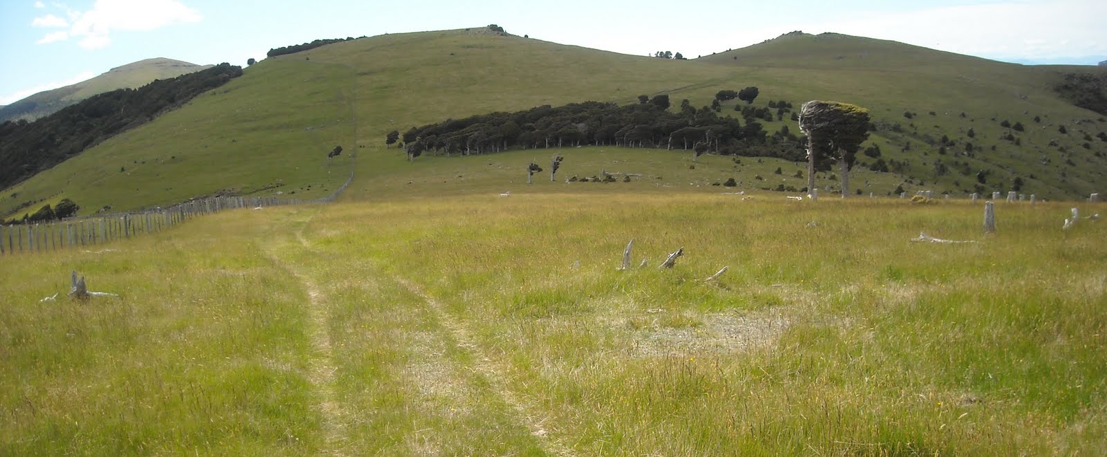
Following a fence down Waipuna Saddle, Summit Walkway went through exposed grassland with views down Little River valley to the Pacific on my right. On my left I passed a grove of windblown totaras (the trees mostly inverted L shaped by southerlies) pointing in the direction of Port Levy and Mt Fitzgerald.

2010. Waipuna Saddle view of Port Levy & Pegasus Bay
For most of Summit Walkway I passed thousands of grey-weathered, twisted, contorted totara stumps and trunks, scorched by old fires. Loggers had left a logging wasteland on the summit and down saddle slopes.
"Greedy bastards!" I thought, as only totara ghosts and grassland were left, with pockets of regenerating bush on slopes: scrubby totaras, horopitos, tree fuchsias, matagouris, bush lawyers, shield ferns...

2010. Totara ghosts, logging wasteland, Waipuna Saddle

2010. Summit Walkway, Waipuna Saddle
I crossed a stile which had WAIPUNA SADDLE sign on the fence, and followed a fence with old totara standards across grassy Waipuna Saddle, with views of Port Levy, Pegasus Bay and Kaikouras Ranges on my left.

2010. Waipuna Saddle gate & stile view of Mt Fitzgerald & Mt Sinclair

2010. Waipuna Saddle stile view of Hilltop & Akaroa hills
At the end of Waipuna Saddle I crossed another stile with views of Mt Fitzgerald (826m) and Mt Sinclair (841m). Southwards in the distance, I watched glinting cars trekking up Akaroa Rd from Little River to Hilltop, with a view to Akaroa hills and a glimpse of Akaroa Harbour.

2010. Summit Walkway totara ghosts view of Port Levy & Pegasus Bay

2010. Waipuna Saddle stile view of Mt Fitzgerald & Mt Sinclair
Summit Walkway veered left down a grassy slope and up a rocky path towards another nameless hill (717m) below Mt Fitzgerald, with views of Mt Evans and Port Levy left; Mt Fitzgerald and Mt Sinclair ahead; Akaroa hills right.

2010. Waipuna Saddle view of Akaroa Rd going up to Hilltop. Akaroa hills beyond

2010. Summit Walkway veering towards Mt Fitzgerald & Mt Sinclair
At midday I crossed another stile with Mt Fitzgerald and Mt Sinclair looming. Port Levy, Mt Evans and Pegasus Bay left. Mt Herbert, The Monument, Port Hills, Canterbury Plains behind.

2010. MTB, Summit Walkway, Mt Fitzgerald. View towards Little River hills & Pacific

2010. MTBs below Mt Fitzgerald, Summit Walkway

2010. MTBs lugging bikes, Summit Walkway, Mt Fitzgerald
On a rocky uphill section 9 MTBs passed either riding, pushing or carrying their bikes over steep, stony bits. The cyclists looked older than me. "Mad dogs and MTBs..." I thought, when the last grey faced bloke panted past.

2010. Tramper gear, totara ghosts & corral, Summit Walkway, Mt Fitzgerald

2010. Mt Fitzgerald stile & stumps view of Mt Herbert, The Monument, Port Hills, Alps
I caught up with the MTBs, while they lugged their bikes over another stile by twisted, weathered logs and a stock corral, by dead and half dead totaras with dry, grey branches screaming at the blue sky. My Christchurch Topo50 map showed a stock track going down Mt Fitzgerald slope to Richfield Rd and Port Levy.

2010. Summit Walkway, Mt Fitzgerald view of Lake Forsyth & Pacific
The MTBs left me behind when their cycling got easier on a farm road sidling up Mt Fitzgerald. A walking couple greeted me while passing on their way to Waipuna Saddle. Thereafter I had Summit Walkway and Mt Fitzgerald to myself.

2010. Summit Walkway, Mt Fitzgerald view of Mt Herbert

2010. Summit Walkway, Mt Fitzgerald view of Mt Herbert & The Monument

2010. Summit Walkway, Mt Fitzgerald view of Mt Evans & Pegasus Bay
While I sweated up the farm road on Mt Fitzgerald slope I had panoramic views:
- Lake Forsyth and Pacific.
- Waipuna Saddle.
- Port Levy Saddle, Mt Herbert, The Monument, Port Hills, Southern Alps.
- Port Levy, Mt Evans, Pegasus Bay, Southern Alps to Kaikouras Ranges.

2010. Summit Walkway, Mt Fitzgerald view of Mt Herbert, The Monument, Purau Saddle, Port Hills, Alps

2010. Summit Walkway, Mt Fitzgerald view of Mt Evans, Port Levy, Pegasus Bay
Sheep grazed steep roadside paddocks, and beside the farm track I saw scrubby kanukas, totaras, wind shaped matagouris and tiny subalpine celmisias with slender white petals and flies feeding on daisy discs. The higher I climbed Mt Fitzgerald the grander my views. I reached Mt Fitzgerald summit plateau 2.5 hours after leaving Port Levy Saddle.

2010. Celmisia alpine daisies, Mt Fitzgerald, Summit Walkway

2010. Matagouri, Mt Fitzgerald, Summit Walkway
I wandered Mt Fitzgerald summit over subalpine grasses, celmisias and some rocky patches, while scoffing late lunch: KBs steak and mushroom pie, muesli bar, CocaCola. I coolpixed 360 degree views of Southern Alps, Canterbury Plains, Pacific, Port Hills, Banks Peninsula:

2010. Mt Fitzgerald summit view of Mt Evans, Pegasus Bay, Lyttelton Harbour & Port Levy mouths

2010. Mt Fitzgerald summit Spaniards view of Pigeon Bay & Pacific

2010. Mt Fitzgerald summit view of Pigeon Bay & Pacific

2010. Mt Fitzgerald summit view of Mt Sinclair. Akaroa hills beyond

2010. Mt Fitzgerald summit view of Little River, Lake Forsyth, Pacific
- Pacific, Pigeon Bay hills and Pigeon Bay. It was 15 years since I last saw Pigeon Bay. Shortly after our arrival in NZ I drove to Pigeon Bay and vowed never again, as the Pigeon Bay - Port Levy dirt road was narrow, steep and dangerous.
- Mt Sinclair, distant Akaroa houses speckling Akaroa hills, Akaroa Harbour, Pacific.
- Little River valley, Lake Forsyth, Pacific.
- Mt Fitzgerald summit plateau with a bushy SE drop towards Mt Fitzgerald Reserve.
- Mt Herbert, Canterbury Plains, Southern Alps.
- Mt Herbert sloping down to The Monument, Port Hills, glimpse of Lyttelton Harbour, Canterbury Plains, Southern Alps.
- Mt Evans, Pegasus Bay, Canterbury Plains, Mt Thomas, Puketeraki Range.
- Port Levy mouth, Pegasus Bay, Pacific, Kaikouras Ranges.

2010. Mt Fitzgerald Reserve bush & Mt Fitzgerald summit

2010. Mt Fitzgerald summit view of Waipuna Saddle & Port Levy Saddle going up Mt Herbert

2010. Mt Fitzgerald summit view of Mt Herbert, The Monument, Port Hills, Alps
Standing at a NE point on Mt Fitzgerald summit, with a single sweep of my head I saw both sides of Banks Peninsula: Pigeon Bay and Pacific - Mt Sinclair - Little River, Lake Forsyth, Pacific.
At another summit point I saw Port Levy mouth left and Pigeon Bay right with hills sloping down to the Pacific in between. Besides grasses, celmisias, scrubby matagouris, totaras and kanukas, on north facing slopes golden Spaniards grew.

2010. Mt Fitzgerald Summit Walkway view of Mt Evans, Port Levy, Pegasus Bay

2010. Mt Fitzgerald Summit Walkway view of Port Levy & Pegasus Bay

2010. Mt Fitzgerald Summit Walkway view of The Monument, Purau Saddle, Mt Evans, Port Hills, Alps

2010. Mt Fitzgerald Summit Walkway view of The Monument, Purau Saddle & Port Hills

2010. Mt Fitzgerald Summit Walkway view of Mt Herbert & The Monument

2010. Mt Fitzgerald Summit Walkway view of Little River hills, Lake Forsyth & Pacific

2010. Celmisia alpine daisy, Mt Fitzgerald Summit Walkway

2010. Macrocarpa walking stick & matagouri, Mt Fitzgerald Summit Walkway

2010. Mt Fitzgerald Summit Walkway view of The Monument, Purau Saddle, Port Hills, Alps

2010. Mt Fitzgerald Summit Walkway view of Mt Herbert
I descended Mt Fitzgerald and returned to Port Levy Saddle the way I came in 2.5 hours. My return trek was cooler, but more humid, as a curved band of clouds covered my route. While I walked, more cloud bands formed over the Pacific, both sides of Banks Peninsula.
2010. Mt Fitzgerald Summit Walkway stumps & fence view of Lake Forsyth & Pacific

2010. Mt Fitzgerald Summit Walkway stumps & fence view of Mt Herbert, The Monument, Port Hills, Alps

2010. Dead & half dead totaras, Mt Fitzgerald Summit Walkway

2010. Totara ghosts, Mt Fitzgerald Summit Walkway

2010. Totara ghost, Mt Fitzgerald Summit Walkway

2010. Bushlawyer, Mt Fitzgerald Summit Walkway

2010. Totara ghosts by a knoll, Waipuna Saddle Summit Walkway
Westwards I had grand views again of Alps, Banks Peninsula hills, Port Hills, Pacific. As it was cooler I gave more attention to fantastic, weathered shapes of totara logs and stumps left decades before by messy, greedy loggers. Two Australasian harriers soared thermals above Mt Fitzgerald slopes.

2010. Waipuna Saddle Summit Walkway view of Mt Fitzgerald & Mt Sinclair

2010. Totara ghosts, Waipuna Saddle Summit Walkway

2010. Waipuna Saddle Summit Walkway view of Port Levy & Pegasus Bay
2010. Waipuna Saddle totara grove, Summit Walkway

2010. Waipuna Saddle totaras, Port Levy, Pegasus Bay

2010. Waipuna Saddle totaras & Mt Fitzgerald
On Waipuna Saddle again I wandered through the dark totara grove, which had little understorey - a few broadleafs, ferns, weeds, small tree nettles, unpalatable horopitos and cow pats, a glorified byre where farmers mucked up catchment with effluent.

2010. Totaras, Waipuna Saddle

2010. Broadleaf & totaras, Waipuna Saddle
Coda:
Fault focus. November 2010. Waipuna Saddle: When I climbed Banks Peninsula's Mt Fitzgerald I didn't know there was a gap between big quakes. We'd already endured the 4 September 2010, M7.1 Quake, caused by the Greendale Fault, but would still experience the 26 December 2010 Quake & 22 February 2011 Quake & 13 June 2011 Quake, the latter two quakes, M6.3s, causing Christchurch liquefaction-damages. The 23 December 2011 Quake swarm from Pegasus Bay would cause more liquefaction damage to eastern suburbs like Parklands.
The 26 December 2010 Quake would be caused by Christchurch Fault under Christchurch CBD. The 22 February 2011 Quake would be caused by Port Hills Fault, 185 deaths. The 13 June 2011 Quake would be caused by Banks Peninsula Fault, from Sumner to Pigeon Bay, close to Mt Fitzgerald & Mt Sinclair. The 23 December 2011 Quake swarm would be caused by the Pegasus Bay Fault.
Pegasus Bay Fault & Banks Peninsula Fault ran roughly north-south. The Greendale Fault & Christchurch Fault & Port Hills Fault ran roughly west-east.
My climbing Mt Sinclair was postponed, as hill-walking became too dangerous, due to rockfall hazard, landslide hazard & cliff-fall hazard.
Content & pics Copyright Mark JS Esslemont.
No comments:
Post a Comment