
22.08.11. Shag Rock POLLUTED WATER sign, Avon-Heathcote Estuary mouth, Main Rd / Marriner St, post June 13 quake. Rivers were sewage polluted by quake damaged sewer pipes

After dropping Luke off at Sullivan Ave polytech, I drove to Clifton for snaps. Main Rd: By Avon-Heathcote Estuary mouth, I stopped at quake-stunted Shag Rock below Clifton sea-cliff, snapping broken cliff-top houses & two layers of shipping-containers, protecting traffic from rockfall & housefall at the cliff-base from Shag Rock all along Marriner St to Gollan Point. Shag Rock had a POLLUTED WATER sign as Avon River & Heathcote River were open-sewers due to mangled sewage-pipes.

22.08.11. 2 layer, shipping container cordon protecting traffic from Clifton rock fall & house fall, Marriner St, post June 13 quake


I drove up steep, damaged Clifton Tce, stopping to snap a trashed retaining-wall: Roadside concrete-blocks covered in black-plastic on the roadside slope strengthened the steep roadside against slips. On the roadside opposite the retaining wall, a white / orange plastic-bollard-barricade went up the toad. Beachside of Clifton Tce, the footpath was slumped & cracked. A flattened-garage was below.

22.08.11. Quake collapsed garage, Clifton Tce, post June 13 quake

22.08.11. Retaining wall repair after quake damage, Clifton Tce, post June 13 quake

Further up Clifton Tce, corner house tiles were shaken off a roof, a retaining-wall was broken, there was more damage to roadside garages, all were steel-mesh-fence-cordoned.

22.08.11. Quake damaged house roof, Clifton Tce, post June 13 quake


22.08.11. Quake damaged house roof, Clifton Tce, post June 13 quake. Cave Rock & Scarborough beyond

22.08.11. Quake damaged garages, Clifton Tce, post June 13 quake


I drove along Kinsey Tce, on the edge of Clifton clifftop to the small carpark near the top of Mulgans Track. Houses built on the clifftop were quake & gravity destroyed. No liquefaction was seen, but Kinsey Tce had badly damaged road, footpaths & houses. A red turret was split in two on an old, wooden ruined-house.
Mulgans Track top, a skewed threat-sign:
DANGER
SLIP-ROCK FALL

22.08.11. Signs at Mulgans Track top, Kinsey Tce, post June 13 quake

22.08.11 Quake damaged housing, Kinsey Tce & views over Moncks Bay, Avon-Heathcote Estuary, Moncks Spur, Redcliffs, post June 13 quake


22.08.11. Kinsey Tce, quake damaged, house view of Southshore Spit, post June 13 quake
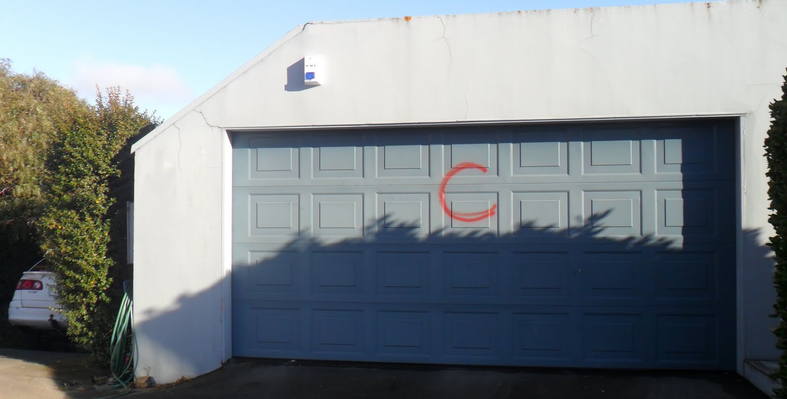
Kinsey Tce: Ruined-houses were collapsed, retaining-walls were collapsed, garages were crooked, house-walls were cracked, roof-tiles were loose. Several houses were red-stickered. Some houses were USAR / TF spray-painted. C marks on walls or garage-doors showed USAR / TF had checked the property was Clear of human bodies, alive or dead. Spray-painted NO GO threat-signs forbade people from their own properties.

22.08.11. Quake damaged Kinsey Tce view, Barnett Park, Mt Pleasant, post June 13 quake

22.08.11. Quake broken retaining wall, Kinsey Tce, post June 13 quake


22.08.11. Orange, plastic, road cone cordon. Orange, roadside pump & temp metal bridge, Kinsey Tce, post June 13 quake

22.08.11. Quake tilted garages, Kinsey Tce, post June 13 quake

22.08.11. Red stickered, quake broken house & roof, Kinsey Tce, post June 13 quake

A roadside-pump stood near Kinsey Tce end, a temporary steel-bridge covered a black-plastic-pipe across the road. Six months post 22 February 2011 Quake, Kinsey Tce still had portaloos as sewage-pipes were still stuffed.

22.08.11. Quake rubble, blue portaloo, Kinsey Tce, post June 13 quake

22.08.11. Red stickered, quake damaged house, Kinsey Tce, post June 13 quake
Kinsey Tce ruins had Council red-stickers:
DO NOT APPROACH OR ENTER THIS BUILDING
THIS BUILDING IS A DANGEROUS BUILDING UNDER SECTIONS 121 AND
124 OF THE BUILDING ACT 2004 (DUE TO RISK FROM ROCKFALL
AND / OR OTHER HAZARDS)
NO ENTRY IS PERMITTED
USING OR OCCUPYING THIS BUILDING IS AN OFFENCE PURSUANT TO
S 128 OF THE BUILDING ACT 2004...
Some Kinsey Tce buildings had Council green-stickers:
ATTENTION
POWER HAS BEEN REMOVED...
Those green-stickers weren't to be confused with Council green-stickers allowing access to buildings.
Since quakes, Council green-stickers & red-stickers were all over Christchurch.


22.08.11. Quake damaged garage, Kinsey Tce, post June 13 quake

22.08.11. Grey portaloo, Kinsey Tce, post June 13 quake
While I admired views over Moncks Bay, Avon-Heathcote Estuary, Redcliffs & beyond over smoggy Christchurch to snowy Alps, a M4.2 quake jolted, shaking overhead power-cables. Deja vu: I'd seen power-cables shake in another quake in Merivale. GeoNet reported the present quake: 8.38am, M4.2, 10km depth, 10km SE of Lyttelton.
An old lady drove out of her quaked-driveway, smiling, waving, no worries. After that aftershock, I trekked very carefully along deserted Kinsey Tce: road cracks, ruined-houses, retaining-wall damages, lateral-spreading, showed that cliff-top housing could tumble towards the Pacific.

22.08.11. Quake cracked pavement & driveway, Kinsey Tce, post June 13 quake


22.08.11. Steel mesh fence cordon. Quake damaged house, Kinsey Tce, post June 13 quake


22.08.11. Quake damaged housing, quake tilted power poles. Kinsey Tce, post June 13 quake. Scarborough backdrop


22.08.11. Orange, plastic, road cone cordon. Quake damaged Kinsey Tce & Clifton Tce view, Sumner & Scarborough, post June 13 quake
Last Saturday 20.08.11, 7.31pm: M4.0 quake, depth 10km, within 5km of Christchurch (GeoNet). Quakes were still going strong nearly a year post 4 September 2010 Quake!
Wed 10.10.12. Quakes would be going strong more than a year later: 11.51am, M4.2 quake, 11km depth, 15km E of Christchurch (GeoNet). Christchurch then was the most active crustal-quake-zone on earth.

22.08.11. USAR / TF NO GO sign on garage doors, Clifton Tce, Post June 13 quake
Clifton Tce: USAR / TF had spray-painted NO GO NO GO on two garage-doors. Would that graffiti reduce future salvage-value? That wilful damage by USAR / TF teams could be seen all over Christchurch.
Building material demolished from ruined-housing & ruined commercial-buildings was trucked to Burwood Dump. From 2014, the salvage-contractor Luke would work for saved as much wood as possible: kauri, mahogany, totara, rimu, matai... They would then resell the wood on Trade Me, or recycle it as furniture.

22.08.11. Quake damaged Clifton Tce, post June 13 quake


Tuawera Tce: Similar damages as Kinsey Tce: destroyed Clifton houses, spectacular sea-views.
USAR / TF graffiti continued: NO GO on garage-doors, C on ruined house-walls & ruined garage-doors. Front-doors had Council red-stickers & electricity-switched-off green-stickers. I read the graffito carefully to see which USAR / TF team checked a house, as RT identified a Response Team & TF identified a Task Force, USAR team. Both TF & RT were trained in search & rescue.

22.08.11. Tuawera Tce / Clifton Tce view, Scarborough, post June 13 quake

22.08.11. Rock fall, red portaloo, Tuawera Tce, post June 13 quake

22.08.11. Quake damaged house, Tuawera Tce, post June 13 quake

22.08.11. C marked garage door, USAR / TF Clear mark, showing nobody home, Tuawera Tce, post June 13 quake

22.08.11. Quake mud slip below garage, Tuawera Tce, post June 13 quake

22.08.11. Quake damaged house, Tuawera Tce, post June 13 quake

22.08.11. Rubbish bins, blue portaloo, Tuawera Tce, post June 13 quake

22.08.11. NO GO, Response Team, pavement graffiti, Tuawera Tce, post Feb 22 quake

22.08.11. Quake damaged house, Tuawera Tce, post June 13 quake


22.08.11. Quake damaged housing, Tuawera Tce, post June 13 quake


22.08.11. Quake damaged retaining wall, Tuawera Tce, post June 13 quake

22.08.11. Orange, plastic, road cone cordon. Blue portaloo, USAR / TF C marked garage door, showing Clear, nobody home, Tuawera Tce, post June 13 quake

22.08.11. Tuawera Tce view, Avon-Heathcote Estuary, post June 13 quake

22.08.11. Tuawera Tce view, Moncks Bay, Moncks Spur, Balmoral Hill, post June 13 quake

22.08.11. Tuawera Tce view, Moncks Bay, Redcliffs, post June 13 quake

22.08.11. Quake damaged retaining wall, Tuawera Tce, post June 13 quake


22.08.11. Orange, plastic, road cone cordon. Tuawera Tce, blue portaloo, temp metal bridge, post June 13 quake

22.08.11. USAR / TF C marked garage door, Clear meant no bodies, Tuawera Tce, post June 13 quake

Near the end of Tuawera Tce, I trekked up steps between houses to two concrete water-reservoirs. A lady jogger passed. I continued upwards to Panorama Rd by Brownlee Reserve.

22.08.11. Steps above Tuawera Tce view, Southshore Spit, post June 13 quake

22.08.11. Clifton reservoir, above Tuawera Tce view, Southshore Spit, post June 13 quake


22.08.11. Brownlee Reserve, Panorama Rd, post June 13 quake
Panorama Rd: Three chatty ladies passed while I admired city, estuary, Pacific & Alpine views by a quake-stalled housing- development. I snapped more damaged houses on my trek up Panorama Rd.

22.08.11. Panorama Rd view, Avon-Heathcote Estuary, Redcliffs, Christchurch, Southern Alps, post June 13 quake

22.08.11. Panorama Rd view, Balmoral Hill above Redcliffs, Christchurch red zoned CBD, snowy Southern Alps, post June 13 quake

22.08.11. Panorama Rd view, Redcliffs rock falls, Avon-Heathcote Estuary, post June 13 quake


22.08.11. Green portaloo, walkers, quake damaged housing, Panorama Rd, post June 13 quake

22.08.11. Quake damaged house, Panorama Rd, post June 13 quake


22.08.11. Pavement, quake hole by letterboxes, Panorama Rd, post June 13 quake

22.08.11. Quake damaged house, Panorama Rd, post June 13 quake


22.08.11. Rubbish bins, blue portaloo, Panorama Rd, post June 13 quake. Richmond Hill beyond trees
Panorama Rd / Clifton Tce: I turned right along Revelation Rd, snapping more ruined-houses. A postman walked past, smiling, lugging two postbags. Clifton roads were too steep for his postie-bike.

22.08.11. Quake damaged housing, Panorama Rd / Clifton Tce, post June 13 quake


22.08.11. Panorama Rd / Clifton Tce view, Richmond Hill, Scarborough & Pacific, post June 13 quake


22.08.11. Quake damaged house, Revelation Rd, post June 13 quake


Revelation Dr: High on the Port Hills, beyond Gethsemane Gdns I trekked down Galilee Ln to the end, past more ruined-houses. A broken-concrete, road-retaining-wall was above another stalled housing-development, viewing Christchurch & beyond.

22.08.11. Quake damaged house by Gethsemane Gdns, Revelation Rd, post June 13 quake


22.08.11. Revelation Rd view, Avon-Heathcote Estuary, Southshore Spit, Pegasus Bay, post June 13 quake. All that water caused massive liquefaction during quakes

22.08.11. Quake damaged / repaired Revelation Rd / Galilee Ln, post June 13 quake

22.08.11. Postman, blue portaloo, Galilee Ln, post June 13 quake

22.08.11. White / orange, plastic bollard cordon. Quake broken, retaining wall, Galilee Ln, post June 13 quake


22.08.11. Galilee Ln view, Moncks Spur, Redcliffs, Balmoral Hill, Avon-Heathcote Estuary, post June 13 quake

22.08.11. Galilee Ln view, Moncks Bay, Redcliffs, Avon-Heathcote Estuary, Southshore Spit, post June 13 quake

22.08.11. Galilee Ln, blue portaloo view, Christchurch, snowy Southern Alps, post June 13 quake
From Clifton, I saw panoramic Christchurch, Alpine views & watery vistas: snowy Southern Alps, Port Hills, CBD, Sumner, Scarborough, Redcliffs, Southshore Spit, Avon-Heathcote Estuary, Pacific. Added to fault-fractures, all that water caused massive liquefaction during quakes. All Clifton roads I trekked had roadside portaloos. Cliftonians were still in shit six months post 22 February 2011 Quake!

22.08.11. Clifton Tce view, Richmond Hill, Scarborough, post June 13 quake

22.08.11. Orange, plastic, road cone cordon. Quake damaged, Clifton Tce, post June 13 quake. Richmond Hill left

22.08.11. Quake damaged house, Clifton Tce, post June 13 quake


Clifton Tce: I returned down to my car, pastoral views on my right across Richmond Hill, snow still speckling Port Hills, broken Sumner below: Sumner Beach, Cave Rock, Scarborough, Pacific views.

22.08.11. Quake damaged, retaining wall, quake tilted, power pole, Clifton Tce, post June 13 quake


22.08.11. Clifton Tce view, Sumner, Scarborough, quake damaged housing, post June 13 quake


22.08.11. Quake damaged house, Clifton Tce, post June 13 quake


The postman passed again, fittest man in Christchurch. My down-trek: more broken-road, broken-footpaths, roadside-portaloos, ruined-houses: chimneys gone, fallen roof-tiles, broken boarded-windows, broken boarded-walls, broken retaining-walls.

22.08.11. Garage door, USAR / TF C showed Clear no bodies, Clifton Tce / Tuawera Tce, post June 13 quake


22.08.11. Clifton Tce view, quake split house, Kinsey Tce, post June 13 quake


22.08.11. Quake broken, retaining wall, Clifton Tce, post June 13 quake
When I checked CERA's Landcheck website, all Clifton roads I trekked were white-zoned, "mapping still underway." Home-owners were still in limbo about their land & homes, six months post 22 February 2011 Quake.
*Trekked Main Rd, Marriner St, Clifton Tce, Kinsey Tce, Tuawera Tce, Panorama Rd, Revelation Dr, Galilee Ln. 148 snaps.
Coda:
Sun 14.02.16. Valentines Day, M5.7 quake. Rockfalls at Godley Head, Sumner's Richmond Hill, Peacocks Gallop below Clifton.
Content & pics Copyright Mark JS Esslemont.
Hi there
ReplyDeleteI just flicked through most of your images today - 8 April '13. Will go back an have another look later. I live on Tuawera Tce.
Re the 'C's that were on garage and house doors - they were put there one week after the Feb 22 2011 quake, when we were evacuated off the hill, due to someone thinking the cliffs were going to collapse. 'C' did indeed stand for Clear. They made sure everyone knew about the emergency and were going to get off the hill. Not everybody did. The chap that came to my door was in a panic, huge black irises in his eyes, screaming at me, standing about 3 feet away from me. There was no way he was going to let me go and turn off my generator - I just walked past him and did it anyway.