Parklands East focus. The Press 24.12.11, PM John Key generalised while on Hawaii holiday: "What we can conclude is that the most significant damage from the earthquakes is really the psychological damage and the impact on the confidence of the people of Christchurch." Key couldn't possibly know my mind, nor Leah's mind, nor Jake's & Luke's minds & what caused our behaviour & impacted our confidence. Key couldn't possibly know the minds of other quake-survivors. The 1 000s of quakes we'd endured over the last 15 months were not psychological. The joltings, shakings, rumblings, liquefactions & damages were real. As real as wind-blown liquefaction grit in my hair & beard & the dirt on my bare feet after I trekked ruined quakeland
Key should wander Parklands & smell shit in quakemired streets! Smell roses in shitty streets too! Key should see citizens once more digging mud away from homes & tell them that's psychological!
Post 13 June 2011 Quake, when I'd trekked Parklands a bit, it was obvious many houses were built on beach sand, unlike Christchurch CBD's grey liquefaction-silt. Again, I wanted to see what had happened to Parklands, but soon post 23 December 2011, Xmas Quake Swarm, before liquefaction-damages were sanitized by CERA.
Boxing Day, 26.12.11: Early morning, I drove east along
Queen Elizabeth 11 Dr. Further on, 10km from my Burnside home, along
Travis Dr by
Travis Wetland, I descended into swampland, liquefaction-land to the coast. Orange-plastic-road-cone-cordons abounded.
Parklands was close to the coast. I drove along once more liquefactioned
Bower Ave past weedy EQC porta-cabin offices at
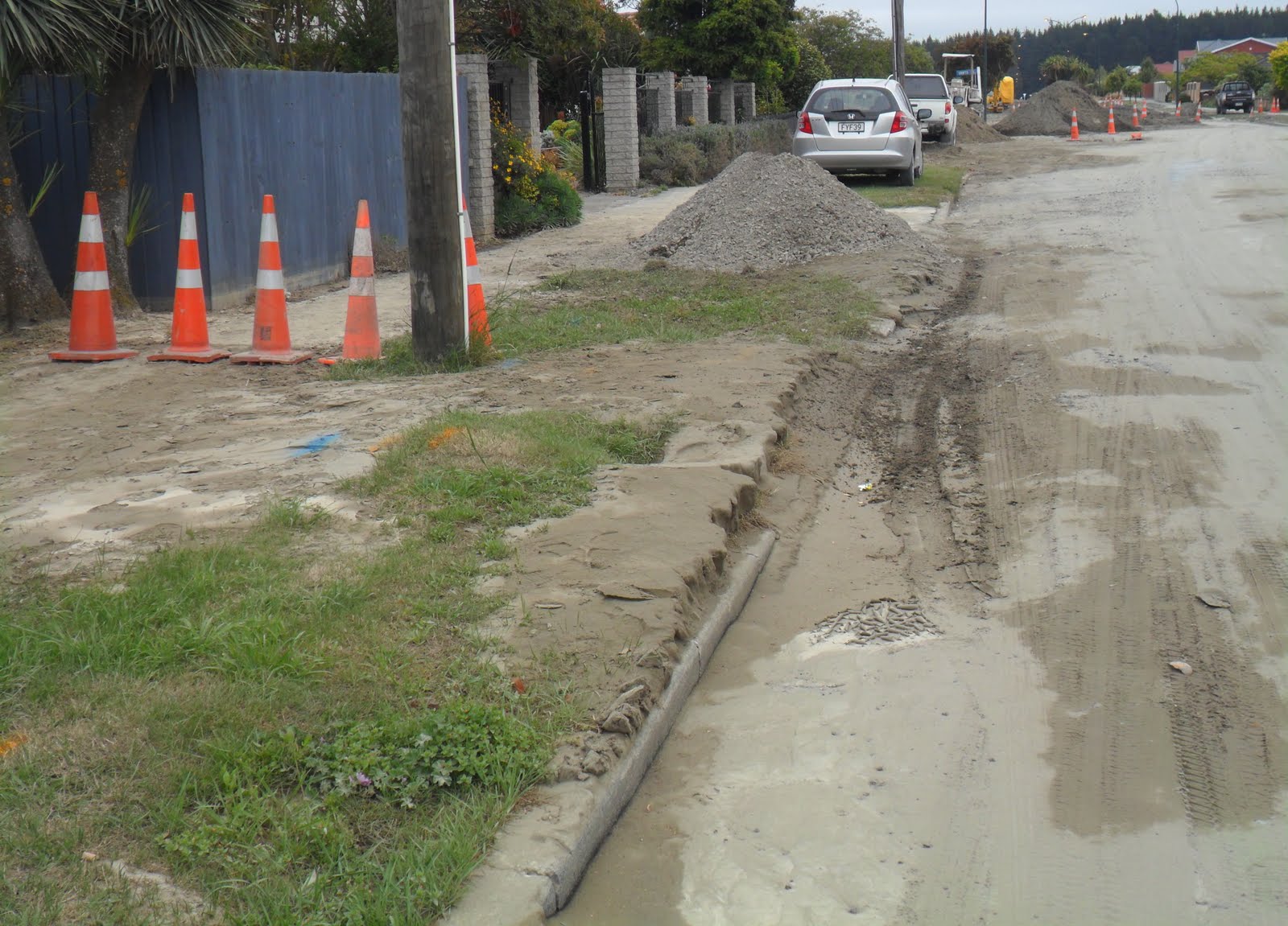
QE11 Park entrance. I snapped sinkholes & roadside liquefaction-flooding & quakemire heaps & cracked-mud on footpaths.
Post 13 June 2011 Quake, when I'd seen QE11 Park, the park & surrounding roads were a mass of sinkholes & quakemire.
Bower Ave / Flemington Ave: I snapped 23 December 2011, Xmas Quake Swarm's liquefaction-damage & quakemire heaped on roadsides, orange-plastic-road-cone-cordoned.

26.12.11. Orange, plastic, road cone cordon. Bower Ave liquefaction damage, 23.12.11 quake swarm, nr Flemington Ave cnr

26.12.11. Flemington Ave liquefaction damage, 23.12.11 quake swarm
Bower Ave: Due to 23 December 2011 Xmas Quake's liquefaction-damage, traffic was detoured via
Pinewood Ave &
Beach Rd back to Bower Ave.

26.12.11. Orange, plastic, road cone cordon. Bower Ave detour by Pinewood Ave, due to 23.12.11 quake swarm, liquefaction damage

26.12.11. Orange, plastic, road cone cordon. Bower Ave liquefaction damage, sinkhole nr Beach Rd, 23.12.11 quake swarm


 Bower Ave:
 Many quake-cracks & sinkholes I saw in Parklands that morning were 1-2m deep, or deeper. Many liquefaction-heaps were higher than cars.

26.12.11. Bower Ave flooding, liquefaction damage, 23.12.11 quake swarm

26.12.11. Orange, plastic, road cone cordon. Bower Ave sinkhole, liquefaction damage, 23.12.11 quake swarm


Xmas Quake liquefaction looked as bad as 13 June 2011 Quake liquefaction I'd seen. I parked on
Bower Ave / Queenspark Dr, by Waimari Beach Golf Club's liquefactioned-gate & muddy golf course. Leah's relatives who lived on
Queenspark Dr told us the Xmas Quake Swarm shook their house throwning items around. (2020. With his girlfriend, Jake would move to an apartment at Cottonwood St off Queenspark Dr, with a Parklands Reserve view, a more stable abode than where he'd lived in a quake-damaged garage & damaged apartments & damaged houses).

26.12.11. Liquefactioned carpark entrance, Waimairi Beach Golf Club, Bower Ave, 23.12.11 quake swarm

26.12.11. Orange, plastic, road cone cordon. Bower Ave liquefaction damage, nr Queenspark Dr cnr, 23.12.11 quake swarm

I figure-eight trekked liquefactioned Parklands roads:
Bower Ave towards
Bottle Lake Forest Park. I snapped mud-heaps, sinkholes, cracked-roads & cracked-footpaths, orange-plastic-road-cone-cordoned. Uncleared quakemire was knee-high in places.
Farm Ln: Muddy.
Rue De La Mare: Muddy.

26.12.11. Orange, plastic, road cone cordon. Liquefaction damage, Bower Ave / Farm Ln, 23.12.11 quake swarm


26.12.11. Orange, plastic, road cone cordon. Liquefaction damage, Bower Ave / Rue De La Mare, 23.12.11 quake swarm

26.12.11. Liquefaction damage, Bower Ave, nr Rue De La Mare, 23.12.11 quake swarm
 Bower Ave:
 I snapped early morning joggers & walkers & some early mud-shovellers & & others barrowing mud. There was no sign of vaunted Student Volunteer Army diggers, nor Farmy Army volunteer diggers, as in other quakes. Two sucker-trucks rumbled by slurping shekels. Again! A water-tanker drove past laying liquefaction-dust.
Crofts Ln: Brown mud.

26.12.11. Liquefaction damage, Bower Ave / Crofts Ln, 23.12.11 quake swarm


26.12.11. Liquefaction damage, Forest Park Estate, Bower Ave, 23.12.11 quake swarm


 Bower Ave:
 Forest Park Estate housing was deeply liquefactioned. One section, only half the road was mud-cleared, the other side was still lumpy & quakemired. Footpaths were covered in drying mud, driveways were muddy, some were cleared, some were still being cleared. Roads off Bower Ave were deeply liquefactioned.

26.12.11. Liquefaction damage, Forest Park Estate, Bower Ave, 23.12.11 quake swarm


End of Bower Ave, I chatted to a tall, grizzled man, who'd dug mud away from his garden, driveway & verge on Xmas Day. His garden was immaculate. Quakemire was all around, knee-high mud on the road. He inquired where I lived & why I was snapping pics?
I said, "My wife's Scottish cousin in Nairn told us there was no UK news about our Xmas Quake Swarm. No deaths, no international news! I'm snapping blog pics to show her what's happening. Despite mud, local gardens are beautiful, filled with flowers."
He pointed to his neighbour's rose garden. Nearby, in the road was a muddy sinkhole, water-filled, scummy. "Good luck to you," I said, trekking on.

26.12.11. Liquefaction damage, Forest Park Estate, nr Broadhaven Reserve & Bottle Lake Forest Park, Bower Ave, 23.12.11 quake swarm

 Broadhaven Ave
, near
Broadhaven Reserve: Quakemire was partly cleared. Sinkholes. Mud-diggers. Roads off Broadhaven Ave were deeply liquefactioned. Quakemire lessened the further I trekked west from the coast.

26.12.11. Liquefaction damage, Bower Ave / Broadhaven Ave, nr Broadhaven Reserve, 23.12.11 quake swarm


26.12.11. Liquefaction damage, Broadhaven Ave, seen from Bower Ave junction, 23.12.11 quake swarm

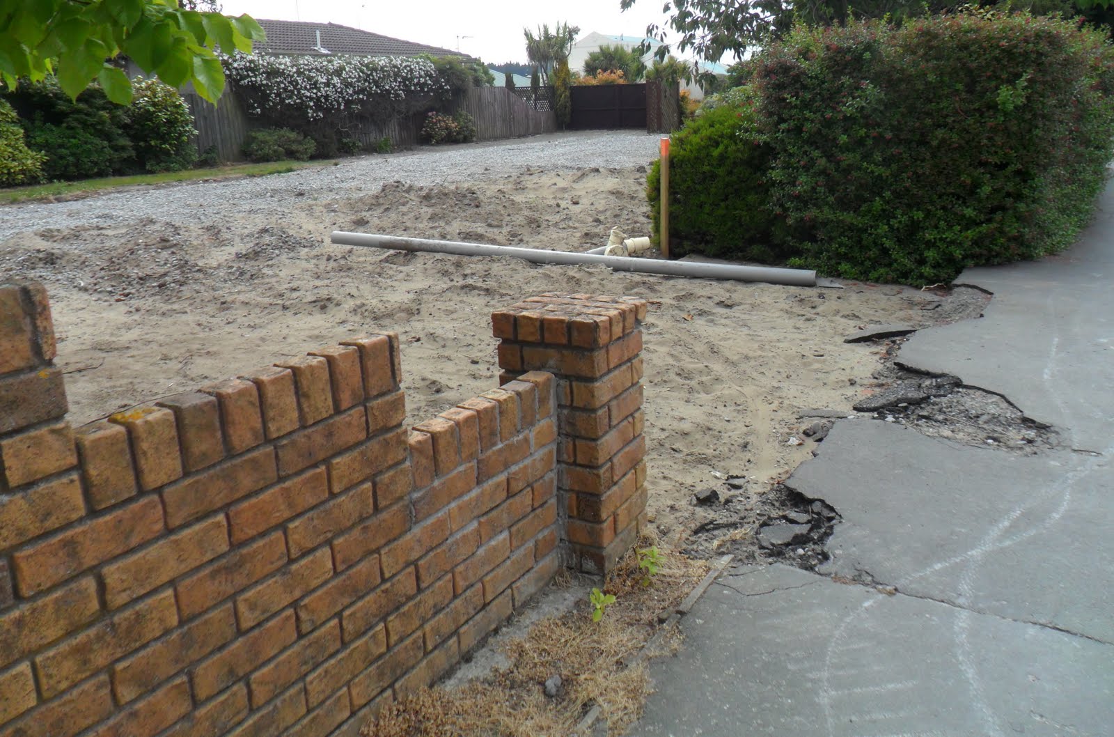
26.12.11. Liquefaction damage, black, plastic, sewage tank, Broadhaven Ave, 23.12.11 quake swarm

26.12.11. Sinkhole, liquefaction damage, Broadhaven Ave, looking towards Bower Ave, 23.12.11 quake swarm

26.12.11. Liquefaction damage, Broadhaven Ave by Broadhaven Reserve, 23.12.11 quake swarm


A lost contractor driving a SUV asked for directions to
QE11 Park. I hopped into his SUV & directed him at liquefactioned
Broadhaven Ave / Inwoods Rd.

26.12.11. 30 km/h speed limit. Liquefaction damage, Broadhaven Ave, nr Inwoods Rd junction, 23.12.11 quake swarm

 Inwoods Rd:
 Roughly parallel to Bower Ave, many liquefactioned roads in between. Not so muddy, like
Arosa Pl &
Bottle Lake Dr, which I'd muddily trudged post 13 June 2011 Quake.

26.12.11. Liquefaction damage, Broadhaven Ave / Inwoods Rd, 23.12.11 quake swarm


26.12.11. Orange, plastic, road cone cordon. Liquefaction damage, Inwoods Rd, 23.12.11 quake swarm


26.12.11. Liquefaction damage, Inwoods Rd / Arosa Pl, 23.12.11 quake swarm


26.12.11. Green, plastic, sewage tank, Inwoods Rd / Queenspark Dr, 23.12.11 quake swarm

26.12.11. Serial quake shaken, but not liquefactioned, Queenspark Dr housing, 23.12.11 quake swarm
Queenspark Dr to
Bower Ave again: Little quakemire up to the shopping centre. Before the shopping centre, in
Parklands Reserve carpark, a leaky water-tanker was parked, with a pipe for six taps. A sign:
WATER MUST BE
BOILED BEFORE
USE


26.12.11. Post quake water tanker, Parklands Reserve, Queenspark Dr, 23.12.11 quake swarm


26.12.11. Supermarket. Liquefaction damage, Queenspark Dr, 23.12.11 quake swarm

26.12.11. Library. Liquefaction damage, Queenspark Dr, 23.12.11 quake swarm

26.12.11. Liquefaction damage, Queenspark Dr, nr shops, 23.12.11 quake swarm


The shopping centre & Council library was liquefactioned. Closer to Bower Ave again there was massive liquefaction. Mud everywhere!
Lamorna Rd: Muddy.
Hurst Pl:: A huge quakemire pile. Near
Bower Ave a Land Rover parked in roadside mud.

26.12.11. Liquefaction damage, Lamorna Rd / Queenspark Dr, 23.12.11 quake swarm

26.12.11. Liquefaction damage, Queenspark Dr, between Lamorna Rd & Hurst Pl, 23.12.11 quake swarm


26.12.11. Orange, plastic, road cone cordon. Liquefaction damage, Queenspark Dr / Hurst Pl, 23.12.11 quake swarm


26.12.11. Liquefaction damage, Queenspark Dr, between Hurst Pl & Bower Ave, 23.12.11 quake swarm


I drove up liquefactioned
Bower Ave & along liquefactioned
Broadhaven Ave where I'd just trekked & parked by
Forest Dr. I wanted to see more Parklands damage and complete a smaller circuit of my figure-eight trek.

26.12.11. Liquefaction damage, Queenspark Dr / Bower Ave, 23.12.11 quake swarm

26.12.11. Liquefaction damage, Bower Ave / Broadhaven Ave, 23.12.11 quake swarm

26.12.11. Quake crack, liquefaction damage, Bower Ave, nr Boadhaven Ave cnr, 23.12.11 quake swarm

26.12.11. Liquefaction damage, Bower Ave / Broadhaven Ave, 23.12.11 quake swarm

26.12.11. Orange, plastic, road cone cordon. Liquefaction, sinkhole damage, Broadhaven Ave / Bottle Lake Dr, 23.12.11 quake swarm
Forest Dr: As liquefactioned as Bower Ave: Quakemired-sinkholes, quakemired-roadsides, quakemired-footpaths. Part-cleared road & part-cleared driveways. Liquefaction was bad at
Courtfield Cl junction & down Courtfield Cl. Some men wore gloves while digging. A Park Estate catastrophe!
Floral-decorations: Parklands citizens decorated orange-plastic-road-cones two months before it would become fashionable to decorate orange- plastic-road-cones with flowers honouring 185 quake dead during the 22 February 2011 Quake. I snapped Xmas tinsel & floral-decorations on several orange-plastic-road-cones, which brightened the grey quakemire.

26.12.11. Liquefaction damage, Broadhaven Ave / Forest Dr, 23.12.11 quake swarm

26.12.11. Liquefaction damage, Forest Dr, 23.12.11 quake swarm


26.12.11. Liquefactioned Broadhaven Reserve, seen from Forest Dr / Courtfield Cl, 23.12.11 quake swarm. Bottle Lake Forest Park beyond

26.12.11. Liquefaction damage, Forest Dr / Courtfield Cl, 23.12.11 quake swarm


26.12.11. Liquefaction damage, Forest Dr, between Courtfield Cl & Monterey Pl, 23.12.11 quake swarm


I trekked quakemire past
Broadhaven Park, past muddy, sinkholed
Monterey Pl, to
Anglesea Ave & back, past
Inwoods Rd, Inwoods Cl & a repeat bit of muddy
Broadhaven Ave, past a house demolition-site back to my muddy car.

26.12.11. Liquefaction damage, Forest Dr / Monterey Pl, 23.12.11 quake swarm


26.12.11. Liquefaction damage, Forest Dr, between Monterey Pl & Anglesea Ave, 23.12.11 quake swarm

26.12.11. Green, plastic, sewage tank, Broadhaven Ave, nr Inwoods Cl, 23.12.11 quake swarm

26.12.11. Liquefaction damage, Inwoods Cl / Broadhaven Ave, 23.12.11 quake swarm


26.12.11. House demolition site, Broadhaven Ave, nr Inwoods Cl, 23.12.11 quake swarm
I drove home via muddy
Bower Ave again, past a parked fire-engine & firemen calming a woman who was distressed about a water-filled sinkhole outside her quakemired-home.

26.12.11. Fire engine. Liquefaction damage, Bower Ave, nr Broadhaven Ave cnr, 23.12.11 quake swarm


26.12.11. Liquefaction damage, Bower Ave / Broadhaven Ave, 23.12.11 quake swarm. Broadhaven Reserve & Bottle Lake Forest Park beyond
In October before the 23 December 2011 Xmas Quake Swarm, CERA designated Parklands roads I trekked to be green-zone: Repaired housing would need TC3 foundations, meaning damaged land was liquefaction-prone requiring stronger foundations. And continued rates for Council!
Why was Parklands' sandy swampland developed? University & polytech studies & Council consents were behind quake-reality! But developers & Council profited.
On CERA's Landcheck website, I looked up Parklands roads:
Forest Dr, Courtfield Cl, Monterey Pl, Bower Ave, Broadhaven Ave. Despite the massive liquefaction, they were all green-zoned by geotech engineers Tonkin & Taylor!
Back to Burnside, I drove along
Frosts Rd by
Travis Wetland, past another
QE11 Park gate, flooded since the 22 February 2011 Quake. Travis Wetland claimed its own across Frosts Rd & into trashed QE11 Park. (2022: That quake-sunk area beside Frosts Rd would still flood after heavy rains.)
Official responses to 23 December 2011 Xmas Quake destruction: CERA boss Sutton flew in a helicopter over the disaster area & said it was bad. Other officials holiday-bullshitted, like Key's "psychological damage." 24.12.11. The Press headline: "New quakes vindicate land decisions Brownlee." That was misinformation as Parklands was green-zoned by CERA & dug itself out of quakemire after three quakes! Did that vindicate NZ National governments' land decisions? Brownlee was on holiday & returned to Christchurch soon post-quake. Mayor Parker returned from his holiday in Taupo mouthing inanities on 23.12.11 TV, as facile as deputy mayor Button had done on TV. Council CEO Marryatt on holiday in Queensland didn't bother to return, despite public fury at his recently announced salary increase. Marryatt's Council minions did some silt-digging, piling silt on roadsides on 24.12.11 the day after the Xmas Quake Swarm began. Xmas Day & Boxing Day there no mud-digging by authorities!
Xmas afternoon, after dropping off Luke & his girlfriend at New Brighton, Leah & I did a Parklands drive. I drove some of the roads I would trek the next day on Boxing Day. We saw no Council workers & no CERA contractors in Hi-Vis vests digging mud on Xmas Day.
Boxing day, when I trekked for about three hours, 8-11am, all I saw was one water-tanker spraying water on
Bower Ave by Forest Park Estate. Two diggers were parked on mud there. There were no Council workers, nor CERA contractors in Hi-Vis vests removing silt wherever I walked on Boxing day morning. Just local residents mud-digging.
Over the last 15 months, quakes moved from west to east from Canterbury Plains across Christchurch & Port Hills & were presently active in Pegasus Bay.
*Trekked Bower Ave, Broadhaven Ave, Inwoods Rd, Queenspark Dr, Forest Dr. 152 snaps.
Coda:
Sunday 14.02.16. Valentines Day, M5.7 quake. Deja Vu. Liquefaction-damage again, sinkholes & sewage-leaks at
Bower Ave, Broadhaven Ave, Hurst Pl, Courtfield Cl &
Linkwater Way.
Content & pics Copyright Mark JS Esslemont.
See Flooded Christchurch area can't be fixed - expert (The Press / Stuff Co).
See Parklands zoning right, engineer says - Tonkin & Taylor engineer (The Press / Stuff Co).