May 2010. George Goussard Dispatch: "Things are really not looking good. Most government services have 'gone the way of all flesh'. (My apologies to heroes in government service who are still trying to make it work).
Our borders are open to the north, and the poor, hopeful and criminals of Africa are daily streaming across our borders. Stolen cars go the other way, stocking the streets of Maputo, Gaberone, Lusaka and Harare. The chance of police solving any crime reported locally is dim.
...'s purse was stolen some time ago. The criminal was caught red-handed but according to the detective there was 'no case.' The good news is that the detective has been fired for stealing police property. Control of borders is to be given to the army, as police were unable to handle the situation. The army says they do not have the manpower.
The biggest coal-fired power station is being constructed in the Transvaal. Three sites have been identified where 3 nuclear power stations will be built in the next 10 years.
Municipalities in probably half of SA are seriously malfunctioning, sewage works not functioning properly, water not purified properly. A list of municipalities in the newspaper rated for water purification this week, and Koffiefontein rates as 0%, electrical infrastructure not being maintained.
Roads on the platteland are also not being maintained properly anymore. The whole of NW province (Mafeking, Klerksdorp) has been taken / was going to be taken over? by the central government, because of the state of chaos reigning there. The N1 (Cape Town to Johannesburg) is perfect, as is the N2 (Cape Town to Durban). The speed limit is 120 on most platteland roads, but to do more than 60-80 is extremely dangerous (potholes).
Theft has become a way of life with the example largely set by politicians / government officials. Estimated that 35% of all electricity generated is stolen (translate: the rest of us pay). Virtually every semi-state is bankrupt / financially struggling: Escom, SABC, Land Bank, SA Airways, Road Accident Fund - third party insurance.
The education system is floundering and the head of the SA Communist Party is now minister for tertiary education. Afrikaans universities are being forced to educate in English.
The government now wants to pass a law exempting all households earning less than R80 000 per annum from property tax (translate: the rest of us must make up the shortfall). Remember we now have 12 million (out of 48 million) receiving a monthly government grant / salary. The intention is to push this up to 18 million (translate: we must cough up more tax).
The old dream of Mandela of a non racial society has gone by the wayside. More and more politicians and others (Black Managers Forum) are shouting for race to be brought back (basically to strip wealth from the 'haves'). Julius Malema is the worst example of this. He panders to the worst in people, and can only hold up false hope to millions who have been unable to strip the wealth of SA, and promise them their day will come, if they only vote for him. The next general election is in 2012.
Politicians and their families (Zuma's wives and children serve on DOZENS of boards of directors of companies) are stripping SA of its wealth and calling it 'doing business.' Levels of corruption in all levels of government is just unbelievable. What SA needs is a 'Strong Man' to bring sanity to the chaos, but I do not foresee such a development. A culture of self enrichment and greed is being firmly established in SA, led by ANC politicians at all levels. Mines have largely been sold out to empowerment companies (translate: families of politicians). This week Aurora Company (Mandela's grandson and Zuma's nephew) owning a lot of Anglo mines went bankrupt. They are now looking to Communist Chinese for capital to start up the mines again.
The free press is under attack, as they are unsympathetic to corrupt politicians. Courts are now also under fire, because government has lost a lot of court cases where they ignored the constitution. ('Unfair' they cry). Judges must now be transformed (translate: no white males) to ensure government friendly verdicts. In today's paper they are calling for a change in the constitution to transfer farm land more easily into black hands. The fact (they themselves admit) that 80% of farm land transferred into black ownership does not produce anything anymore is conveniently ignored.
I can go on like this forever, but let me say a few positive things. The further south you live the better things work. Johannesburg is a hubbub of activity and development. Private medical services are excellent and many people still fly in from the rest of the world to have ops done (big business). On the surface things look 'normal.'
Business is still good in SA. Lots of rich Europeans retiring to Cape Town and environs. Richer parts of Cape Town, Clifton, Camps Bay, etc, have been bought by very rich, corrupt politicians from Africa. Unbelievable number of Nigerians in SA, and the vast majority seem to be busy with illegal activities, especially drugs and prostitution. So too lots of Chinese coming in (perlemoen and rhino horn). Cape Town developing into a nice modern city comparing with the rest of the world. Our airports have all been rebuilt and are impressive.
Afrikaans music / art / drama are blossoming as never before. The first 3D SA movie 'Jock of the Bushveld' to be released soon worldwide. Huge film studios being constructed near us. Survey results released last week showing that there is a significant move (I presume especially amongst young people) of a common SA identity and an acceptance of other races. That said, we are getting a huge xenophobia problem in SA. The ordinary black person has an intense hatred of black people from Africa (especially Zimbabwians, Nigerians, Somalis - every area now has a Somali shop). With 25% unemployment rate they cannot be expected to welcome these people.
Damn! Going negative again.
I should finish with this thought: The world is becoming smaller and smaller, and as time goes on the ability / power of governments / crackpots will become less and less to cause chaos. So time is against chaos developing in SA, and hopefully in time some law and order will be established and modern values and norms can establish properly. In the meantime there is little I can do, but do my best every day to make the world around me a more pleasant and civilized place."
See "We've lost our pride - Tutu" (News24). State of SA
See "20 Miners Executed" (Sowetan)
Monday, May 3, 2010
Saturday, May 1, 2010
Mt Herbert Summit via Port Levy Saddle

2010. Little River Road Signs to Akaroa & Christchurch

2010. Little River Road Signs to Western Valley & Port Levy
As I wanted to climb Mt Herbert (919 m) via Port Levy Saddle (estimated distance 10 kms return), I drove 55 kms along Akaroa Road from Christchurch to Little River, where I turned left along Western Valley Road, a metalled road going over Port Levy Saddle to Port Levy (17 kms).
Caution: Port Levy Saddle and Mt Herbert summit - exposed to the elements. Hill walking fitness, food, water, weatherproof gear needed.

2010. Port Levy Saddle view of Western Valley

2010. Port Levy Saddle view of Port Levy

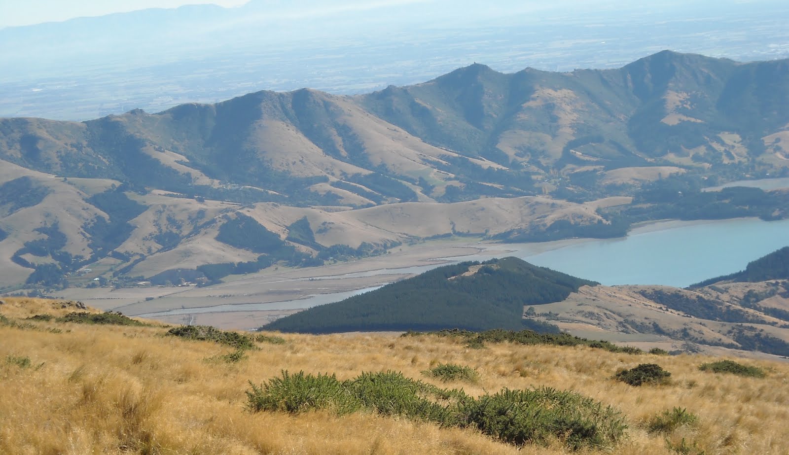
2010. Port Levy Saddle view of Western Valley Road to Port Levy. The Monument (711 m) & Mt Evans (703 m) backdrop
For about 9 kms Western Valley Road wound steeply over corrugations up to Little River / Port Levy Saddle Carpark (660 m). By the carpark, I had down valley views to Little River. Port Levy side, I saw The Monument, Canterbury Plains, Southern Alps to Kaikouras Ranges, and a pine forest going down to Port Levy.
Two dead possums hung on a fence by my car. Southern side of the road amongst rocks and weathered tree stumps a DOC sign stated:
PORT LEVY SADDLE
SUMMIT WALKWAY
MONTGOMERY PARK AND SUMMIT ROAD -> 3 hrs 30 min

2010. DOC Port Levy Saddle Sign, Port Levy Saddle
I walked westwards in the opposite direction towards Kaituna Spur, where another DOC sign stated:
PORT LEVY SADDLE
SUMMIT WALKWAY
MT HERBERT SHELTER -> 2 hrs 30 min
I disagreed with that time, as it would take me 2 1/2 hours to summit Mt Herbert, with Mt Herbert Shelter another 1/2 hour walk down Mt Herbert / Mt Bradley Saddle.

2010. DOC Port Levy Saddle Sign, Kaituna Spur Carpark
I walked the grassy track on Port Levy Saddle through an avenue of weathered fence posts towards Kaituna Spur. I passed old logging mess: weathered stumps and grey logs sticking out of brown grass.
I passed prickly shield ferns, horopitos, scrubby tree fuchsias and small totaras, the track winding steeply between Kaituna Spur (807 m) and a smaller hill (763 m).

2010. Port Levy Saddle view of Western Valley & Hills above Little River. Pacific backdrop

2010. Port Levy Saddle view of Banks Peninsula Hills

2010. Port Levy Saddle view of Western Valley & Hills above Little River

2010. Port Levy Saddle view of Mt Bradley (855 m) & Mt Herbert (919 m)
Along the way, I watched a shepherd driving his maroon ute, while his five sheepdogs herded sheep from Kaituna Spur down to the track. I greeted the shepherd in passing, and from a high point below Kaituna Spur, with views of Port levy, I watched the shepherd leaving his ute, and controlling his dogs and sheep by whistling to his dogs.

2010. Port Levy Saddle view of Sheep Flock on Kaituna Spur

2010. Port Levy Saddle view off Sheep on Kaituna Spur above Port Levy
I sidled past Kaituna Spur on my left with western views of Canterbury Plains, Southern Alps, Mt Bradley (855 m) and Mt Herbert (919 m). On my right I saw the pine forest and Western Valley Road descending to Port Levy, with views of The Monument (711 m) and Mt Evans (703 m).

2010. Port Levy Saddle view of The Monument (711 m), Mt Evans (703 m) & Port Levy

2010. Port Levy Saddle view of My Bradley (855 m)

2010. Bush Pocket, Port Levy Saddle
After crossing a stile on Kaituna Spur slope, I passed a pocket of totaras overlooking old logging-ravaged Kaituna Valley, with bare valley slopes going up Mt Bradley, and slopes going up to podocarp forest in Mt Herbert Reserve. I would pass five bush pockets on Port Levy Saddle, interspersed with grassland.
Through another bush pocket I passed regenerating vegetation: matagouri, dominant totaras, ferns, horopitos, tree fuchsias, bush lawyers, muehlenbeckias, coprosmas, lichens on mossy rocks, grasses, wooly mulleins, clematis creepers...

2010. Bush Pocket & Dead Totaras, Port Levy Saddle
On my right, views of Port Levy. On my left, Port Levy Saddle grassy slopes, old logging slopes with views down Kaituna Valley to Lake Ellesmere, Kaitorete Spit and Canterbury Bight, vanishing in Pacific and Alpine haze. Westwards - Canterbury Plains, while closer Mt Bradley and Mt Herbert loomed large.

2010. Bush Pockets, Port Levy Saddle above Kaituna Valley. Mt Herbert, Mt Bradley backdrop

2010. Bush Pockets, Port Levy Saddle above Kaitina Valley. Mt Herbert backdrop
In a third bush pocket on Port Levy Saddle, I passed tall totaras, broadleafs and scrubby kanukas. In a fourth pocket of regenerating bush, several southerly wind-sculptured totaras marched up Port Levy Saddle. On top I passed weathered stumps and dead totara trunks against blue sky.
The track descended Kaituna Valley a bit, where I passed unmarked Monument Track turnoff descending logged wasteland into Kaituna Valley, which I'd wandered before. Far below, piebald horses grazed amongst wind-blasted stumps.

2010. Totara Ghosts, Port Levy Saddle below Mt Herbert (919 m)

2010. Totara Ghost, Port Levy Saddle overlooking Kaituna Valley, Lake Ellesmere, Kaitorete Spit, Pacific

2010. Totara Ghosts, Port Levy Saddle overlooking Kaituna Valley, Lake Ellesmere, Kaitorete Spit, Pacific

2010. Totara Ghosts, Port Levy Saddle, overlooking Port Levy Pine Forest

2010. Totara Ghosts, Port Levy Saddle overlooking Kaituna Valley, Lake Ellesmere, Pacific
The fifth pocket of scrubby bush descending Kaituna Valley would need hundreds of conservation years to become podocarp forest again.
I zigzagged up to Port Levy Saddle crest again, where 1 1/2 hours after leaving Kaituna Spur Carpark I found a track junction with two signs: One stated PORT LEVY SADDLE by a post with a rusty shovel and a sledge-hammer attached. Another sign directed trampers along MONUMENT TRACK to The Monument and Mt Evans.

2010. Port Levy Saddle Sign, Port Levy Saddle
Midday, Port Levy Saddle crest: I stopped for cool breezes, coolpixing and lunch - CocaCola, Pams steak pie, muesli bar.

2010. Monument Track, Port Levy Saddle

2010. Mt Herbert view of Monument Track & Port Levy
Continuing up Port Levy Saddle, I climbed the steep, pole-marked track through windy grassland for the next half hour to Mt Herbert summit ridge. On my way up, I crossed a stile and had grand views of Kaituna Valley, Lake Ellesmere and Pacific.
Sidling right hand paths, I saw Port Levy, Pigeon Bay hills, Okains Bay hills, The Monument, Mt Evans, Port Hills, Pegasus Bay, Canterbury Plains and Southern Alps to Kaikouras Ranges. Looking back, I saw hilltops over Kaituna Valley, Little River and Akaroa.

2010. Mt Herbert view of Port Levy Saddle

2010. Mt Herbert view of Kaituna Valley

2010. Mt Herbert view of Kaituna Spur & Banks Peninsula Hills

2010. Mt Herbert view of Banks Peninsula Hills beyond Port Levy Saddle

2010. Mt Herbert view of Hills above Port Levy & Pigeon Bay

2010. Mt Herbert view of Mt Evans (703 m) & Pegasus Bay
On top of Mt Herbert mini-summit (913 m), at the broken mast I stopped to coolpix spectacular views. By the broken mast a shipping container, in camouflage colours, had several small aerials on top.

2010. Mt Herbert view of The Monument (711 m), Mt Evans (703 m), Port Levy, Pacific

2010. Mt Herbert Summit view of Lyttelton Harbour, Port Hills, Canterbury Plains, Southern Alps

2010. Mt Herbert Summit view of Lyttelton Harbour, Port Hills, Canterbury Plains, Pegasus Bay

2010. Mt Herbert Summit view of Mt Evans (703 m) Lyttelton Harbour, Port Hills, Pegasus Bay

2010. Mt Herbert Summit view of Mt Evans, Purau, Lyttelton Harbour, Port Hills, Canterbury Plains, Pegasus Bay

2010. Mt Herbert Summit Ridge. Lyttelton Harbour, Port Hills, Southern Alps backdrop

2010. Mt Herbert Summit view of Kaituna Valley, Lake Ellesmere, Kaitorete Spit, Pacific
For the next half hour, I dodged cowpats in tussockland along Mt Herbert summit ridge, while admiring views:
Lake Ellesmere, Pacific, Canterbury Plains.
Mt Bradley, Mt Herbert summit ridge, Canterbury Plains.
The Monument, Mt Evans, Purau, Diamond Harbour, Lyttelton Harbour, Port Hills, Pegasus Bay, Canterbury Plains, Southern Alps. While I walked a helicopter circled Mt Bradley and Mt Herbert summits, twice.

2010. DOC Sign, Mt Herbert Summit 919 m & Cows

2010. DOC Sign, Mt Herbert Summit 919 m & Banks Peninsula Hills
By rocks near Mt Herbert Summit, 20 grey codgers, including 2 women, replete with day packs and walking sticks, passed me on their way to The Monument. At Mt Herbert Summit trig beacon and masts (919 m) a herd of black cattle sheltered, chewing cud and staring at me.
I watched two Australasian harriers soaring thermals above Mt Herbert Summit. Two codgers lay on brown grass, boots off, admiring western views down Mt Herbert dipslope: Lyttelton Harbour, Port Hills, Canterbury Plains, Southern Alps. I coolpixed 360 degree summit views.

2010. Mt Herbert Summit view of Kaituna Valley & Pacific

2010. Mt Herbert Summit Masts & Cows

2010. Mt Herbert Summit Cow view of Mt Bradley (855 m), Lake Ellesmere, Canterbury Plains, Southern Alps

2010. Mt Herbert Summit Cow view of Mt Bradley, Port Hills, Canterbury Plains, Southern Alps
2010. Mt Herbert Summit view of Head of The Bay, Port Hills, Canterbury Plains, Southern Alps

2010. Mt Herbert Summit view of Charteris Bay, Head of the Bay, Governors Bay, Port Hills, Canterbury Plains, Southern Alps

2010. Mt Herbert Summit view of Quail Island, Lyttelton Harbour, Port Hills, Canterbury Plains, Southern Alps

2010. Mt Herbert Summit view of Diplsope, Lyttelton Harbour, Port Hills, Canterbury Plains, Pegasus Bay, Southern Alps

2010. Mt Herbert Summit view of Lyttelton Harbour, Mt Cavendish, Mt Pleasant, Port Hills, Canterbury Plains, Pegasus Bay

2010. Mt Herbert Summit view of Purau, Lyttelton Harbour, Port Hills, Pegasus Bay

2010. Mt Herbert Summit view of Mt Evans (703 m), Purau, Lyttelton Harbour, Port Hills, Pegaus Bay

2010. Mt Herbert Summit view of Monument Track, The Monument (711 m), Port Levy, Pacific
With afternoon sun on my back, I returned from Mt Herbert Summit, down Port Levy Saddle back to my car in 2 hours 10 minutes.

2010. Mt Herbert Summit view of The Monument (711 m), Port Levy, Pacific

2010. Mt Herbert Summit view of Purau, Lyttelton Harbour, Port Hills, Canterbury Plains, Pegasus Bay

2010. Mt Herbert Mini Summit (913 m) view of Mt Herbert Summit (919 m)

2010. Mt Herbert Mini Summit (913 m) view of Mt Bradley (855 m) & Lake Ellesmere

2010. Mt Herbert Summit view of Banks Peninsula Hills

2010. Mt Herbert Summit view of Port Levy Saddle

2010. Port Levy Saddle Sign: Monument Track Purau Saddle. Port Levy backdrop

2010. Port Levy Saddle Sign, Port Levy Saddle

2010. Totara Ghost, Port Levy Saddle

2010. Port Levy Saddle, Totara Ghost & Port Levy

2010. Port Levy Saddle Bush Pocket, Upper Kaituna Valley

2010. Port Levy Saddle, Wind Blown Totaras, Upper Kaituna Valley. Lake Ellesmere & Pacific backdrop

2010. Port Levy Saddle, Old Podocarp Logging. Kaituna Valley & Lake Ellesmere backdrop

2010. Port Levy Saddle, Regenerating Bush, Upper Kaituna Valley

2010. Summit Walkway view of Port Levy Saddle & Mt Herbert Summit

2010. Summit Walkway View of Port Levy Saddle Pine Forest, The Monument (711 m) & Mt Evans (703 m)

2010. Summit Walkway view of Port Levy Pine Forestry & Port Levy

2010. Summit Walkway view of Mt Herbert Summit (919 m)

2010. Summit Walkway view of Western Valley going down to Little River, Banks Peninsula

2010. Port Levy Saddle view of Western Valley Road & Banks Peninsula Hills

2010. Dead Possums, Port Levy Saddle Carpark. The Monument (711 m) & Mt Evans (703 m) backdrop
From Port Levy Saddle Carpark, I drove along Western Valley Road down the side of Port Levy Saddle, through pine forest to Port Levy. I looked at Port Levy School and St Pauls Anglican Church, both small wooden buildings.
On Purau Port Levy Road, by Purau Saddle I coolpixed Mt Herbert eastern summit ridge I'd just climbed.
I drove back to Christchurch via Purau, Diamond Harbour, Governors Bay and Dyers Pass over Port Hills.

2010. Port Levy School

2010. Road Signs, Port Levy

2010. Purau Saddle view of The Monument (711 m) & Mt Herbert (919 m)
Content & pics Copyright Mark JS Esslemont.
Subscribe to:
Comments (Atom)