Monday, August 29, 2011

CERA Regime. Christchurch, CBD Red Zone, Hi-Vis Vest Fools

Western red zone CBD focus. Sat 28.08.11. Over 6 months post Feb 22 Killer Quake & nearly a year post Sept 4 Darfield Quake, CBD occupier CERA relaxed its grip & opened a little western niche of Christchurch CBD red zone to the public, trumpeted by the media. The niche was from Oxford Tce & eastwards along little bits of Lichfield St & Tuam St to the steel mesh fence cordon near Colombo St.


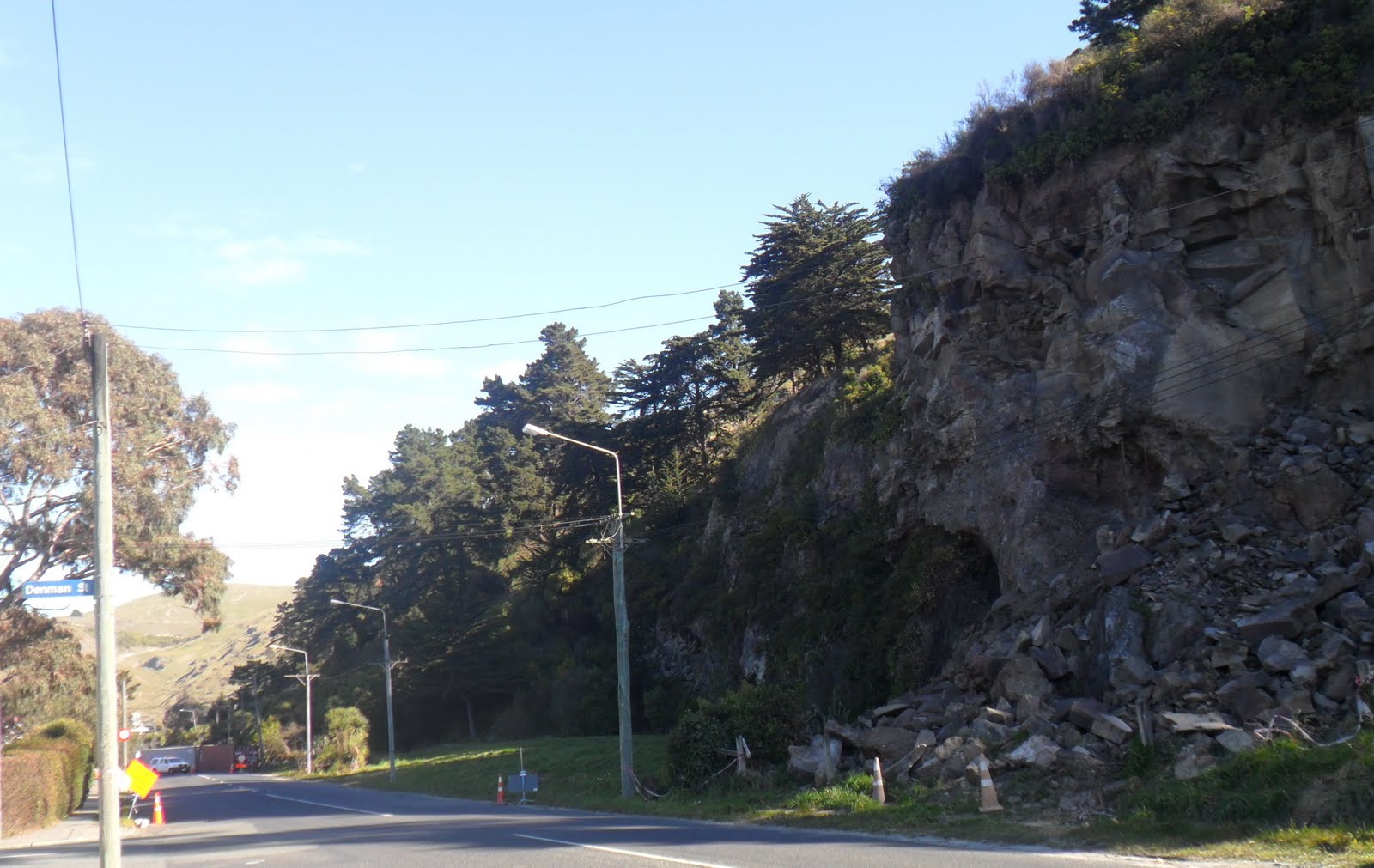
30.08.11. Quake cracked pavement by sewage polluted Avon River, Oxford Tce, post June 13 quake


30.08.11. Quake damaged, steel mesh fence cordoned, medical bldg, Oxford Tce, post June 13 quake. The bldg would be demolished

Over the past months, post Feb 22 Killer Qake, other red zone, CBD niches had slowly opened too. But public were still banned red zone access, public safety & guarding property excuses, guarded by cops & NZDF soldiers at variable cordon checkpoints, although the National State of Emergency was long gone.


30.08.11. Steel mesh fence cordon. Orange digger, quake demolition site, Oxford Tce, post June 13 quake

CERA guarded the red zone CBD & opened it little by little, after demolitions. It didn't need much brain nor time to demolish quake broken bldgs. Why did it take so long for CERA demolishers to open the CBD red zone niche between Lichfield St & Tuam St?


30.08.11. Quake damaged pavement by sewage polluted Avon River, Oxford Tce, post June 13 quake


30.08.11. Oxford Tce view, Cambridge Tce, quake damaged bldg, post June 13 quake

Tue 30.08.11. I parked my car near Christchurch Hospital & trekked to the western red zone niche, snapping quakescapes along sewage polluted Avon River, Oxford Tce.

Lichfield St:Empty Red zone, silent, USAR / TF graffitied ghosts, steel mesh fences & shipping container cordons. Steel mesh fence cordon sign:

NO THROUGH
     TRAFFIC
   PROPERTY
      ACCESS
        ONLY

Beyond a parking garage, behind Lichfield St steel mesh fence cordon, an orange digger demolished a bldg in clouds of dust. I tied my scarf round my mouth & nose, fearing asbestos pollution.


30.08.11. Orange, plastic, road cones, steel mesh fence cordon. Recently opened CBD red zone niche, Lichfield St, post June 13 quake


30.08.11. Quake damaged, steel mesh fence cordoned, USAR / TF graffitied bldg, red zone, Lichfield St, post June 13 quake

Between Lichfield St & Tuam St, behind a steel mesh fence cordon, 2 more orange diggers were parked on empty demolition sites. Post quakes, about half of Christchurch CBD bldgs would be demolished.


30.08.11. Steel mesh fence cordon. Orange digger demolition of quake trashed bldg, Lichfield St red zone, post June 13 quake


At the side of Lichfield St St steel mesh fence cordon, I trekked through a fence opening into a carpark by recently reopened business bldgs. I snapped more pics of the demolition & empty demolition sites between Lichfield St & Tuam St to Colombo St. I didn't know then that the area would become the temporary bus exchange, then Hoyts EntX, and the new Bus Interchange would be built across Colombo St.


30.08.11. Lichfield St view, quake damaged high rises: Hotel Grand Chancellor left, Westpac middle, Holiday Inn right, red zone, Christchurch CBD, post June 13 quake. The 3 high rises would be demolished
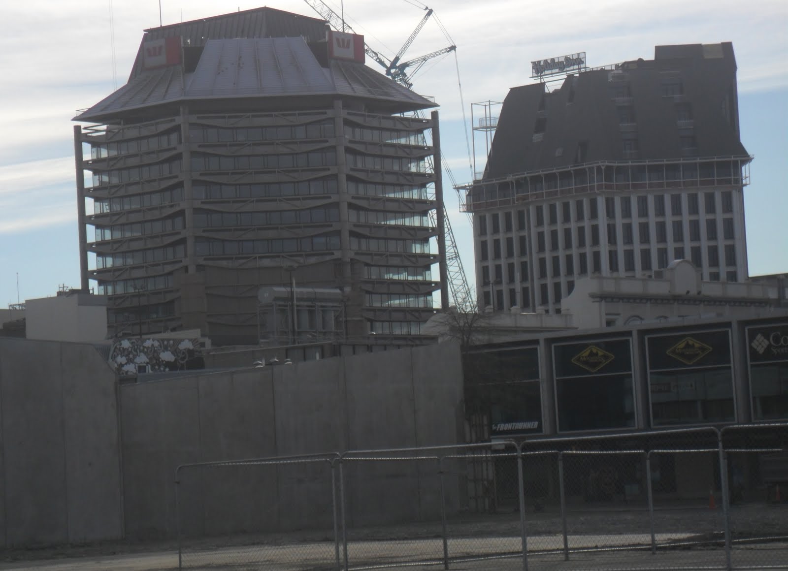

Backdrop multi-storey ghosts: Hotel Grand Chancellor; Westpac; Holiday Inn (all would be demolished). Colombo St ghost shops. Multi-storey, old Council ghost, Tuam St, would be demolished for the new Bus Interchange.


30.08.11. Post quake demolition sites, west side Colombo St, post June 13 quake. Backdrop: east side, old Colombo St shops & old Council bldg. Shops & Council bldg would be demolished for the new Bus Interchange

Demolishers had sanitized quake destruction, leaving Colombo St a clean movie set: Colombo St east side, ghosts awaited demolition. Men in hard hats & orange, Hi-Vis vests wandered empty demolition sites behind the steel mesh fence cordon: staring at ruins; taking snaps; nattering in groups; hanging around in a crane box; wandering a deserted parking garage, 4th floor; an orange digger demolishing in clouds of dust. I counted 2 orange diggers, 2 orange cranes & 1 white crane behind a steel mesh fence cordon. Only 1 orange digger was doing any work, a waste of time & money.


30.08.11. Steel mesh fence cordon. Orange digger, post quake demolition of quake trashed bldg, Lichfield St red zone, post June 13 quake


30.08.11. Two orange diggers, 2 orange cranes, 1 white crane, post quake demolition sites & quake damaged parking garage, Lichfield St red zone, post June 13 quake


30.08.11. Post quake demolition sites & Colombo St east side, quake damaged bldgs, post June 13 quake. Old Council bldg backdrop. East side shops & Council bldg would be demolished for the new Bus Interchange


While I snapped by a steel mesh fence cordon, a chinless, buck-toothed lady in orange, Hi-Vis vest, sans hard hat & wearing joggers, pointed at my jandals & twice barked, "This is not a public area!"

"You're talking nonsense!" I said. "Where's your hard hat & hard cap boots?" She shut up & left. Why Hi-Vis vest Fools wanted to boss public around post quakes was beyond me?


30.08.11. Business carpark view, post quake demolition sites & Colombo St east side bldgs awaiting demolition, post June 13 quake. Backdrop: Quake damaged Holiday Inn left & old Council bldg right. Both bldgs would be demolished


Her steel mesh fence cordoned carpark was behind empty demolition sites (soon to be the new, temp Bus Exchange) & other steel mesh fence cordons closer to Colombo St. Both ends of her steel mesh fence cordoned patch were open, with no official, access restriction notices from Lichfield St side, nor Tuam St side. Her carpark had a couple of skips filled with quake rubbish. Cardboard boxes & blue pallets were strewn by the steel mesh fence cordon.


30.08.11. Tuam St view, post quake demolition sites (soon to be the new, temp Bus Exchange) & parking garage. Central Police bldg behind left would be imploded 31.05.15. New Council bldg behind


30.08.11. Steel mesh fence cordon. Quake survivor, Council bldg, would become Tuam Library in 2012
 
I trekked closer to Tuam St steel mesh fence cordon, snapping quake damages & silent, orange, Hi-Vis vested men behind the cordon fence. A person was killed in the Feb 22 Killer Quake, Tuam St / Colombo St.

Southwards down Colombo St, 15 people were killed by the Feb 22 Killer Quake, old bldg bricks falling on 7 killed pedestrians & 8 people killed in the Sumner 702 (updated number 3) red bus.

I still got angry, questioning why those lethal old, brick bldgs weren't condemned & demolished post Sept 4 Darfield Quake? Dithering authorities, hounded by Heritage hailers, had more than enough time to demolish unreinforced, old, brick bldgs, as aftershock warnings had continued between Sept 4 Darfield Quake & Feb 22 Killer Quake.

Lichfield St - Tuam St: Bldgs in the red zone niche still had USAR / TF graffiti on ghost shop windows & doors. Behind the steel mesh fence cordon, a bldg's first floor, red cnr was nylon strapped against aftershocks.


30.08.11. Nylon strapped, quake damaged bldg, Tuam St red zone, post June 13 quake


30.08.11. ROAD CLOSED. Tuam St, steel mesh fence cordoned, red zone, post June 13 quake. Old Council bldg left would be demolished for the new Bus Interchange


30.08.11. Tuam St / Colombo St, post June 13 quake: 8 people were killed in the Sumner 702 (updated number 3) red bus, masonry falling from old, unreinforced bldgs nr Mollett St junction


30.08.11. Tuam St / Colombo St, post June 13 quake. The orange, Hi-Vis vested man faced where someone was killed in the Feb 22 quake. Old Council bldg, Tuam St beyond would be demolished for the new Bus Interchange


30.08.11. Tuam St, steel mesh fence cordon view, quake damaged, CBD, red zone bldgs, Colombo St & beyond, post June 13 quake


30.08.11. Steel mesh fence cordon. Former CBD red zone, Tuam St business, post June 13 quake. Cordon closed for 6 months post Feb 22 quake


Tuam St: I snapped more ghost shops, USAR / TF graffitied: Mastertrade Plumbing, Drake Leisure Co Ltd, S.I. McHarg Print Finishers... Through Lighthouse shop windows, I snapped broken lamps & chandeliers, 6 months post Feb 22 Killer Quake. USAR / TF graffiti marked C - Clear no bodies.


30.08.11. Quake damaged, Lighthouse shop, Tuam St, closed for 6 months post Feb 22 quake, in CBD, steel mesh fence cordoned, red zone


I returned to my car, past an orange digger loaded on a truck, ready for another demolition. I passed Antigua Boat Shed, by sewage polluted Avon River, then passed quake damaged, Christchurch Hospital.

How long would CERA take to open more CBD niches in the red zone? How many more Hi-Vis vested Fools would order public around? National govt declared States of Emergencies had enabled cops, soldiers & Hi-Vis vested Fools to order citizens around, causing an "us & them" ethos.

Mar 2013. More than 2 years post 22.02.11 Killer Quake, Christchurch CBD would still be red zoned, CERA occupied / NZDF cordoned, citizens banned. When I'd lived in apartheid SA, cops, soldiers & NO GO fenced areas symbolized SA's fascist state. Post quake Christchurch too was symbolized by cops, NZDF soldiers, Hi-Vis vested Fools, NO GO fenced areas & fascist CERA.


30.08.11. Green portaloo, Tuam St / Durham St Sth, former red zone, post June 13 quake


30.08.11. Orange digger on truck, ready for another post quake demolition, Tuam St, post June 13 quake

*Trekked Oxford Tce, Lichfield St, Tuam St. 49 snaps.

Wed 31.08.11. Aftershocks while I worked on blog pics:

1.15pm, M4.00, depth 5km, within 5km of Lyttelton.

1.30pm, M4.7, depth 11km, 20km SW of Christchurch. Jolted & rumbled our house while I uploaded pics.

2.26pm, M3.4, depth 12km, 20km SW of Christchurch. (GeoNet).

31.08.11. Christchurch Mail: "As of yesterday, we have had a staggering 2 684 aftershocks of magnitude 3.0 or higher batter our region."

Regarding insurance: "The Earthquake Commission (EQC) has received more than 388 000 claims for the Canterbury earthquakes, since September last year...

The Canterbury and Christchurch earthquakes are likely to rank globally as the fourth most costly for insurers since 1970 - after Northbridge, California, in 1994, the [M]9.0 earthquake and tsunami disaster in Japan in March this year, and Kobe, Japan in 1995."

Coda:

Fri 02.09.11. 3.29am, M4.9, depth 6km, 10km E of Lyttelton. (GeoNet).

Sat 03.09.11. Weekend Press. EQC's incompetence since the 04.09.10 Darfield Quake a year before:

"STATS...

All events include aftershocks.

No of claims 383 501
Open 324 336
Closed 59 165
Total paid to date $1 321 980 700"

After 1 year, EQC's successfully closed payouts, just 15%. NZ National govt said EQC's liability to quakes had increased by $4 billion to about $7 billion.

Sun 04.09.11. Sunny spring afternoon. Anniversary of the 04.09.10 Darfield Quake. City circuit drive, CBD & eastern suburbs:

Rolleston Ave: CBD sanitized zone. Busy scene, citizens & tourists viewed outside photo-poster exhibition, on the pavement by Christ's College & Canterbury Museum. Drawing people back into the CBD. Citizens & tourists strolled Worcester Blvd past Arts Centre ghost.

Hereford St / Cambridge Tce: CBD sanitized zone, by old, brick Library Chambers ghost, steel mesh fence cordoned, awaiting demolition.

Cambridge Tce: CBD sanitized zone. Citizens, tourists, rubberneckers viewed red zone, ghost CBD, across sewage polluted Avon River: cordoned ghost restaurants, ghost high rises, ghost streets. Lively Bridge of Remembrance, steel mesh fence cordoned across middle, pulsed with rubberneckers & cameras. Cordoned Cashel Mall  ghost, demolition sites.

New normal, post quake scene: South Library, Colombo St. Citizens enjoyed coffee, reading books, magazines, newspapers, selecting books & DVDs. Citizens watched plasma screen TV & worked on computers. South Library was more crowded due to Central Library closure & closures of many other Council libraries.

Later on, South Library, south wall would be steel braced, staying open for the public. Pre quakes, it was built too close to Heathcote River & would need post quake strengthening.

New normal, E suburbs: I drove past Bromley sewage ponds / sewage works, undergoing post quake repairs.

Estuary Rd, South New Brighton: Many orange, plastic, road cones, due to pipe excavations in road. (Cut to night view of New Brighton Pier, purple lit along pier length. Bar boozers at seaside bars. Bowhill Rd... Bower Ave... New Brighton Rd... still potholed & bumpy.)

Breezes Rd & Wainoni Rd: Quake scabby roads, due to post quake, patch repairs. Quake damages / repairs to houses.

Quake damaged east suburbs, unchanged over the last few months, post Feb 22 Killer Quake. Bumpy, shingled Avonside Dr by Porritt Park. Shingle stopbank. Red zone, ghost houses. Grey, quakemire dust.

I drove along bumpy, shingled, Kerrs Rd detour, past steel mesh fence cordoned, Avonside Dr by Kerrs Reach / sewage polluted Avon River. Ghost houses. Grey, quakemire dust.

I drove the bumpy detour along Torlesse St to Avonside Dr. Some post quake, shingle repairs to Torlesse St. Grey, quakemire dust.

I drove along shingled, bumpy, red zoned Avonside Dr to Avonside Girls HS ghost, by sewage polluted Avon River. Shingle stopbank. Desolation, quake trashed road, trashed pavements, red zone, ghost houses, cracked, all angles & states of quake wreckage. Some houses lived in, some mowed grass. Avonside Dr ghost houses, unsanitized, gardens overgrown. Grey, quakemire dust.

I looked across shitty Avon River, to River Rd ghost houses, unchanged desolation for months. Grey, quakemire dust.

Stanmore Rd: Borderland between E, quake trashed, suburbs; red zone CBD & clean, W suburbs.

Stanmore Rd / London St: Richmond Working Mens Club demolition side wall, tidied with black plastic, after weeks of demolition.

London St / Fitzgerald Ave: Blue National election fence poster of grinning, PM Key & election slogan: BUILDING A BRIGHTER FUTURE. Ha!

Sun 04.09.11. Evening, 04.09.10 Darfield Quake anniversary:

TV1 news farce. Minister of Earthquake Recovery, Brownlee sat on a white, plastic chair in the CBD red zone, steel mesh fence cordon, viewing sanitized Lichfield St, Colombo St, Tuam St niche. Brownlee wore his red CERA jacket & apologized to red zoners for his gaffe about payments for home improvements. Slow insurers & slow EQC needed ass kicking by Brownlee, who would do lots of public apologizing for CERA's zoning delays over the next few years.

TV1 news, evening. Male news reader, dressed in undertaker black suit, jabbered by Christ Church Cathedral ghost.

Cut to dog-collared, Christ Church Cathedral dean, oinking inanities, like his post quake TV ads. (The dean would soon resign & became a councillor, briefly).

Cut to Christ Church Cathedral choirboys in red cassocks, in CBD red zone. They sang by quake ruined Christ Church Cathedral at night. A solo was sung by a curly, red haired boy. Choirboys also wore orange, Hi-Vis vests & plastic, hard hats. Red back-lighting shone on Christ Church Cathedral quake rubble. A little, blonde girl, sucking her cheeks in, wore a plastic, hard hat & yellow, Hi-Vis vest, & switched on white (actually blue) lights of hope, two blue, light columns gyrating in the night sky above quake Christ Church Cathedral ghost, till Feb 23. (Reminiscent of 1930's, Nazi architect Speer's Cathedral of Light columns in the night sky for Hitler's Nuremberg Rally). What was Brownlee thinking?

Sun 04.09.11. 7.41pm, M4.4, depth 7km, 20km W of Christchurch (GeoNet). Disturbed our Fathers Day supper.

Early Mon morn, 05.09.11. Starry night sky, spoilt by blue light columns gyrating above, like fascist search lights.

Content & pics Copyright Mark JS Esslemont.

See EQC

See Building a Brighter Future, NZ National party

Saturday, August 27, 2011

CERA Regime. Containerized Sumner, DANGER ROCK FALL HAZARD

Sumner rockfall focus. In 1995-96, we'd lived our first NZ winter, spring & summer in Denman St, Sumner, before moving to Halswell. Sumner: warm, north facing, Port Hills valley, facing the Pacific, 2 sides of the valley flanked by Richmond Hill bluffs westwards, Scarborough bluffs eastwards, Evans Pass winding its way to Lyttelton up the back of Sumner valley.

I'd already seen rock fall damage to some Sumner ghosts: RSA, Sumner Borough Council, Ruptured Duck restaurant, Croquet Club, Wakefield Ave. Time for a closer look at Sumner ROCK FALL HAZARD, post Feb 22 Killer Quake & two months post June 13 Quake.


27.08.11. Scarborough view, Sumner rock fall hazard, post June 13 quake. See shipping containers & Anglican Church along Wakefield Ave below cliffs. Clifton beyond

Sat 27.08.11. Nayland St: Below the sea cliff, newly blasted rock dust blew off the fresh cliff face. Cliff rock falls were cordoned by shipping containers below Sumner cliff. Steel mesh fence cordoned, Sumner Borough Council / Community bldg was gone, a demolition site, opp the fish & chips shop. Another small demolition site was nearby. Ruptured Duck restaurant was gone, a demolition site. Another demolition site by the library.


27.08.11. Steel mesh fence cordon. Sumner Borough Council / Community bldg, demolition site, Nayland St / Wakefield Ave, post June 13 quake


27.08.11. Shipping container cordon, catching quake rock fall below cliff, Nayland St, post June 13 quake

I trekked along Nayland St, Marriner St & Wakefied Ave, taking in ghost houses. Round the cnr, a steel mesh fence / shipping container cordon blocked Nayland St, protecting housing from Clifton rock falls. Sensible home owners had installed mine roof bolts & steel mesh above garages & new flats. No rock falls there. Old stone steps above a pavement were quake cracked, a bench & stone shelter DANGER taped.


27.08.11. Quake damaged garages, Nayland St, post June 13 quake. Mining roof bolts & steel mesh held left side of cliff intact during quakes


27.08.11. Steel mesh fence / shipping container cordon protecting Nayland St housing from rock fall hazard, post June 13 quake


27.08.11. Quake cracked garden steps, Nayland St, post June 13 quake

Nayland St / Marriner St: Two storey ghost house, boarded.

Marriner St: I trekked past pubs & restaurants. Demolition site sign:

Farewell Rockvilla

Thank you to the gentleman that opened the front door after the earthquake, and to all out families, friend and neighbours and strangers for your good wishes.

A very special thanks to Sumner Volunteer Fire Brigade, wives and associates.

We've loved living here, it's been a lovely home and we'll miss being "Rockvillians."

Buildings don't make good times, they don't make families and they don't make communities. People do and we live in an awesome community. Go Sumner, Go Christchurch, Go Canterbury. Thanks New Zealand.

Love Rockvillians.


27.08.11. Shipping container cordon. Quake damaged, boarded house, Nayland St / Marriner St, post June 13 quake


27.08.11. Blue portaloo, WW1 memorial lights, Sumner Beach, Marriner St, post June 13 quake


27.08.11. House demolition site, Marriner St, post June 13 quake


27.08.11. Quake damaged, boarded house, Marriner St, post June 13 quake


27.08.11. Farewell Rockvilla sign, demolition site gate, Marriner St, post June 13 quake


27.08.11. Demolition site, Ruptured Duck restaurant, Wakefield Ave, post June 13 quake


27.08.11. Steel mesh fence cordon. Demolition site by Sumner library, Wakefield Ave, post June 13 quake


27.08.11. DANGER KEEP OUT. Red, plastic tape, steel mesh fence cordon. Demolition site, Wakefield Ave, post June 13 quake

Wakefield Ave: demolition site, steel mesh fence cordon sign:

The
HEADLESS
MEXICAN

OPEN AGAIN

A DANGER threat sign hung next to it.


27.08.11. Steel mesh fence cordon. Sumner Borough Council / Community bldg, demolition site, Wakefield Ave / Nayland St, post June 13 quake

Wakefield Ave: I trekked past dusty demolition sites. Beyond the closed garage, starting at rock fall damaged RSA ghosts, a long line of 2 layered, shipping containers cordoned cliff side of Wakefield Ave below Sumner cliff.


27.08.11. Shipping container cordon, Wakefield Ave, post June 13 quake


Containers protected traffic & walkers from rock falls & obscured cliff side ghosts: RSA ghosts; rogue flats construction below Sumner cliff; Croquet Club with new rock fans below the cliff, fallen rocks on croquet lawns. Further on, greystone, All Saints Anglican Church ghost, below Sumner cliff, stood unbroken, between cliff & container cordon.

1995. When we'd stayed at Sumner, we'd attended All Saints Anglican Church. By 2015 the church would be demolished


27.08.11. Quake tilted power pole. Rock fall hazard, Sumner Croquet Club, Wakefield Ave, post June 13 quake. By 2015 Sumner Croquet Club would be demolished


I looked through gaps between containers at rock fall hazards, Sumner cliff looming over Wakefield Ave. Beyond the church, red stickered, ghost houses cowered below Sumner cliff. At Arnold St junction the long container cordon ended, briefly.


27.08.11. Gaps in shipping container cordon, Wakefield Ave, post June 13 quake


27.08.11. Green portaloo, Arnold St / Wakefield Ave, post June 13 quake

Wakefield St / Denman St junction: Below Richmond Hill bluffs, I trekked past a stable by a cliff side, rock fall. Capt Thomas Track was closed due to rock fall hazard.


27.08.11. Feb 22 quake, rock fall hazard, cliff opp Denman St / Wakefield Ave junction, post June 13 quake


Wakefield St / Campbell St junction: Shipping containers completely cordoned Wakefield Ave to Paisley St, traffic detouring past Van Asch Deaf Education Centre. Opp Richmond Hill bluffs, I trekked a container / pavement alley beside housing & quake closed Capt Thomas Courts, boarded, red stickered.

Capt Thomas Courts were Council flats for the poor, elderly & infirm. (Post quakes, boarded, Council flats were seen all over Christchurch). I snapped a City Council Manager letter, example of post quakes bullying in Christchurch Council flats. The letter, attached to a Council flat door:

Dear Tenants

Structural Assessment of your Rental Unit

As a result of the Structural Assessment of your rental unit which is in response to the recent earthquake, your unit has been assessed as being damaged. Please note that this does not apply to the whole complex. [The last sentence had a pen line drawn through it].  

Entry to your unit is restricted and in the interests of your safety you may only enter to remove your property in company with a Christchurch City Council representative.

We have boarded your unit windows / doors to protect your property. We have also changed your door lock to remove any temptation to continue to occupy the unit.

If you are unable to stay with a relative or friends we suggest you go to a Welfare Centre at either:

*Pioneer Stadium - 75 Lyttelton Street
*Burnside High School - Greers Road [Near our home].

Please contact us on ... to make arrangements to access your unit to remove your possessions and to future accommodation options.

We regret the need for this action and will do our utmost to accommodate you as soon as possible.

Yours faithfully

Kevin Bennett

City Housing Manager
Christchurch City Council

Pioneer Stadium & Burnside HS were both across town, miles from Sumner. Post Feb 22 Killer Quake, the media reported stories of the elderly being booted out of rest homes & transported to safer towns, where they were dumped. Families took weeks to find them.

2014. Although Christchurch had more Council flats than any other NZ city, Christchurch deputy mayor, Vicky Buck wished Council would retain Council flats, at ratepayers'expense. As Council had little spare cash post quakes, Council would decide to lease Council flats to a private lessee, to manage upkeep & tenants. In NZ's welfare state, it was NZ govt's responsibility (Housing NZ) to provide state housing for the poor, elderly & infirm. Not Council.


27.08.11. Alley by shipping container cordon, Campbell St / Wakefield Ave, post June 13 quake. Closed Evans Pass up Port Hills beyond


27.08.11. Steel mesh / shipping container cordon. Rock fall hazard, Wakefield Ave, post June 13 quake


27.08.11. Wakefield Ave view, rock fall hazard, Richmond Hill bluffs, post June 13 quake


27.08.11. Rock fall hazard #9, shipping container alley, Wakefield Ave, post June 13 quake


27.08.11. Steel mesh / shipping container cordon. Rock fall hazard, Wakefield Ave, post June 13 quake


27.08.11. Garden rock fall hazard, red stickered, boarded, Capt Thomas Courts, Wakefield Ave, post June 13 quake


27.08.11. Shipping container cordon. Rock fall hazard, Duncan St / Wakefield Ave junction, post June 13 quake


27.08.11. Red stickered, closed, Capt Thomas Courts, Wakefield Ave, post June 13 quake. Scarborough bluffs beyond


27.08.11. Bullying Christchurch City Council letter, Capt Thomas Courts, Wakefield Ave, post June 13 quake. Tenants were booted out, not only in Sumner, for their own safety


Wakefield Ave: Container gaps were wire meshed & secured by steel cables. Behind containers, fallen rocks lay on Wakefield Ave between Campbell St & Paisley St junctions. Vertical accelerations in the 22.02.11 Killer Quake blasted rocks out of Richmond Hill like cannon balls falling onto Wakefield Ave & housing beyond. Some Wakefield Ave, fallen rocks were numbered with yellow spray-paint.


27.08.11. Steel mesh / shipping container cordon. Rock fall hazard, Wakefield Ave, post June 13 quake


There were tons of fallen rocks on Sumner border roads & nearby properties below cliffs & bluffs. Post quakes, over the last few months rock blaster teams had roamed Port Hills, dropping loose rocks on container besieged Sumner. Fallen rocks on Wakefield Ave & Heberden Ave I saw: I was unsure whether they'd fallen during quakes, or fallen by human cause: Geotech explosions?


27.08.11. Red stickered house, rock fall hazard #44, Wakefield Ave, post June 13 quake


27.08.11. Shipping container cordon, Paisley St / Wakefield Ave, post June 13 quake


Wakefield Ave beyond Paisley St junction: Below bluffs, I trekked past several red stickered, ghost houses. Capt Thomas Track was DANGER tape closed. On fences & gates, Geovert threat signs:

           DANGER
ROCKFALL HAZARD


27.08.11. Rock fall hazard threat sign, white, plastic, DANGER taped, red stickered house, Wakefield Ave, post June 13 quake


27.08.11. Council quake notice on Van Asch Deaf Education Centre sign, Wakefield Ave, post June 13 quake

I trekked past Van Asch Deaf Education Centre gate, a Council RECOVERING AFTER THE EARTHQUAKE sign was stuck on the school board. Rock fall hazarded, Redcliffs School shared school facilities at Van Asch Deaf Education Centre. Early days of our Christchurch stay, I'd gone for 2 job interviews at Van Asch.

I trekked past Sumnervale below Richmond Hill, then headed towards Scarborough bluffs. Past the bus stop by closed Evans Pass, a road sign:

    NO ACCESS
TO LYTTELTON

2015. Evans Pass to Lyttelton would still be closed.

2016. Evans Pass would be rebuilt by SCIRT.

Mar 2019. Rebuilt Evans Pass would reopen.


27.08.11. Bottom of closed Evans Pass Rd, post June 13 quake. Scarborough bluffs above


Ocean View Tce: I snapped quake damaged houses. A team of workmen removed tiles from a quake damaged roof. I cut down stone steps to Heberden Ave, where the road was obstructed 3x by Scarborough bluffs rock falls & container cordons, an obstacle course for traffic, but OK for walkers, as container / pavement alleys sidled past two container cordons.


27.08.11. Quake damaged house, Ocean View Tce, post June 13 quake


Heberden Ave: I trekked past new housing, built below Scarborough bluffs, some houses built on cliff sides, some ghost houses red stickered. Some big houses were squeezed between roadside & cliff side. Grey quakemire still lay roadside.


27.08.11. Liquefaction mud heap, Heberden Ave, post June 13 quake


27.08.11. Quake damaged house, Heberden Ave, post June 13 quake


Heberden Ave: New houses had been built after we'd left Sumner in 1996. What deals were done by engineers, architects, builders, home owners & Council consenters to build houses in dangerous places below cliffs & bluffs?


27.08.11. Grey portaloo, walkers, shipping container cordon, Heberden Ave, post June 13 quake


27.08.11. Red stickered, quake damaged house, Heberden Ave, post June 13 quake


27.08.11. Cliff side house, Heberden Ave, post June 13 quake


Heberden Ave / Truro St junction: Containers cordoned Heberden Ave, where two big rocks had fallen from bluffs, smashing through Van Asch Deaf Education Centre steel mesh fence & stopping behind rugby field posts. Parked on Truro St was a boat named EXTREME. I snapped the red stickered Scouts Den opp the rugby field. Some Heberden Ave, fallen rocks were numbered with green spray-paint. Some bluff rocks were spray-painted with pink numbers too.


27.08.11. Van Asch Deaf Education Centre entrance, Heberden Ave, post June 13 quake


27.08.11. Shipping container cordon, Van Asch Deaf Education Centre, Heberden Ave, post June 13 quake


27.08.11. Rock fall hazard #35, Van Asch Deaf Education Centre, Heberden Ave, post June 13 quake


27.08.11. Rock fall hazard, Van Asch Deaf Education Centre rugby field, Truro St / Heberden Ave, post June 13 quake


27.08.11. Grey portaloo, Truro St, post June 13 quake


27.08.11. Red stickered Scouts Den, Truro St / Heberden Ave, post June 13 quake


Heberden Ave: ROAD CLOSED. I snapped several red stickered, cliff side, ghost houses.


27.08.11. Red stickered house, Heberden Ave, post June 13 quake


27.08.11. Shipping container cordon. Rock fall hazard, Truro St / Heberden Ave, post June 13 quake


27.08.11. Red stickered house, Heberden Ave, post June 13 quake


Heberden Ave / Campbell St to Heberden Ave / Arnold St junctions: Another container cordon obstructed traffic. A container / pavement alley enabled walkers to pass fallen rocks on the road.


27.08.11. Heberden Ave view, Richmond Hill bluffs, rock fall hazard, post June 13 quake


27.08.11.Shipping container cordon. Rock fall hazard, Heberden Ave, post June 13 quake. Scarborough bluffs, rock fall hazard above


27.08.11. Scarborough bluff, rock fall hazard #5, Heberden Ave, post June 13 quake


27.08.11. Quake damaged, cliff side house, Heberden Ave, post June 13 quake


Heberden Ave: I snapped a small drill rig on a high Scarborough bluff, used by workmen to blast lethal rocks. A man in his driveway asked, "Why're you taking photographs?"


27.08.11. Drill rig above rock fall hazard, Scarborough bluffs, Heberden Ave, post June 13 quake


"I write a blog..." He was the second Heberden Ave resident to ask. Jumpy home owners & rock fall hazards. Media had run hysterical stories about burglars snapping abandoned houses before thieving.


27.08.11. Shipping container alley against rock fall hazard, Heberden Ave, post June 13 quake


27.08.11. Shipping container cordon, Heberden Ave, post June 13 quake. Scarborough bluffs, rock fall hazard above


27.08.11. Housing protected by rock fall hazard containers, Heberden Ave. Richmond Hill backdrop

I snapped more red stickered, ghost houses, built above & below cliffs. I passed several colourful portaloos, orange, red, green grey. Sumner was in deep shit.


27.08.11. Cliff top housing, Heberden Ave, post June 13 quake


27.08.11. Red portaloo, cliff side housing, Heberden Ave, post June 13 quake


Heberden Ave: I passed a small roadside rock fall by Sumner Tennis & Squash Club, while people played afternoon tennis below Scarborough bluffs. By roadside oil drums & a sewage smelly stream, a walkway was closed below Scarborough & Sumner cliff side, new housing. Council threat sign on a fence:

    TRACK CLOSED
            DUE TO
ROCKFALL HAZARD

Hand-written notice below the Council sign:

Rock stabilization work in progress above.
To arrange access please contact
... Thanks for your patience.

Post quakes, many Port Hills tracks would be closed for years, due to rock fall hazard. Example: Godley Head Track would only reopen in Mar 2013, other tracks, still closed. That would leave frustrated walkers, mountain bikers & rock climbers in Christchurch.


27.08.11. Orange, plastic, road cone cordon. Rock fall hazard, Sumner Tennis & Squash Club, Heberden Ave, post June 13 quake


27.08.11. Track Closed due to Rock fall Hazard, Heberden Ave, post June 13 quake


Heberdon Ave / Wiggens St to Heberden Ave / Nayland St junctions: A huge rock fall blocked Heberden Ave, containers blocking traffic, cliff vegetation crushed, red stickered, ghost houses. DANGER KEEP OUT, red, plastic tape hung between containers. Fallen rocks were truck size. I slipped between containers for a closer look at fallen rocks by red stickered, ghost housing. Creepy feeling again, stillness, no birds sang.

Months later, Council would red sticker containers, trying to stop people going behind containers. Council wasn't so safety conscious pre quakes, allowing quake prone bldgs to stay unstrengthened for decades. Never mind Council's safety complacency post 04.09.10 Darfield Quake & 26.12.10 Boxing Day Quake. Business as usual then. 


27.08.11. Quake tilted power poles, grey portaloo, shipping container cordon, Wiggins St / Heberden Ave, post June 13 quake


27.08.11. DANGER KEEP OUT. Red, plastic tape / container cordon. Rock fall hazard, Wiggins St / Heberden Ave, post June 13 quake


27.08.11. Red stickered house, Wiggins St / Heberden Ave, post June 13 quake


27.08.11. Wiggins St view, container cordon. Rock fall hazard, Scarborough bluffs above Heberden Ave, post June 13 quake

I detoured through Sumner to Nayland St again. Chocolate shop ghost below the cliff at the end of Nayland St was closed. Edwin Mouldey Track up the cliff to Scarborough Rd was closed too.


27.08.11. Container cordon. Rock fall hazard by Edwin Mouldey Track, Nayland St / Heberden Ave, post June 13 quake. Closed chocolate shop on cnr


Heberden Ave: I trekked the container alley, cordoning rocks & obstructing traffic, to Scarborough Reserve, roadside stream sewage smelly.


27.08.11. Shipping container cordon by chocolate shop, Nayland St / Heberden Ave, post June 13 quake


27.08.11. Shipping container alley by rock fall hazard, below Edwin Mouldey Track, Heberden Ave, post June 13 quake


The Esplanade: I trekked from high tide Scarborough Beach to Sumner Beach. Cave Rock was plastic, DANGER taped & steel mesh fence cordoned, rock fall hazard, entry forbidden to Sumner Beach cave. West side of Cave Rock, rocks had fallen onto the beach. Rocks had fallen by the cave mouth too.

 Steel mesh fence cordon, threat sign:

      HEALTH WARNING
CONTAMINATED WATER...

     POLLUTED
       WATER
PLEASE AVOID
    CONTACT...

Many of those threat signs were seen along riverbanks & Avon / Heathcote Estuary shore.

Another threat sign:

    DANGER
     DO NOT
      ENTER
   LOOSE AND
FALLING ROCK


27.08.11. Steel mesh fence cordon. Rock fall hazard, Cave Rock, Sumner Beach, post June 13 quake


Concrete paving was quake cracked by Cave Rock & a nearby restaurant. At one place by Cave Rock, quakes had angle-raised 10cm thick, concrete paving by half a metre. A beach retaining wall was quake broken. Road tarseal was cracked & a sinkhole was orange, plastic, road cone cordoned near the Jutland, WW1 memorial plinth, also quake cracked.


27.08.11. Steel mesh fence cordon. Quake raised concrete slab, Cave Rock, post June 13 quake


POLLUTED WATER threat signs hung on Cave Rock steel mesh fence cordon, as Avon River & Heathcote River were open sewers, sewage pipes trashed by quakes.


27.08.11. DANGER DO NOT ENTER. Steel mesh fence cordon. Quake damaged Sumner Beach retaining wall, Cave Rock, post June 13 quake


27.08.11. Grey / blue portaloo. Steel mesh fence cordoned, rock fall hazard, Cave Rock, Sumner Beach

As my Samsung camera battery was low, I returned the next day Sunday, with Leah to snap Cave Rock & trek Sumner again. Sumner containerized valley sides were unique, nothing else like quake trashed Sumner in quake broken Christchurch.


27.08.11. Quake sinkhole, quake cracked tarseal, Cave Rock, Sumner Beach, post June 13 quake


27.08.11. Quake damaged restaurant, Cave Rock, Sumner Beach, post June 13 quake


27.08.11. Quake cracked, WW1 Jutland memorial plinth, Cave Rock, Sumner Beach, post June 13 quake

Nearly a year post Sept 4 Darfield Quake & 6 months post Feb 22 Killer Quake, all Sumner roads I'd trekked had roadside portaloos, showing Sumner's underground sewage pipes were stuffed.


27.08.11. Beige portaloo, Burgess St, post June 13 quake

When I checked the following Sumner streets, Nayland St, Marriner St, Wakefield Ave, Heberden Ave, Esplanade , CERA's Landcheck website classified them all white zone, "mapping still underway." Despite all the Council red stickers & rock fall tonnage, CERA mappers were slow! CERA would delay many Port Hills zonings and CERA / Council conflicts would  increase.

*Trekked Nayland St, Marriner St, Wakefield Ave, Ocean View Tce, Heberden Ave, Esplanade. 179 snaps.

Coda:

The Press, 06.09.11 would report recent zoning changes: "Areas that have been rezoned green include most of Lyttelton, Sumner, Scarborough, Redcliffs, Mt Pleasant, Cashmere, Heathcote, Westmorland and Kennedys Bush. However, large parts of Cashmere, Lyttelton, Sumner and Clifton Hill remain white, particularly streets further up the hillside..." White zones would have to wait for more geotech jabbering & CERA delays.

Sun 14.02.16. Valentines Day, M5.7 quake. Rock falls at Godley Head & Sumner's Richmond Hill & Peacocks Gallop.

In future years Council would do a lot of work removing fallen rocks & stabilizing cliffs & bluffs to protect against rock falls below Sumner cliffs & bluffs:

Peacocks Gallop: Ghost houses would be demolished above the marine cliffs. Rocks would be blasted from the bluff opposite Shag Rock & rocky benches & bunds would be created below the cliffs. Some of the cliffs would have rock bolts inserted & steel mesh suspended from top to bottom. Shipping containers would be removed.

Nayland St / Wakefield Ave: Richmond Hill bluff would be stabilized by rock blasting & a rocky bund created below the cliff.

Wakefield Ave: Below Richmond Hill, all ghost bldgs would be demolished cliff side of the street, like RSA, Croquet Club, Anglican Church... A rocky bund & rock filled gabion baskets would be created cliff side of Wakefield Ave, like at Denman St intersection. Over time, some rock filled gabion baskets would grow wild grasses, covering the rocks & steel. Shipping containers would be removed & a steel fence would be erected in front of the rocky bund & rock filled gabion baskets.

Heberden Ave: Below Scarborough, some ghost houses would be demolished cliff side of Heberden Ave, some houses would remain. Cliff rock bolts & suspended steel mesh would protect some housing against rock fall. Shipping containers would be removed.

Heberden Ave / Wiggens St to Nayland St: Ghost houses would be demolished both sides of Heberden Ave & house demolitions would continue below Scarborough cliffs to Nayland St. That section of Heberdon Ave would be closed for good. A grassy park would be created & the cnr chocolate shop would be demolished. Shipping containers would be removed. Edwin Mouldey Track would stay closed.

Content & pics Copyright Mark JS Esslemont.