
2010. Turnoff to Mt Thomas from Oxford - Rangiora Scenic Route
I drove across Canterbury Plains on Tram Road to Cust and Summerhill, joined the Scenic Route between Oxford & Rangiora, which passed Ashley Gorge and Glentui, to Mt Thomas Forest, about 70 kms NW of Christchurch.
I wanted to do a circular walk up Summit Track to Mt Thomas summit (1023 m); walk Ridge Track along Mt Thomas summit ridge; then descend Wooded Gully Track to my car at Wooded Gully Picnic Area / Carpark.
Caution: Although I climbed Mt Thomas in the mist, the summit was sunny with intermittent clouds and my descent through beech forest was humid. Water, food and weatherproof gear are needed. Hill walking fitness is required.

2010. DOC Map, Mt Thomas Walks

2010. DOC Sign, Mt Thomas Tracks
1. MT THOMAS, SUMMIT TRACK. Mt time, 2 hours 30 minutes from Wooded Gully Picnic Area to Mt Thomas summit.

2010. Misty Mt Thomas Summit Track, Gorse, Douglas Firs & Pines
Two other cars were parked at misty Wooded Gully Carpark. Campers with bell tent and car, and caravan and car camped at the nearby campsite. I coolpixed the DOC map board and info board, then started along Summit Track. I crossed a stile into mist-wet grass which soaked my shoes, socks, pants in the first 100 metres.

2010. Misty Mt Thomas Summit Track, Gorse & Pines
I crossed a forestry road and climbed steep Summit Track up a forested ridge, the track beginning on slippery, white clay, with gorse and broom lining pine forest on both sides of Summit Track. Gorse was cut in places. Misty Mt Thomas made my uphill trek humid: soon my hair, hat, pack, clothes and body were sopping.

2010. Misty Mt Thomas Summit Track Pines

2010. Misty Mt Thomas Summit Track Pine Needles
I crossed another forestry road, and while I sweated upwards, mist obscured the pine forest and Canterbury Plains below. Pines morphed into Douglas firs while I slogged upwards.

2010. Misty Mt Thomas Summit Track, Sunbeam through Pines
Besides pines and firs, gorse, broom, bracken ferns, blackberries, griselinias, pittosporums and wineberries, Aristotelia serrata lined Summit Track.

2010. Misty Mt Thomas Summit Track, Sunbeam on Pine Needles
Misty Douglas firs morphed into pine forest again, and after 40 minutes or so Summit Track levelled briefly, before continuing steeply up the ridge over pine needles and rocks. Kanuka replaced gorse the higher I climbed.
I passed red fly agaric mushrooms growing in dark pine- needle beds. I passed other mushrooms and lichens, like old mans beard growing on pine trunks and branches.

2010. Misty Mt Thomas Track, Sunbeam on Pine Forest Undergrowth
Through canopy gaps, sunbeams shafted mist, swirling mist into strange shapes, spooking me, like I climbed a Maori tapu place. After 1 hour 20 minutes climbing, I emerged from mist into sunlight.

2010. Misty Mt Thomas Summit Track, Misty Clearing

2010. Fly Agaric Mushroom, Summit Track, Mt Thomas

2010. Sunbeam, Misty Mt Thomas Summit Track
At midday by a kanuka and beech break in the pine forest, I stopped to coolpix clouds above Canterbury Plains, Port Hills and Banks Peninsula, and clouds creeping up Mt Thomas Wooded Gully.
Westwards I coolpixed Mt Oxford summit floating above clouds, and in the distance Mt Hutt and Southern Alps. I saw beeches and kanukas going up gullies to Mt Thomas summit ridge, and beyond to Mt Richardson, and further to Torlesse Range, Southern Alps.

2010. Mt Thomas Summit Track view of Cloudy Canterbury Plains

2010. Mt Thomas Summit Track view of Cloudy Canterbury Plains & Malvern Hills

2010. Mt Thomas Summit Track view of Mt Oxford

2010. Mt Thomas Summit Track view of Wooded Gully, Mt Oxford & Torlesse Range

2010. Mt Thomas Summit Track view of Wooded Gully
Summit Track sidled and widened, alongside beeches in Wooded Gully below, and pines above. Near Mt Thomas summit, the track broke through pines onto another forestry road which went to flat Mt Thomas summit.
The road continued down the other side of Mt Thomas, with views of Puketeraki Range and Torlesse Range in the Southern Alps. I lunched by Mt Thomas summit survey beacon: CocaCola, sarmies, muesli bar, apple.

2010. Top of Mt Thomas Summit Track

2010. Mt Thomas Summit view of Cloudy Canterbury Plains & Southern Alps

2010. Mt Thomas Summit view of Cloudy Canterbury Plains

2010. Mt Thomas Summit, DOC Tracks Sign

2010. Mt Thomas Summit, Geodetic Beacon & Aerial

2010. Mt Thomas Summit, western view of Southern Alps

2010. DOC Mt Thomas Summit Sign

2010. Mt Thomas Summit view of Cloudy Canterbury Plains

2010. Mt Thomas Summit, western view of Cloudy Southern Alps

2010. Mt Thomas Summit, western view of Forestry Road & Cloudy Southern Alps

2010. Mt Thomas Summit view of Cloudy Puketeraki Range, Southern Alps

2010. Mt Thomas Summit view of Cloudy Canterbury Plains
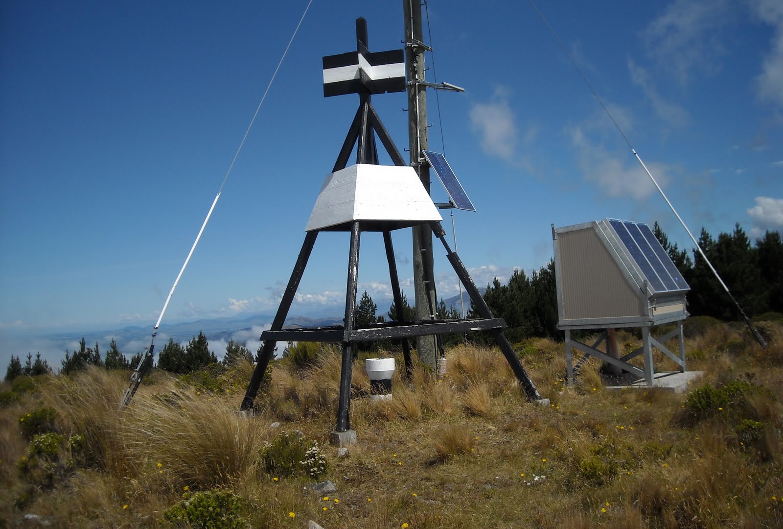
2010. Mt Thomas Summit, Trig Beacon, Aerial & Solar Panels
I wandered Mt Thomas summit, and coolpixed 360 degree views of clouds rising above Mt Thomas northern slopes; clouds covering Canterbury Plains and rising above Mt Thomas; and mist still creeping up Mt Thomas beech gullies from Canterbury Plains. Mt Thomas summit western views were clear to Torlesse Range and Puketeraki Range, cumulus clouds above the ranges.
On Mt Thomas summit, I coolpixed Celmisia Alpine daisies and low, white-flowering Hebe odora bushes, with bees pollinating hebe flowers. Mt Thomas summit was scented with Hebe odora fragrance.

2010. Mt Thomas Summit, Hebe odora & Celmisias

2010. Mt Thomas Summit, Hebe odora

2010. Mt Thomas Summit Hebe odora western view of Mt Thomas Summit Ridge, Wooded Gully & Southen Alps

2010. Mt Thomas Summit Hebe odora western view of Cloudy Southen Alps
2. MT THOMAS, RIDGE TRACK. My time, 1 hour: 30 minutes exposed summit ridge, 30 minutes beech forest from Mt Thomas summit ridge to Wooded Gully Track fork.

2010. Ridge Track, Mt Thomas Summit. Wooded Gully & Southern Alps backdrop
Ridge Track, along exposed Mt Thomas summit ridge, was well marked with DOC signs and fence standards with orange plastic tops. Leaving Mt Thomas pine forest, along the ridge I had glimpses of Canterbury Plains through cloud gaps. Early afternoon mist still swirled up Mt Thomas Wooded Gully. Westwards, I had clear views of more pine-forested gullies and clear views over Southern Alps.
On sunny, soggy Ridge Track I passed turpentine shrubs, Dracophyllum longifolium, tussocks, great mats of Alpine daisies, Celmisia sessiflora, and some windblown kanukas and beeches.

2010. Celmisia sessiflora & Dracophyllum longifolium, Ridge Track, Mt Thomas Summit

2010. Celmisias, Ridge Track, Mt Thomas Summit

2010. Ridge Track view of Mt Thomas Summit

2010. Lone Beech, Ridge Track, Mt Thomas Summit
Ridge Track went down steep, slippery rocks in humid beech forest, well marked with DOC signs and orange plastic triangles nailed to trunks. I would descend the humid beech gully for 3.5 hours. Mist left Wooded Gully extremely humid.
Beech trunks were blackened by fungi feeding on honeydew from sap-sucking scale insects. Wasps foraged honeydew too. A mouse scuttled down a blackened beech trunk. I wondered what it ate?

2010. Ridge Track, Mt Thomas Summit, descending to Beech Forest, Wooded Glen

2010. Dracophyllum / Beech Tree Line, Ridge Track, Mt Thomas Summit

2010. Celmisias, Hebe odora & Flax, Ridge Track, Mt Thomas Summit

2010. Start of Beech Forest, Ridge Track, Mt Thomas Summit

2010. Wasp on Sooty Mould, Beech Tree Bark, Ridge Track, Mt Thomas

2010. Beeches, Ridge Track, Mt Thomas

2010. Beeches & Understory, Ridge Track, Mt Thomas
Masses of ferns grew in beech understory, with luxuriant lichens and mosses growing on rocks, trunks and roots. Moist totara trunks shone russett in dappled understory.

2010. Ferns in Beech Understory, Ridge Track, Mt Thomas
3. MT THOMAS, WOODED GULLY TRACK. My time, 3 hours from Mt Thomas Ridge Track fork to Wooded Gully Picnic Area / Carpark.
In the beech forest, I came to a DOC sign at a Ridge Track fork which stated:
RIDGE TRACK <-
WOODED GULLY PICNIC AREA 3 hr
BOB'S CAMP BIVVY 3 hr
MT THOMAS SUMMIT -> 1 hr
WOODED GULLY TRACK
WOODED GULLY PICNIC AREA 2 hr

2010. DOC Sign, Wooded Gully Track, Mt Thomas

2010. Wooden Steps, Wooded Gully Track, Mt Thomas
The DOC employee who'd guesstimated times to the Wooded Gully Picnic Area via Ridge Track (3 hr) or Wooded Gully Picnic Area via Wooded Gully Track (2 hr) was a speed freak. I walked the last option in 3 hours, non-stop.

2010. Stream & Understory, Wooded Gully Track, Mt Thomas

2010. Beech Trunks & Russet Totara Trunk, Wooded Gully Track, Mt Thomas

2010. Slipppery Roots, Wooded Gully Track, Mt Thomas
The DOC sign I'd seen on Mt Thomas summit underestimated walking times too: No way could I descend Mt Thomas summit down Ridge Track, then Wooded Gully Track to Wooded Gully Picnic Area in 3 hours. I did it in 4 hours, hill-walking fit.

2010. Old Mans Beard Lichen, Beech Branch, Wooded Gully Track, Mt Thomas

2010. Leafy Lichen on Beech Trunk, Wooded Gully Track, Mt Thomas

2010. Crustose Lichens on Beech Trunk, Wooded Gully Track, Mt Thomas

2010. Leafy Lichen, Wooded Gully Track, Mt Thomas

2010. Crustose Lichens on Rocks, Wooded Gully Track, Mt Thomas
Wooded Gully Track took me mostly downhill through humid beech forest, past native trees, shrubs, mosses, lichens, fungi, ferns and fauna. Due to morning and early afternoon mists Wooded Gully Track was wet and slippery, so I had to watch every step of my way down wooden steps, over soggy leaf-litter, over slippery roots and rocks, crossing several streams and wooden footbridges.
I passed two recent mud slips with toppled trees and a fallen rock on the track. In hazardous spots with bad erosion, DOC had tied plastic warning tapes between trees.

2010. Horopito, Pepper Tree, Pseudowintera colorata, Wooded Gully Track, Mt Thomas

2010. Ferny Understory, Wooded Gully Track, Mt Thomas

2010. Crustose Lichen on Beech Trunk, Wooded Gully Track, Mt Thomas

2010. Wooded Gully Track Beeches, Mt Thomas

2010. Stream, Wooded Gully Track, Mt Thomas
Near Wooded Gully bottom, I passed three DOC signs showing shorter tracks off Wooded Gully Track viz: Red Pine Track... Forest Track... Kereru Track... While I descended, clouds lifted, giving me late afternoon glimpses of Canterbury Plains and Mt Thomas summit through beech canopy.

2010. Brown Bracket Fungus on tree trunk, Wooded Gully Track, Mt Thomas

2010. Lichens on Mossy Rock, Wooded Gully Track, Mt Thomas

2010. Wooded Gully Track, Mt Thomas

2010. Tree Fuchsia, Fuchsia excorticata & ferns, Wooded Gully Track, Mt Thomas

2010. Tree Fern in Beech Forest, Wooded Gully Track, Mt Thomas

2010. Dappled Wooded Gully Track, Mt Thomas

2010. Beige Bracket Fungus on Rotting Log, Wooded Gully Track, Mt Thomas

2010. Wooded Gully Track view of Wooded Gully, Mt Thomas

2010. Stream Picnic Site & Wooden Bridge, Wooded Gully Track, Mt Thomas
Near Wooded Gully Picnic Area / Carpark, I encountered trackside gorse and broom again. At the carpark my car was the only vehicle left with stinging sandflies. Other cars and campers gone. All day walking misty Mt Thomas tracks, I hadn't seen a soul.

2010. Wooded Gully Carpark, Mt Thomas

2010. Wooded Gully Carpark DOC Sign, Mt Thomas
On my late afternoon drive back to Christchurch, I stopped to coolpix Mt Thomas, which I hadn't seen in the morning mist.

2010. Mt Thomas, Canterbury
Post New Year 2013, Leah & I stayed at a friend's Oxford cottage & did a couple of walks on Mt Thomas lower slopes:
Thurs 03.01.13. Forest Track, from Wooded Gully Carpark, via pine plantation up the Summit Track a bit, crossed a forestry road, then at the next forestry road, took a left turn down a valley side through beech forest to a small waterfall & pool by a footbridge. Sandflies sucked. Returned through beech forest on the opposite valley side via Wooded Gully Track back to the carpark. Return time, about 2.5 hours. Return distance, approx 3 kms.
Fri 04.01.13. Red Pine Track, a big loop track from Wooded Gully Carpark, climbing about 2.6 kms up a valley side through beech forest. About half way up Mt Thomas, the track looped back through beech forest down the same valley side, via Wooded Gully Track. As creeks were crossed, sandflies were inevitable. Return time, about 3.5 hours. Return distance, approx 5.2 kms.

04.01.13. Red Pine Track turning, half way up Mt Thomas


Kereru Track, about 2.2 kms, 1 hour return, looped within Red Pine Track to & from the carpark.
Wooded Gully Track from the carpark continued from Red Pine Track turning point for another 2.6 kms up to Mt Thomas summit. One way time, about 3 hours. One way distance, approx 5.2 kms.

04.01.13. Wooded Gully Track, half way up Mt Thomas
As it was holiday season, campsite busy, there were other walkers on the tracks, some walking their dogs. After a pesky dog followed me up Red Pine Track from the carpark, I yelled, "Voetsak!" He did.
Content & pics Copyright Mark JS Esslemont.


