
2010. Road Signs near Amberley on the way to Mt Grey
As I wanted to climb Mt Grey (934m) in Hurunui district, one Friday I drove about 70 kms from Christchurch to Lake Janet in Ashley Forest, via Amberley, Douglas Road and Cramptons Bush Road, which became dirt road for about 17 kms through farm and forest hills to Lake Janet.
I wanted to do a circular day-walk from Lake Janet on a forestry road up Mt Grey; descend Mt Grey to Grey River; return to Lake Janet on forestry roads.
Caution: I climbed Mt Grey one hot morning, weather changed quickly on Mt Grey summit, and during my afternoon descent it rained. Hill walking fitness, water, food and weatherproof gear are needed.

2010. Cramptons Bush Road view of Mt Grey (934m)

2010. Cyanide & Fire Danger Signs, Cramptons Bush Road, Mt Grey
By a gate at the bottom of Mt Grey Forest, two signs stated:
CYANIDE
LAID FOR POSSUMS
THIS GATE WILL
BE CLOSED WHEN
FIRE DANGER IS
VERY HIGH
OR EXTREME

2010. Mt Thomas view from Lake Janet, lower Mt Grey slope
Regarding Sir George Grey, after whom Mt Grey was named, in the 1800s twice governor of NZ, once premier, and governor of the Cape Colony - my connections: I saw Sir George Grey's tomb in St Pauls Cathedral, London. My East London, Selborne College hockey teams played at Grey High School, Port Elizabeth and at Grey College, Bloemfontein. I had holidays at my aunt's home in President Reitz Laan, Bloemfontein, easy walking distance from Grey College.
I'd holidayed at Elandspruit farm near New Hanover, not far from Greytown. My brother had meningitis at Grey's Hospital, Pietermaritzburg, KwaZulu-Natal - all named after Sir George Grey.
I'd also trekked over the Southern Alps to Punakaiki, via West Coast's Grey River and Greymouth.

2010. Lake Janet Picnic Area Sign, Mt Grey
At Lake Janet carpark, I saw the fire lookout and transmitter on Mt Grey skyline. Westwards beyond Ashley Forest I saw distant Mt Thomas, also forested, and beyond to Canterbury Plains vanishing into haze. By Lake Janet Picnic Area sign another sign stated:
LIGHT
NO FIRES
NO
MOTORCYCLES

2010. No Fires, No Motorcycles Signs, Lake Janet
I crossed a duckboard bridge by Lake Janet, a misnomer pond, surrounded by gorse, broom, shrubs and plantings: Douglas firs, gums, willows, birches, beeches, Coprosma robusta, flax.
Sir George Grey would've enjoyed picnicking there, as he was a naturalist like Earl Selborne. In SA, Sir George Grey had unsuccessfully vouched for a Union of SA colonies and republics, which only came about in 1910 during Earl Selborne's tenure as SA High Commissioner.

2010. Lake Janet, Mt Grey
On the other side of Lake Janet, with eucalyptus scent wafting over me, I crossed a locked gate on the forestry dirt road which climbed to Mt Grey summit.

2010. Forestry Road, Lake Janet, Mt Grey
1. LAKE JANET TO MT GREY SUMMIT VIA FORESTRY ROAD. My time, 2 hours.
The forestry dirt road steeply climbed Mt Grey in a huge S, looping up Mt Grey eastern slopes through pine / beech forest; looping westwards through pine / beech forest to the fire lookout above the tree line; looping eastwards along Mt Grey summit slope through subalpine vegetation to the transmitter, where the dirt road stopped.
On my hot climb through pine forest, I saw hazy Hurunui hills to hazy Pacific. Lining pine forest roadside I saw gorse, thistles, broom, facelia, grass, yarrow, Coprosma robusta.
After about 20 minutes climb, I came upon cool beech forest, with an unmarked track leaving the roadside through wineberries and tree fuchsias by a small waterfall.
It took some minutes for my eyes to adjust from bright sunlight on the road to beech gully gloom. I didn't climb the beech gully, as it was too steep and dark.

2010. Fire Lookout seen from Mt Grey Forestry Road
Back on the forestry road, for a while I had beech forest on my left and pine forest on my right, with glimpses of Mt Grey Forest below and beyond to brown Hurunui hills, to hazy Pegasus Bay and distant Kaikouras Ranges. Behind I saw the fire lookout on a forested ridge crest.

2010. Mt Grey Pine Forest view of Mt Grey Forest, hazy Canterbury Plains & Pacific
Soon pine forest lined both sides of the dirt road. A forester and his smiley wife pulled up in their ute. "You're on the best way up," he said, then continued driving downhill. They were the only ghosts I saw on Mt Grey.
Higher up, the forestry road looped back past the beech gully, where a roadside sign stated:
QUEEN ELIZABETH 11
NATIONAL TRUST
PROTECTED
OPEN SPACE
(PRIVATE LAND)

2010. QE11 National Trust Sign, Mt Grey
Five months before, I'd seen similar National Trust signs at Mears Bush near Oxford. I passed another National Trust sign attached to a roadside red beech, Nothofagus fusca. The sign reminded me of my volunteer supervisor work on National Trust properties near Dorking and Seven Oaks, England.

2010. Mt Grey east slope view of Mt Grey Beech Forest & Mt Grey Summit
After about 1 1/2 hours slog up the forestry road, the road broke through the tree line above the fire lookout, where I stopped on the corner for a CocaCola cool off in the breeze.
I coolpixed views: northwards - forest, hazy Hurunui hills and Kaikouras; eastwards - forest, hazy Amberley and hazy Canterbury Plains to hazy Pegasus Bay; southwards - forest, hazy Canterbury Plains (too hazy to see Christchurch and Banks Peninsula), Mt Thomas, hazy Mt Oxford; south-westwards - hazy Torlesse Range, hazy Puketeraki Range.
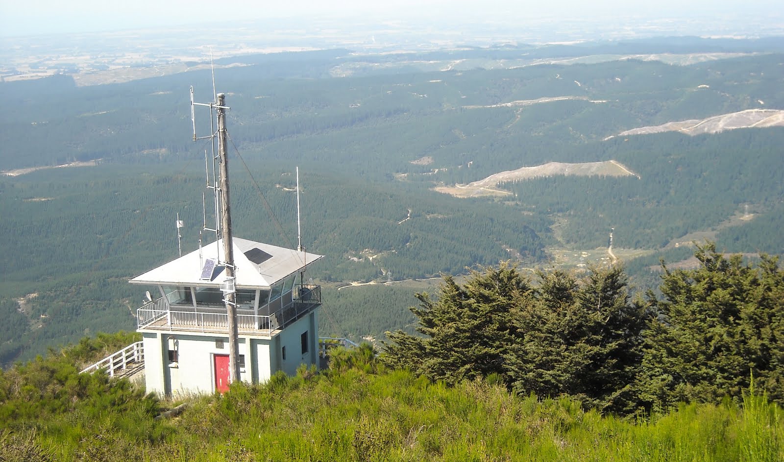
2010. Fire Lookout, below Mt Grey Summit

2010. Fire Lookout view of Mt Grey Forest & hazy Canterbury Plains
For the next 1/2 hour the dirt road sidled gently up the west slope of Mt Grey summit, (I ignored an unmarked track along the summit crest), through dry subalpine vegetation: tussocks, scrubby kanukas, white-flowering hebes, matagouri, flax, broom, celmisias.
I watched two Australian harriers soaring above western beech ridges, with magnificent views of Puketeraki Range.

2010. Fire Lookout view of Mt Grey Forest, hazy Canterbury Plains & Mt Thomas

2010. Mt Grey Summit Hebe odora view of Mt Grey Forest, Mt Thomas & Puketeraki Range
2. MT GREY TRACK: MT GREY SUMMIT TO GREY RIVER PICNIC AREA. My time, 2 1/2 hours.

2010. Mt Grey Summit view of hazy Canterbury Plains & Mt Thomas

2010. Mt Grey Summit Road view of hazy Canterbury Plains & Mt Thomas

2010. Summit Transmitter, Mt Grey Summit (934m)
Below the big transmitter on Mt Grey summit, I coolpixed eastern views over hazy Canterbury Plains & western views over hazy Mt Thomas, Mt Oxford, Southern Alps.
I walked towards Mt Grey survey beacon along the narrow summit saddle, with Mt Grey eastern slopes dropping to pine forests on rounded hills, and Mt Grey western slopes dropping to beech forests on steep ridges.

2010. Mt Grey Summit view of Hurunui Hills & Pacific

2010. Mt Grey Summit view of Hurunui Hills

2010. Mt Grey Summit view of Hurunui Hills

2010. Mt Grey Summit Ridge view of Summit Beacon
On the rocky, windy saddle between Mt Grey transmitter and summit trig beacon, I found three wooden signs arranged in a triangle:
LOOKOUT 30 mins ->
GREY RIVER
PICNIC AREA 2-3 hours - >
RED BEECH TRACK 2-3 hours ->

2010. Mt Grey Summit Ridge Signs between Summit Beacon & Summit Transmitter
Red Beech Track went down a gully through dry subalpine vegetation, then beech forest, to Grey River Picnic Area.
I would descend Mt Grey Track below the dirt road on Mt Grey summit, then continue along a dry subalpine ridge to beech forest going down to Grey River Picnic Area.
At the signs I stopped for lunch: apple, ham and lettuce sarmie, muesli bar, CocaCola. I tried to text Leah. No good: Like on Mt Thomas, Mt Richardson, Mt Oxford summits, despite the big transmitter atop Mt Grey I was out of texting range.

2010. Mt Grey Dry West Slope view of Mt Grey Summit Transmitter

201o. Golden Spaniard, Aciphylla aurea, Mt Grey Summit west slope

2010. Beech Forest, Mt Grey Western Slopes

2010. Mt Grey Track Hebe odora western view of Mt Grey Forest & Mt Thomas
While saddle winds cooled me, and while distant haze swiftly changed to clouds, I thought of ancient Maori regarding Mt Grey / Moukatere (Floating Mountain) as the place where Maori ghosts gathered on the South Island for their trek to the North Island and Cape Reinga, where Maori ghosts went to their underworld.
I felt nothing supernatural on Mt Grey summit, but I'd been spooked in the mist weeks before on Mt Thomas. Maybe Maori ghosts lost their way on Mt Thomas? I wondered why Maori ghosts hadn't gathered on higher Alpine peaks?

2010. Matagouri Thorns, Mt Grey Track

2010. Mt Grey Track view of Mt Grey Summit

2010. Aciphylla aurea & Hebe odora, Mt Grey Track

2010. Apple & Prickly Mingimingi, Leptecophylla juniperina, Mt Grey Track

2010. Mt Grey Track view of Mt Grey Forest & Mt Thomas

2010. Prickly Mingimingi, Leptecophylla juniperina, Mt Grey Track
For about 1/2 hour I wandered through dry subalpine tussock with views of Canterbury Plains and Mt Thomas ahead; Mt Grey western slopes dropping to beech gullies, with views of beech ridges and Puketeraki Range beyond.
I passed white-flowering hebes, matagouri, golden Spaniards, Aciphylla aurea, with their maces of spiky leaves. I saw bush snowberries, Gaultheria antipoda, their red berries bright against brown tussocks.

2010. Beech Forest, Mt Grey Track

2010. Bush Lawyer, Rubus cissoides, Mt Grey Track

2010. Bush Lawyer Berries, Mt Grey Track

2010. Orange Marker on Beech, Mt Grey Track

2010. Mt Grey Track Beeches & Undergrowth

2010. Mt Grey Track Beeches

2010. Snowberry, Gaultheria antipoda & Wasp, Mt Grey Track
Mt Grey Track, zigzagging down beech forest, was well marked with orange plastic triangles nailed to trees. I crossed a trickling stream, and through beech canopy I had glimpses of Mt Thomas and Mt Oxford on my right, and on my left glimpses of Canterbury Plains.
An hour into the beech forest, it began to rain, so I had dripping beeches and dripping understorey thereafter. In places Mt Grey Track was muddy, with track churned by MTB tyres. I passed a sign:
<- MT GREY TRACK VIEWPOINT 5 mins ->

2010. Karaka, Corynocarpus laevigatus, Mt Grey Track

2010. Soft Mingimingi, Leucopogon fasciculatus, Mt Grey Track

2010. Soft Mingimingi & Prickly Mingimingi, Leptecophylla juniperina with red berries, Mt Grey Track
Mt Grey Track was rocky with lots of cracked stones beside the steep track. In the beech understorey I passed broadleafs; lancewoods; lophomyrtus; bush lawyers with bunches of orange / red berries; scrubby kanukas; wineberries; coprosmas; horopitos; karakas; matipos; rimus; masses of mosses, lichens and ferns like blechnums; silver ferns; five-fingers; tree fuchsias; red-berried mingimingis, Leptecophylla juniperina, with small, spiky leaves.

2010. Snowberry, Gaultheira antipoda showing serrated margin leaves, Mt Grey Track

2010. Hounds Tongue Fern, Phymatosorus pustulatus on Lichen Rock, Mt Grey Track

2010. Bracket Fungus on Trunk, Mt Grey Track

2010. Pines in Beech Forest Glade, Mt Grey Track

2010. Duckboard Through Beeches, Mt Grey Track

2010. Tree Fern & Schefflera digitata in Beech Forest, Mt Grey Track

2010. Wooden Footbridge over Grey River in Beech Forest, Mt Grey Track
In glades on my way down I encountered inevitable gorse, and near the valley bottom I crossed 5 duckboard footbridges through dark, dripping beeches, crossed a wooden footbridge over Grey River, then another duckboard footbridge, and a curved boardwalk, before reaching the dirt road going over Grey River on a concrete causeway. By the road a sign stated:
MT GREY TRACK
2-3 hours

2010. Mt Grey Track Sign near Grey River

2010. Grey River above Ford & Picnic Area

2010. DOC Map, Grey River Picnic Area

2010. Grey River Picnic Area Info Board
At Grey River Picnic Area, I coolpixed the DOC map board and info board, and looked at more signs:
RED BEECH TRACK TO SUMMIT 4-5 hours
NATURE TRAIL 1 hr ->

2010. Nature Trail Wooden Steps, Grey River Picnic Area
I explored the beech forest picnic area, then walked up the steep dirt road past two Nature Trail entrances into beech forest, till I reached a locked gate forbidding me entering a forestry area. I coolpixed forested Mt Grey with cloudy summit, then returned to the picnic area.

2010. Okuku Road view of Misty Mt Grey
3. GREY RIVER PICNIC AREA TO LAKE JANET. My time, 1 1/4 hours.

2010. Beehives in Beech Forest, Okuku Road
From Grey River Picnic Area, I walked up Okuku Road, a forestry dirt road, with pine forest both sides of Okuku Road, and beehives stacked in four places beside the road. I passed roadside gorse and broom, and where Okuku Road joined Mt Grey Road near another locked gate, I passed another sign:
GREY RIVER PICNIC AREA ->

2010. Mt Grey Road view of Misty Mt Grey

2010. Wineberry, Aristotelia serrata, Mt Grey Road

2010. Tree Fuchsia, Coprosma & Schefflera, Mt Grey Road
While I slogged up Mt Grey Road to Lake Janet, mist still covered Mt Grey summit and crept down beech valleys. I wondered whether Maori ghosts had swirled up there?
I passed pine patches and beech patches beside misty Mt Grey Road, and on the disturbed roadside I coolpixed dripping wineberries, tree fuchsias, scheffleras, coprosmas, kanukas, sedges, hebes, toetoes, tutus, bush lawyers. Sir George would've approved.

2010. Schefflera, Ferns & Gorse, Mt Grey Road

2010. Tutu, Coriaria arborea, Mt Grey Road
In mid winter I drove Leah to Mt Grey, where snow speckled Mt Grey summit above the tree line. By Lake Janet, deciduous larches had lost their needles, and the green Lake Janet sign was missing. Four young men, hunters with rifles left Lake Janet picnic area when they saw us, and drove down Mt Grey Road. Leah and I walked round Lake Janet in 5 minutes, then had tea in our Honda Civic.
On our drive down to Grey River, I had to watch out for icy potholes on icy Mt Grey Road. A winter storm had strewn young pines beside the dirt road. The hunters' empty blue car was parked at Mt Grey Road / Okuku Road fork. Road gates were locked, so we turned back.
At Lake Janet again, we enjoyed clear views across Mt Grey Forest, Hurunui Hills, Canterbury Plains, Pegasus Bay, Port Hills and Banks Peninsula. We admired forested Mt Thomas and snowy Puketeraki & Torlesse Ranges. On our drive back to Amberley, we glimpsed snowy Kaikouras Ranges through Hurunui Hills.
Content & pics Copyright Mark JS Esslemont
See Australasian Harrier
Email exchange with a Durban North, Northlands Boys High School mate, USA expat, who I did SADF commando basic with at Danie Theron Combat School, Discobolos, Kimberley, SA, in July 1969. We were inoculated with anti-tetanus & other unknown injections during our basic camp. Emails resulted from my email comment about Christchurch, NZ verge spraying with unknown poisons:
ReplyDeleteMate: "Geez Mark, that poison spraying doesn't sound too good. Do they inform you when they are about to spray? They spray for West Nile here but they have to call and let us know when they are spraying and they also have a web page with the info posted. The dumb ass told me when I was inquiring as to what they were using for pesticide that they never had a case of W. Nile in Florida and only one confirmed in the whole USA, in Colorado. Go figure! Must be us that they are trying to kill. Kinda reminds me of Discobolos..."
Me: "Ja Discobolos revisited: Dunno if Christchurch Council must warn us re spraying. We've never been warned. I just see their trucks floating around Chch spraying willy nilly: leaves sprayed grass brown, bright orange (dioxin?) or maroon, depending on the poison sprayed. NZ was one of the countries to supply dioxin (agent orange) to USA during the Vietnam War (Kiwis fought in that war too): even had a dioxin plant nr New Plymouth, N. Island, which left babies deformed over the yrs due to gas escape / mutations during pregnancy, etc. Plant closed now.
NZ has a trad of spraying, poisoning, cow shit in rivers, human shit in rivers & sea. Poisoners try to kill vermin like possums, stoats, rabbits, which gobble farmland, eat introduced poultry & destroy beech forests. Maori killed off moas by burning forests. Later Pom settlers killed off most of the rest of NZ wildlife esp birdlife, by intro of stoats, rabbits, possums, red deer, etc. Kiwis, kakapos, etc are all flightless birds, so can't escape predators. We have a fenced bush, Deans Bush in Chch with a fence dug into the ground to stop predators preying on native birds, just like keeping troopies gaoled in Danie Theron eh?
Kiwis are a bit like SA wildlife, only survive in game sanctuaries. I've never seen a live kiwi in the wild - only in protected bird sanctuaries. Some human Kiwis make a living as poisoners of farmland & forests. I often see warning signs re 1080 poison or cyanide on farm fences to poison rabbits & possums, or see traps for stoats. Apparently the high country is riddled with Himalayan thar, chamois & red deer, all introduced by Poms in the 1800s. Hunters enjoy shooting them. And exotic ducks like mallards, & Canada geese, outnumber native ducks. Recently Didymo rock snot invaded rivers, a mean alga which covers rocks & clogs streams, rivers & boating apparatus.
Despite 'clean green' tourist image, NZ is a mess as far as weeds & vermin goes. Lots of plant invaders too e.g. gorse, broom, Californian thistle & of course some lekker SA plants like bone seed (dune plant with yellow flowers), iceplant (Hottentots fig which hybridises with a NZ iceplant), Senecio elegans - purple Cape daisy, geraniums, cotyledons, etc, which I see on my walks: all garden escapes. So plants, SA's & other nations', emigrated to NZ long before us post-apartheid migrants."
Responded to an email from a SA, East Londoner, inquiring about walks in the Rangiora - Oxford vicinity.
ReplyDelete