Due to "upmarket" housing developments over the years, it was impossible to drive hill lanes in sequence, as most lanes were no-exit & partly housed Challenger Ln was lower on the hillside, only approachable from Redcliffs Main Rd via Egnot Hgts. Higher & lower lanes were connected by 150+ Mary Gregg Steps. Many houses were red-stickered. There were other steep hillside & hilltop lanes, but those were enough horrors for one sunny day.
Parked near the top of Glenstrae Rd, I saw snowy Alpine views beyond Canterbury Plains. On Balmoral Hill where I stood, the sky was clear blue, but Christchurch below gasped in smog, caused by a temperature-inversion & winter fires.

02.08.11. Glenstrae Rd view, smoggy Christchurch on Canterbury Plains, Southern Alps beyond. Avon-Heathcote Estuary below, post June 13 quake

So much for EQC's scheme to replace quake-damaged chimneys & fireplaces with new heating units! EQC could blame smog on liquefaction-dust. EQC boasted in The Press 30.07.11: "Installed and ordered more than 25 000 heating units under the winter heating programme to the most vulnerable homes in Christchurch." Christchurch's smoke-pollution was an annual wintry whinge in the media. Would CERA demolish those "vulnerable homes"?

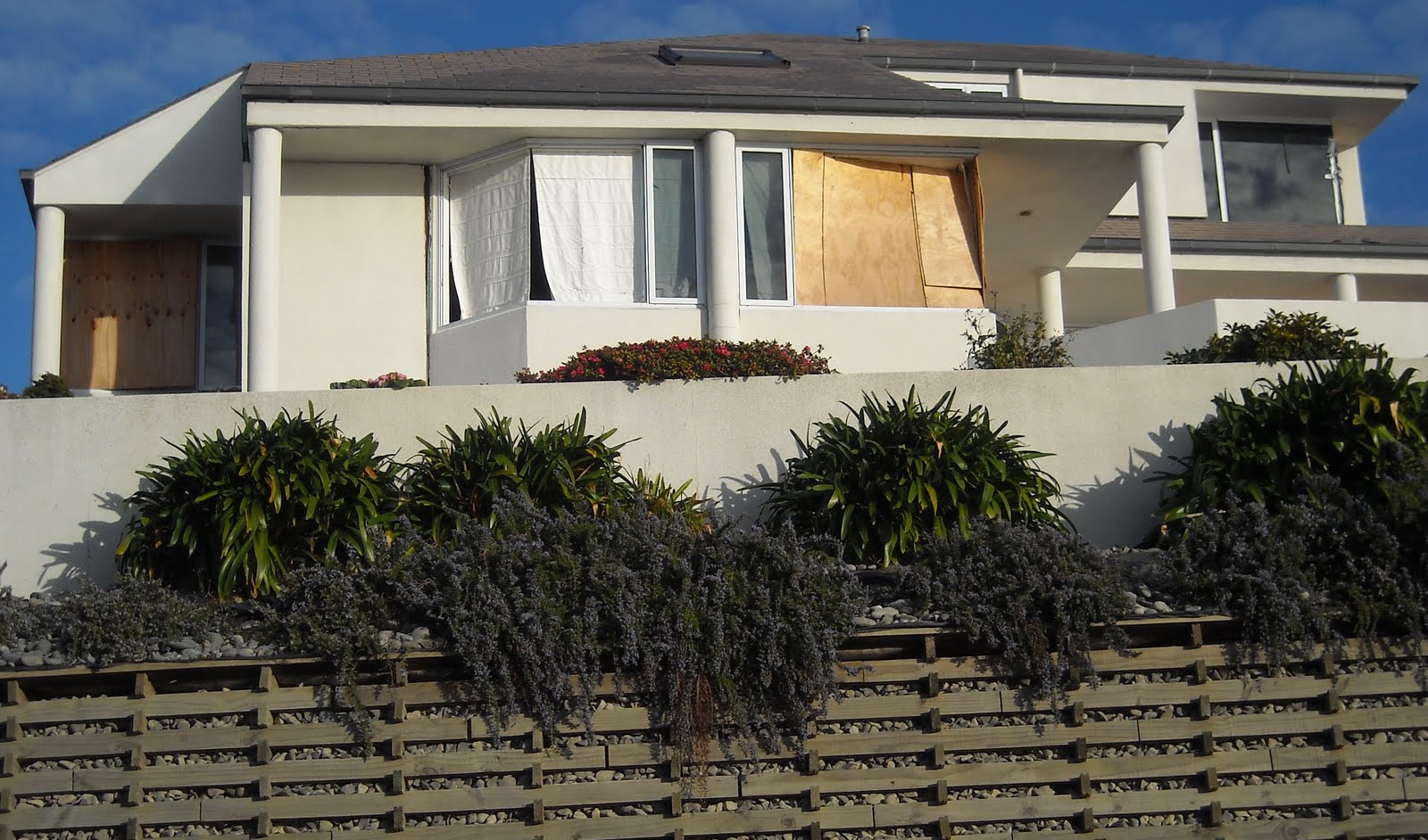
02.08.11. Quake damaged, boarded, tarped house, Glenstrae Rd / Glendevere Tce, post June 13 quake


02.08.11. Quake damaged house, Glendevere Tce, post June 13 quake. C meant Clear no bodies, USAR / TF

02.08.11. C meant Clear no bodies, USAR / TF. Quake damaged house, Glendevere Tce, post June 13 quake

02.08.11. Glendevere Tce view, Redcliffs suburb, Avon-Heathcote Estuary, Southshore Spit, quake collapsed Shag Rock, Pacific, Clifton, Moncks Bay, post June 13 quake
Quake-damages above Redcliffs, parallel Glendevere Tce & Dunkeld Ln: Cracked-roads & cracked-footpaths; broken retaining-walls; blue-plastic-water-pipes exposed on roadsides; boarded ghost-houses on slippery slopes; roadside portaloos; a black, polyethylene sewage-pipe roadside, a pile of waste carpets by Balmoral Hill Reserve. There was little quakemire on the heights, but many cracks.

02.08.11. Quake damaged, retaining walls, odd numbered Glendevere Tce houses, post June 13 quake


02.08.11. Quake cracked house, Glendevere Tce, post June 13 quake


02.08.11. Quake damaged carpets, Balmoral Hill Reserve, Glendevere Tce, post June 13 quake

02.08.11. Quake damaged Glendevere Tce, post June 13 quake
Glendevere Tce: Even-numbered ghost-houses teetered atop Redcliffs, awaiting house-fall. Most were red-stickered, but CERA's geotech stooges would take months to map the cliff-top as red-zone before any demolitions could happen.

02.08.11. Quake trashed, even numbered, Glendevere Tce house, Redcliffs edge, post June 13 quake


02.08.11. FOOTPATH CLOSED. Orange, plastic, road cone cordon. Blue, plastic, water pipe. Quake damaged Glendevere Tce, Redcliffs edge, post June 13 quake

02.08.11. Quake damaged, even numbered house, Glendevere Tce, Redcliffs edge, post June 13 quake

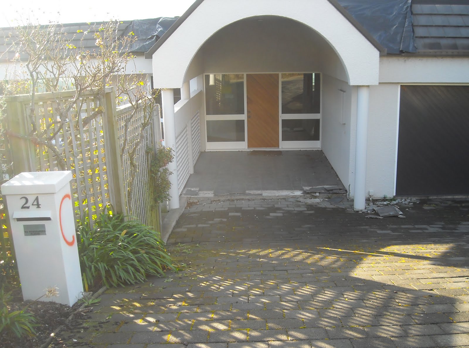
02.08.11. C meant Clear no bodies, USAR / TF. Quake damaged house, Glendevere Tce, post June 13 quake


02.08.11. Glendevere Tce view, Redcliffs suburb, Avon-Heathcote Estuary, Southshore Spit, quake collapsed Shag Rock, Pacific, Clifton, Moncks Bay, post June 13 quake

Hillside lanes atop Redcliffs were quake-shaken. Quiet. Few cars, few people. Some houses were empty, rubbish in gardens, household items & furniture was strewn in rooms. Lovely hillside houses, spectacular views of Avon-Heathcote Estuary, Southshore Spit, Moncks Bay, collapsed Shag Rock, Pacific.

02.08.11. Bench plaque, Dunkeld Ln, post June 13 quake

02.08.11. Orange portaloo, Dunkeld Ln, post June 13 quake

02.08.11 Quake broken garden wall, Dunkeld Ln, post June 13 quake

02.08.11. Dunkeld Ln view, quake damaged Glendevere Tce house. C meant Clear no bodies, USAR / TF, post June 13 quake
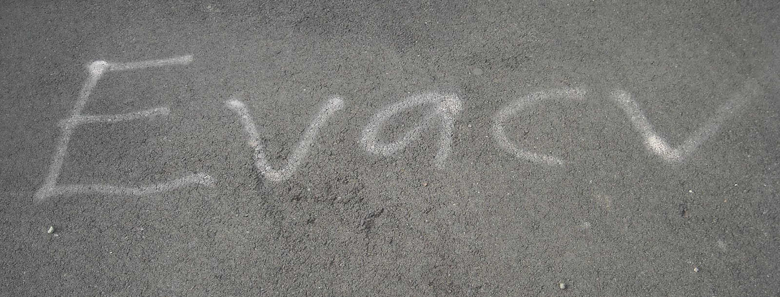
02.08.11. USAR / TF graffito, Glendevere Tce pavement, post June 13 quake
A rocky road-cutting at Redcliffs View Ln: Ghost-houses with spectacular views; fallen garden-wall; cracks in the road-cutting; DANGER plastic-taped-decking on a steep slope; cracked-road; few cars; few people.

02.08.11. Quake trashed garden wall, Glenstrae Rd / Redcliffs View Ln, post June 13 quake


02.08.11. Quake tilted lamp pole. Quake damaged housing, Redcliffs view, Redcliffs View Ln, post June 13 quake


Mary Gregg Steps: Shaky-houses both sides, more than 150 concrete-steps down to Defender Ln, a no-exit lane. A picture-window was popped off an unstable wood-braced, ghost-house wall at lane's end.

02.08.11. Mary Gregg Steps, Redcliffs View Ln, post June 13 quake

02.08.11. Mary Gregg Steps, quake damaged housing between Redcliffs View Ln & Defender Ln, post June 13 quake


02.08.11. Redcliffs cliff top, quake damaged, boarded house, seen from Defender Ln, post June 13 quake

02.08.11. Quake damaged house, Defender Ln, post June 13 quake


02.08.11. Defender Ln view, Redcliffs, Avon-Heathcote Estuary, Southshore Spit, Pacific, quake collapsed Shag Rock, Clifton, Moncks Bay, post June 13 quake

02.08.11. Quake damaged housing, Defender Ln, post June 13 quake


02.08.11. Quake damaged housing, Defender Ln / Challenger Ln, post June 13 quake

Challenger Ln: Ghost-houses: broken; cracked-walls; scattered rubble; loose roof-tiles; conked-roofs; warped garage-doors, fallen garden- wall; fallen retaining-wall; cracked-road. Pole sign:
REDUCE
SPEED

02.08.11. Quake damaged house, Challenger Ln, post June 13 quake


All the lanes I trekked had red C lettering spray-painted on walls or footpaths, showing USAR / TF teams had checked houses were clear of live or dead bodies. Some houses were red-stickered. Blue-plastic-water-pipes lined lanes. Someone had pink spray-painted LEAKS!! on a footpath.

02.08.11. Quake damaged housing, Challenger Ln, post June 13 quake


Challenger Ln: I snapped ghost-houses on the hillside below me: shattered bricks peeled off a new house; brick-wall peeled off an older house; roof-tiles shaken off houses; house-walls were boarded; two orange, Hi-Vis vested, building inspectors, with clipboards, skulked on a house-decking, when they saw me snapping above them.

02.08.11. Quake damaged housing & 2 orange, Hi-Vis vested, bldg inspectors, Challenger Ln, post June 13 quake


They didn't know my Nikon's liquid-crystal display was kaput. They scarpered, hiding behind another ghost-house. I would return another day to complete my Challenger Ln pics. My digital Nikon Coolpix-camera lasted only two and a half years. My trekking over rubble, grey quakemired-roads & through clouds of dust aged the camera quickly. I would also go through two new Samsung digital-cameras, also prematurely aged, before my quake-trekking finished at the end of 2013.

04.08.11. Quake damaged house, Challenger Ln, post June 13 quake


My heart pounding, I returned to my car up 150+ Mary Gregg Steps. A bloke jogged past panting, "I'm going up & down ten times!"
Via Moncks Spur Rd, I drove to Redcliffs Main Rd: the 13 June 2011 Quake caused more rockfalls, on 22 February 2010 Quake rockfalls, leaving massive rock-fans below Redcliffs. Main Rd: I passed New World supermarket's demolition-site. The supermarket would be rebuilt.
I drove up Egnots Hgts past a collapsed concrete retaining-wall, orange-plastic-road-cone-cordoned. I drove Challenger Ln which I'd already walked. I drove to Main Rd again past a house demolition-site near Redcliffs School.

04.08.11. Orange, plastic, road cone cordon. Quake collapsed retaining wall, Egnot Hts, post June 13 quake


Last time I'd passed after the 22 February 2011 Quake, Redcliffs School had reopened after quake-closure, shipping-containers protecting the school from more rockfalls. This time, a closed school-gate & a sign:
REDCLIFFS
SCHOOL
IS TEMPORARILY LOCATED AT
SUMNER
SCHOOL
Another sign:
SCHOOL
CLOSED
DO NOT
ENTER

04.08.11. Quake closed Redcliffs School & quake damaged Redcliffs, cliff top houses, Main Rd, post June 13 quake


Post 13 June 2011 Quake & rockfall dangers, Redcliffs School relocated to Sumner School for a couple of months, before relocating to Van Asch Deaf Education Centre, Sumner. Deaf pupils had moved on from their big school-grounds.
2015. Redcliffs School would still be at Van Asch. MoE minister Parata would refuse to reopen Redcliffs School, despite locals considering Redcliffs School safe.
Like Redcliffs School, several schools were disrupted by quakes, combining with other schools for a couple of years. 2012: MoE would disturb education with its botched plan for closures & mergers of several Christchurch schools. MoE wouldn't bother to consult school staffs & communities & tried its closure / merger coercion without even using census figures, as the 2011 census was postponed due to quakes. MoE predictions about school numbers post-quakes were guesswork, due to population shifts in Christchurch!

04.08.11. Main Rd view, Redcliffs quake damaged, cliff top houses, post June 13 quake


In 1995, after our emigration from RSA, our sons started school at Sumner, where we'd rented a house at Denman St. Post-quakes driving on Main Rd, I could see Glendevere Tce, teetering atop Redcliffs, ghost-houses awaiting falls or demolitions.

04.08.11. Quake damaged Redcliffs housing, Main Rd, post June 13 quake


04.08.11. Steel mesh fence cordon, orange, plastic, road cones, shipping containers (covering Moa Bone Point Cave) protecting traffic against Redcliffs rock fall & house fall, Main Rd, post June 13 quake. The clifftop house would be demolished

Moncks Cave, still a rubble-dump near New World demolition-site. Moa Bone Point Cave was orange-plastic-road-coned, two-layer shipping- container cordoned, protecting traffic from Redcliffs rockfalls & house-falls. The ghost-house above the cave would be demolished. Opposite the cave, another demolition-site.

04.08.11. Quake collapsed house wall, Main Rd, post June 13 quake,
*Trekked Glenstrae Rd, Glendevere Tce, Dunkeld Ln, Redcliffs View Ln, Mary Gregg Steps, Defender Ln, Challenger Ln, Egnot Hts, Main Rd. 118 snaps.
When I checked CERA's Landcheck website, Redcliffs hillside roads I trekked were all white-zone, "hillside suburb mapping still underway," leaving all those ghost-houses & families in limbo, 11 months post 4 September 2010 Quake & more than five months post 22 February 2011 Quake.
A week later, Monday 08.08.11, The Press featured a steep walk up Redcliffs including Egnot Hts, Challenger Ln, Glenstrae Rd, Glendevere Tce, Balmoral Reserve. Journalists got ideas from bloggers. It wasn't the first time I experienced the relationship: bloggers led, journalists followed.
11.08.11. The Press front page headline: "Rockfall risk means 150 Port Hills homes likely to be abandoned". The Press reported experts spouting rockfall risks. Pity their gobs were closed before cliff-top houses were built!
12.08.11. Near Leah's Jean Seabrook Memorial School, a 22 February 2011 Quake damaged & 13 June 2011 Quake trashed section of Richmond Working Mens Club, London St, was part-demolished over the last week. Leah said whenever a digger bashed, or a dump-truck rumbled by, the whole school shook, leaving staff & kids anxious. Noisy demolition-vibrations felt like aftershocks, the last thing staff & kids needed after surviving major shakings, joltings & liquefactions of the school during those quakes. It took more than five months for the Club & demolishers to act. Meanwhile, London St was poorly repaired, potholed & bumpy. A steel-mesh-fence-cordon by the Club obstructed busy traffic at Stanmore Rd corner.
Sun 13.08.11. I helped Jake relocate again, his fourth move in six months post 22 February 2011 Quake, to a comfy two-bedroom flat in Geraldine St, near the CBD. Grey-quakemire still muddied places post 13 June 2011 Quake, roads were still damaged, like nearby Packe St & Purchas St, where manholes were raised by quakes.
Eight sucker-trucks were parked on Geraldine St, awaiting sewage-sucking the next week. One sucker-truck's registration: SLURP. Holed up in motels for the weekend, sucker-truck operators slurped a fortune out of sewers clogged with quakemire & shit, which they dumped at Burwood Dump. Trouble with post-quake contractors: Many heavy-duty vehicles on Christchurch roads, taking up parking space, obstructing traffic, causing wear & tear on already damaged roads. Due to infrastructure renewals, excavations, road patching, heavy vehicles, the next few years would see Christchurch roads degrading, not improving.
That night it started snowing again. It snowed intermittently for two days, NZ polar-blasted.
Christchurch Council's Draft Central City Plan for the CBD was released over the past week. The Plan had loads of waffle, pretty pictures, maps, drawings, little on the fact Christchurch CBD was trashed by quakes, with draft planning to rebuild on quaked-swampland. Nice idea Avon River Park, but minimal, not extending to Avon-Heathcote Estuary.
Council's Draft Plan presumed acceptance by Christchurch citizens, who were forbidden seeing CBD extensive damage themselves, before it was demolished & sanitized, destroying evidence of previous poor planning & building. The Plan was released while the CBD was still NZDF-cordoned & CERA-occupied, six months post 22 February 2011 Quake & nearly a year post 4 September 2010 Quake.
Council's Draft Plan for Christchurch CBD would be swallowed whole by CERA's Blueprint for Christchurch CBD, concocted over 100 days. CERA's meddling in Council affairs would continue for five years!
Content & pics Copyright Mark JS Esslemont.
See Cliff top properties judged risk to life (The Press / Stuff Co).
No comments:
Post a Comment