Besides violent shaking throughout Christchurch & rockfalls in the Port Hills, along Avon River & Heathcote River, liquefaction had flooded riverside & swamp-suburbs. Given the volume of ground-water forced above ground & quakemire produced, XL quakes slumped riverbanks, or raised riverbeds & raised or lowered estuary beds returning swamp-suburbs back to swampland. That was nasty for anyone owning property on "reclaimed" wetlands, riversides & coastal dunes.
My 10 Bridges day: Avon River was swollen by recent rainfall. The same rainfall pattern pre 22 February 2011 Quake which caused so much liquefaction-damage.
Driving downriver, during many pic stops, I bumped along ruined & patched roads: River Rd, Dallington Tce, Locksley Ave, New Brighton Rd, Owles Tce, Union St, Estuary Rd. There was scant improvement to eastern suburb roads since the 22 February 2011 Quake a year before. Council still had much work to do on infrastructure repair & rebuild. (2016, roads would still be crap!)
Like the four CBD bridges I'd recently seen, eight concrete-bridges further downriver had strong spans unscathed by quakes. (Except for two ruined footbridges, one concrete, one steel). Two concrete bridges were two span, the rest downriver were three span, as Avon River widened towards Avon Estuary.
I saw damages at concrete-joins between bridge-abutments & bridge-spans, where span / abutment movement happened. Some spans banged against abutments, some moved sideways, some horizontally-rotated, some spalled concrete-chunks at joins. Some concrete-abutments either sunk into river mud & / or splayed at odd angles away from bridge-spans.
Damage clues: acute angle gaps between span-ends & abutments, with abutments skewed from the vertical; split steel-handrails at odd angles, skewed from the vertical, especially at abutment-joins; tilted light-poles & light-plinths on bridges; mangled or displaced rubber-linings at bridge / road joins, or below spans; spalled concrete-curbs & concrete-footpaths; cracked or buckled tarseal.
Stanmore Rd Bridge: Concrete, two span. Spans OK. Stone light-plinths were cracked, one fallen Avonside Dr side. Tilted abutment River Rd side.

15.02.12. Quake trashed, abandoned house, River Rd, nr Stanmore Rd Bridge

15.02.12. Quake tilted power pole. Stanmore Rd Bridge, quake damaged light plinth, Stanmore Rd / River Rd


Stanmore Road Bridge, a bronze-plaque:
STANMORE ROAD BRIDGE
In pre-European times the Avon, then known as Otakaroro, was at this point the boundary between two families within the Ngai Tahu tribe. The swampland adjacent to the bridge site provided highly prized foods for the local Maori.
In the early days of European settlement the Avon and Heathcote rivers were used as vital shipping access to the infant City of Christchurch. Bridges were regarded as a nuisance and their construction was discouraged outside of the city boundaries.
The first Stanmore Road Bridge was built on this site in 1862 and largely ignored ships statutory navigation rights. As a result in 1865 part of the bridge was cut away by Mr John Mills and his men to allow his steamer 'Maid of the Avon' to pass.
By 1875 the bridge was in a state of bad repair and in 1878 a new bridge was constructed with a 6ft path each side of a 24ft carriageway. Since then the bridge has been further widened and strengthened over the years.
By 1995 the old bridge had reached the end of its economic life and was replaced by the present bridge. The stone facing on the wing walls and the light support columns are built from materials recycled from the old bridge.
As Leah's London St, Seabrook Mckenzie Centre, teaching work was near Stanmore Rd Bridge, during our early Christchurch years, we saw bridge rebuild progress whenever we drove past on Avonside Dr.
Many Avon River bridges had abutments sunk or tilted so far into river mud that bridge spans were above abutment level. That caused a ski-jump effect where vehicles had to slow down before the bridge or on the bridge to carefully negotiate the drop / rise either side of the bridge. If one raced across a damaged bridge the vehicle's sump & exhaust could be gutted. Never mind potholes, sinkholes, cracks, lumps, bumps on roads.


15.02.12. Stanmore Rd Bridge, quake damaged abutment, collapsed light plinth, Stanmore Rd / Avonside Dr.
Despite patches along Avonside Dr towards Linwood Rd, slumping / cracking by Avon River was still happening a year post 22 February 2011 Quake. More road-patching was required. Post-quakes, wherever one drove in Christchurch there were detours, as road-works progressed or regressed. Avonside Dr / Linwood Rd / Woodham Rd was still a mess with a detour away from Linwood Rd, as water-pipes still needed attention a year post 22 February 2011 Quake.


15.02.12. Avonside Dr view, quake damaged Stanmore Rd Bridge
Swanns Rd Bridge: Concrete, two span. Spans OK. One concrete-abutment River Rd side had a big crack with rebars exposed & rusting. The opposite abutment was spalled at the span-end, Avonside Dr side. (2022. Abutment & rusty rebars were still exposed, no concrete-patch on the rebars!)

15.02.12. Quake tilted power pole. Quake slumped footpath, Avon River bank, Swanns Rd Bridge, Swanns Rd / River Rd


15.02.12. Swanns Rd Bridge, quake cracked abutment, exposing rebars, Swanns Rd / River Rd. 2022. Rebars still exposed a decade later!


15.02.12. Swanns Rd Bridge, quake cracked / slumped pavement & abutment, Swanns Rd / River Rd

15.02.12. Swanns Rd Bridge view, quake trashed, abandoned housing, Avonside Dr. Post quake, blue water pipe on post quake, patched pavement. The houses would be demolished


15.02.12. Swanns Rd Bridge, quake spalled join between abutment & span, Swanns Rd / Avonside Dr

15.02.12. Swanns Rd Bridge, quake displacement of abutment & bridge span, road deck, Swanns Rd / Avonside Dr

15.02.12. Swanns Rd Bridge, spalling between span & abutment, Swanns Rd / Avonside Dr

15.02.12. Avonside Dr downriver view, quake damaged Swanns Rd Bridge

15.02.12. Avonside Dr view, spalling between span & abutment, Swanns Rd Bridge, Swanns Rd / River Rd


15.02.12. Avonside Dr view, quake cracked / slumped pavement & abutment, Swanns Rd Bridge, Swanns Rd / Avonside Dr


15.02.12. Quake damaged house, River Rd, nr Swanns Rd Bridge

15.02.12. Quake damaged pavement, River Rd, nr Swanns Rd Bridge
River Rd, on a red-zone ruined-house fence, a threat-sign:
DANGER
UNAUTHORISED
PERSONS
KEEP OUT
Medway St Footbridge: Steel, one span. Ruined steel-span & twisted & buckled supports. Steel-mesh-fence-cordon closed, since the 4 September 2010 Quake. Medway St Footbridge would be deconstructed for storage at Ferrymead Heritage Park then rebuilt years later:

15.02.12. 04.09.12 quake trashed Medway St Footbridge, between River Rd & Avonside Dr. Medway St Footbridge would be deconstructed for storage at Ferrymead Heritage Park


15.02.12. Mowed quake cracks, Avon River bank, River Rd, nr Medway St Footbridge. Cracks due to lateral spreading

15.02.12. Quake trashed, abandoned house, River Rd, nr Medway St Footbridge
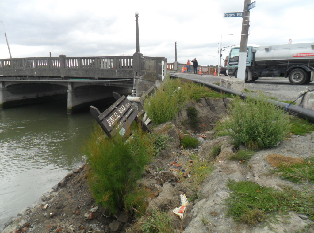
November 2021. I would trek Avon River's residential red-zone where ruined-houses were demolished leaving parkland both sides of Avon River. New Medway St Footbridge construction materials lay on both riverbanks. Two big cranes stood on riverbanks: a green-crane Avonside Dr side, a yellow-crane River Rd side. An Infomation-board River Rd side, hailed Medway St Footbridge's rebuild which would open in 2022. The Board also said bits of old stored bridge were used in various post-quake construction projects in the city.
Gayhurst Rd Bridge: Concrete, three span. Spans OK. The road-join was slumped Dallington Tce & Locksley Ave sides, exposing footpath- pipes & footpath-ends. Abutments were cracked Dallington Tce & Locksley Ave sides. Gayhurst Rd Bridge would be demolished & rebuilt. It reopened in August 2015.
A Dallington Tce road-sign:
TEMPORARY ROAD
CLOSURE
DALLINGTON TCE CLOSED
BETWEEN 16 DALLINGTON TCE
AND McBRATNEYS ROAD
7.00am TUESDAY 7/02/2012
TO 5.00pm FRIDAY 24/02/2012
24 HOURS FOR ENQUIRIES
PH...
There were many road-closure signs around Christchurch. We'd see many more during quake-years.
A power-pole sign:
R :)
ZONE
net.
2022. Gayhurst Rd / Locksley Ave: By rebuilt Gayhurst Rd Bridge, Dallington Landing would become a covered picnic-spot, opened on residential red-zone land where housing was demolished.


15.02.12. Gayhurst Rd Bridge, quake slumped road join, Gayhurst Rd / Dallington Tce. Gayhurst Rd Bridge would be demolished, rebuilt, reopened Aug 2015


15.02.12. Gayhurst Rd Bridge, quake cracked abutment, Gayhurst Rd / Dallington Tce. Gayhurst Rd Bridge would be demolished, rebuilt, reopened Aug 2015


15.02.12. Gayhurst Rd Bridge, quake slumped footpath by abutment, Gayhurst Rd / Avonside Dr. Gayhurst Rd Bridge would be demolished, rebuilt, reopened Aug 2015

15.02.12. Avonside Dr view, quake damaged Gayhurst Rd Bridge. It would be demolished, rebuilt, reopened Aug 2015

15.02.12. Avonside Dr view, quake cracked abutment, Gayhurst Rd Bridge, Gayhurst Rd / Locksley Ave. Gayhurst Rd Bridge would be demolished, rebuilt, reopened Aug 2015


15.02.12. Gayhurst Rd Bridge view, quake trashed, abandoned housing, Gayhurst Rd / Locksley Ave. The housing would be demolished. 2022. Dallington Landing, a picnic spot would be opened on red zoned, housing demolished land

15.02.12. Gayhurst Rd Bridge, quake cracked abutment, slumped road join, Gayhurst Rd / Locksley Ave. Gayhurst Rd Bridge would be demolished, rebuilt, reopened Aug 2015

Snell Pl Footbridge: Concrete, one arch span. The concrete-span was spalled downriver side of the concrete-arch apex. The concrete-abutment was cracked Avonside Dr side. The footbridge was steel-mesh-fence-cordon closed. An EXTREME DANGER KEEP OUT threat-sign. Snell Pl Footbridge would be demolished & rebuilt.

15.02.12. Locksley Ave view, quake slumped, concrete drain, Avon River bank, Avonside Dr. The drain would be demolished

15.02.12. Snell Pl Footbridge, quake trashed, closed, between Locksley Ave & Avonside Dr. Snell Pl Footbridge would be demolished

15.02.12. Snell Pl Footbridge, quake cracked abutment, Avonside Dr side

15.02.12. EXTREME DANGER KEEP OUT. Steel mesh fence cordon. Snell Pl Footbridge, quake trashed, closed, Locksley Ave side. Snell Pl Footbridge would be demolished

15.02.12. Snell Pl Footbridge, quake spalled, span arch apex, Locksley Ave side. Snell Pl Footbridge would be demolished

Locksley Ave, Kerrs Reach: Avon Rowing Club was gone, demolished on the opposite bank of Avon River. Avon Rowing Club would be rebuilt. Further on, while parked by red-zone ruined-houses, I watched an orange-dredger & two City Care workmen dredging weeds from Avon River.

15.02.12. Locksley Ave view, Avon Rowing Club, post quake, demolition site, Kerrs Reach, Avon River. Avon Rowing Club would be rebuilt

15.02.12. Orange, plastic, road cone cordon. Locksley Ave view, City Care, post quake, water weed dredging, Kerrs Reach, Avon River


15.02.12. Quake trashed, boarded house, Locksley Ave, Kerrs Reach
Avondale Rd Bridge: Concrete, three span. Spans OK. Abutments were skewed Avonside Dr side. There were road-cracks across the bridge at road- joins & patch-repairs with yellow, hardened foam & tarseal at cracks. 2013. The bridge would be repaired: abutments demolished & replaced. SCIRT took its time with repairs so the bridge would be closed for all of 2013. Never mind inconvenienced locals driving long detours. Similar obstacle-courses were made by SCIRT for years in post-quake Christchurch.

15.02.12. New Brighton Rd, upriver view, quake damaged, Avondale Rd Bridge

15.02.12. Avondale Rd Bridge, quake tilted abutment, spalled span end, New Brighton Rd, upriver side. The abutment would be demolished, replaced by SCIRT, 2013

15.02.12. Avondale Rd Bridge, quake tilted abutment & span end, Avondale Rd, downriver side. The abutment would be demolished, replaced by SCIRT, 2013

15.02.12. Avondale Rd Bridge, quake tilted abutment & light poles, Avondale Rd, downriver side. The abutment would be demolished, replaced by SCIRT, 2013


15.02.12. Avondale Rd Bridge, quake separated abutment, span & hand rail, Avondale Rd, downriver side. The abutment would be demolished, replaced by SCIRT, 2013

15.02.12. Avondale Rd Bridge, patch repairs to join between abutment & span, Avondale Rd side


15.02.12. Avondale Rd Bridge, quake tilted abutment & patch repairs between abutment & span, Avonside Dr, upriver side. The abutment would be demolished, replaced by SCIRT, 2013


15.02.12. Avondale Rd Bridge view, quake survivor housing, New Brighton Rd

15.02.12. Quake road damage between Avondale Rd Bridge, road deck & abutment, New Brighton Rd side


15.02.12. Avondale Rd Bridge, quake tilted abutment, span & hand rail, New Brighton Rd side. The abutment would be demolished, replaced by SCIRT, 2013

15.02.12. New Brighton Rd, downriver view, quake damaged, Avondale Rd Bridge

15.02.12. Green, plastic, sewage tank, New Brighton Rd / Avondale Rd Bridge traffic circle
Anzac Bridge: Concrete, three span. Spans OK. Big bridge, heavy traffic. Nearby New Brighton Rd & Anzac Dr: bumpy, due to the waterway between Travis Wetland & Avon River.

15.02.12. New Brighton Rd, upriver view, quake damaged, Anzac Bridge

15.02.12. Anzac Bridge NE cnr, quake flooded, cycle track, quake tilted abutment, spalled span


15.02.12.Anzac Bridge NE cnr, quake damaged abutment & plinth


15.02.12. Anzac Bridge, post quake, upriver view, Avon River

15.02.12. Anzac Bridge NW cnr, quake damaged abutment & pavement join

Concrete cycle-tracks below the bridge were trashed & flooded. Fish swam in flooded cracks on the south side. Cycle-track concrete-slabs were damaged with some 1m high tilted-separations New Brighton Rd side & Hulverston Dr side. There was spalled concrete at cycle-track edges Hulverston Dr side.

15.02.12. Road works, Hulverston Dr by Anzac Bridge

15.02.12. Anzac Bridge NW cnr, quake trashed / flooded cycle track


15.02.12. Anzac Bridge NW cnr, quake tilted abutment


15.02.12. Anzac Bridge NW cnr, car tyres below quake tilted abutment

Concrete-abutments were skewed at odd angles with masses of old rubber-tyres amongst abutment supports. Light=poles & light-plinths were skewed at bridge ends. Acute-angle gaps were between concrete-span ends & concrete-abutments.

15.02.12. Quake damaged New Brighton Rd nr Anzac Bridge. Concrete curb pulled apart from tarseal

15.02.12. Anzac Bridge SE cnr, quake cracked abutment


15.02.12. Anzac Bridge SE cnr, quake cracked, spalled bridge piers


15.02.12. Anzac Bridge SE cnr, quake trashed / flooded cycle track, quake tilted abutment


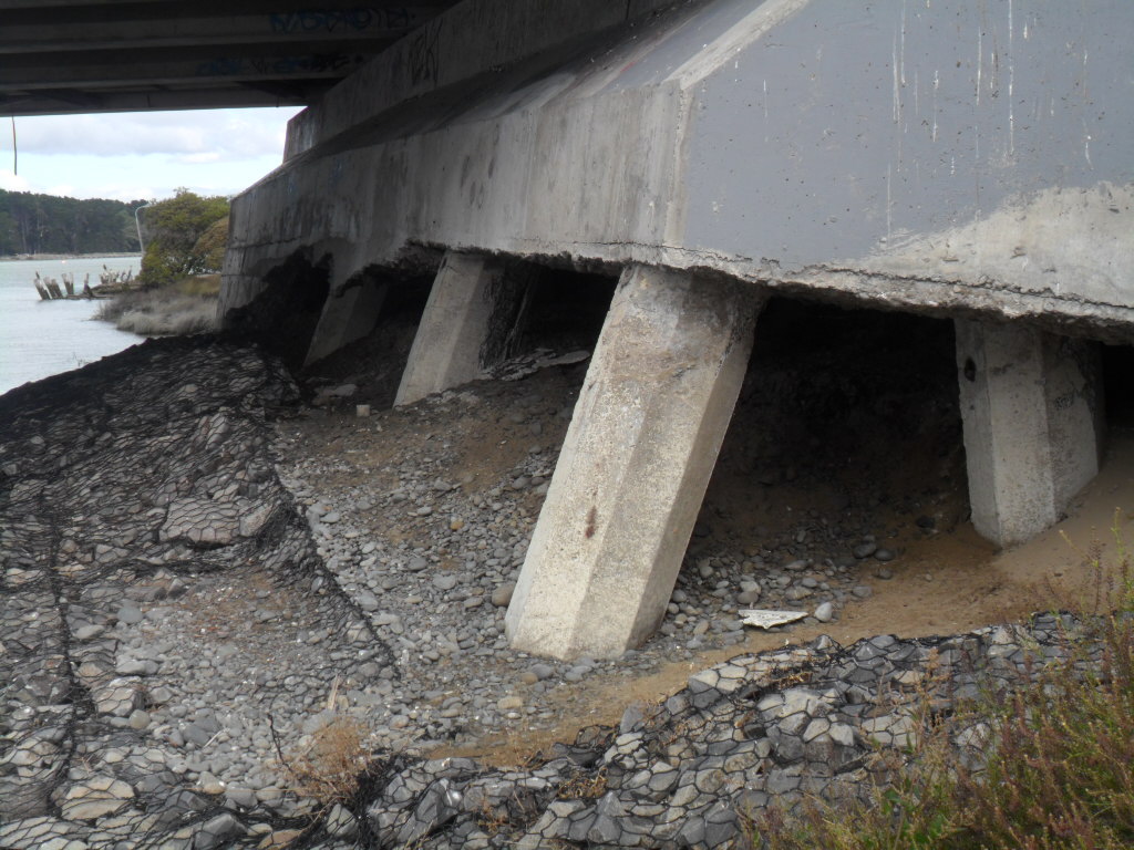
Of the eight square concrete-piers in the riverbed which supported the concrete-spans, two square concrete-piers had spalling & cracked- concrete below spans! There was superficial spalling at abutment edges.

15.02.12. Anzac Bridge SE cnr, quake trashed / flooded cycle track, quake tilted abutment


15.02.12. Downriver view, quake damaged, Anzac Bridge

15.02.12. Anzac Bridge SW cnr, quake tilted abutment


15.02.12. Anzac Bridge SW cnr, old tyres below quake tilted abutment

15.02.12. Anzac Bridge SW cnr, quake spalled, concrete wall by cycle track


15.02.12. Anzac Bridge SW cnr, quake cracked & spalled piers


15.02.12. Anzac Bridge SW cnr, quake trashed / flooded cycle track, quake tilted abutment


Wainoni Rd Bridge: Concrete, three span. Spans OK. There were concrete-slab separations at light-plinths & the concrete-barrier in middle of the bridge Wainoni Rd end. Downriver side, the cycle-track slumped at abutment-ends. The tarseal cycle-track was sunk a foot in places below the concrete cycle-track both bridge-ends, due to abutments-slumping. I crossed the bridge on the footpath by the cycle-track going over the bridge.

15.02.12. New Brighton Rd, upriver view, quake damaged, Wainoni Rd Bridge

15.02.12. Wainoni Rd Bridge, quake cracked light plinth, New Brighton Rd


15.02.12. Wainoni Rd Bridge, post quake patch between abutment & road deck, New Brighton Rd. Ski-jump effect after post quake road repair


15.02.12. Wainoni Rd Bridge, quake damaged, part repaired cycle track, New Brighton Rd. River bank slumped below cycle deck

15.02.12. Wainoni Rd Bridge, quake bent, cycle track span, downriver side. Steel, wing wall, quake skewed

15.02.12. Wainoni Rd Bridge, post quake, downriver view, Avon River

15.02.12. Wainoni Rd Bridge, post quake, cycle track, downriver side, Wainoni Rd

15.02.12. Wainoni Rd Bridge, quake slumped join between abutment & road deck, Wainoni Rd

15.02.12. Wainoni Rd Bridge, quake bent, cycle track above abutment, Wainoni Rd


15.02.12. Avon River stopbank, downriver view, quake damaged, Wainoni Rd Bridge, Wainoni Rd


15.02.12. Wainoni Rd Bridge, Wainoni Rd view, post quake, road patching on slumped abutment, aka ski-jump effect


15.02.12. Wainoni Rd Bridge, quake cracked, light plinth, Wainoni Rd


15.02.12. Upriver view, quake damaged, Wainoni Rd Bridge, Wainoni Rd

15.02.12. Quake trashed house nr Wainoni Rd Bridge, New Brighton Rd. The house would be demolished


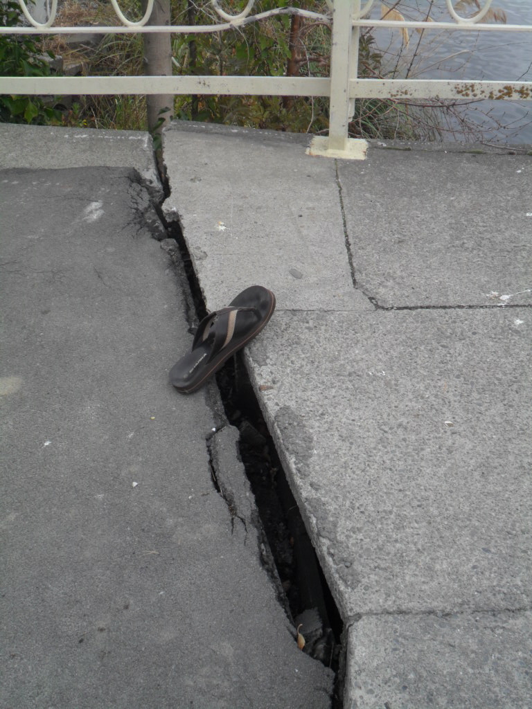
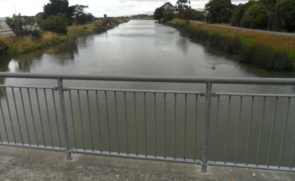
Pages Rd Bridge: Concrete, three span. Spans OK. There were tarseal-cracks across the bridge at road-joins both sides. There was superficial stonework-cracks at abutments Owles Tce side & Wairoa St side. There were deep cracks on the riverbank Owles Tce side due to lateral- spreading. Wairoa St side, there were cracks on the riverbank, but stopbank-shingle was repaired.

15.02.12. New Brighton Rd upriver view, quake damaged Pages Rd Bridge

15.02.12. FOOTPATH CLOSED. Pages Rd Bridge NE cnr, post quake road works


15.02.12. Road island view, quake damaged, Pages Rd Bridge, New Brighton side

15.02.12. Pages Rd Bridge SE cnr, quake damaged abutment, slumped Avon River bank, due to lateral spreading


15.02.12. Pages Rd Bridge, post quake, black plastic, sewage pipes


15.02.12. Pages Rd Bridge, downriver view, Avon River. Owles Tce left, raised stopbank, Wairoa St right

15.02.12. Pages Rd Bridge SE cnr, abutment & wing wall quake damage, Owles Tce side


15.02.12. Pages Rd Bridge SW cnr, abutment quake damage, Wairoa St side

15.02.12. Pages Rd Bridge SW cnr, abutment & road patch repairs, Wairoa St side, aka ski-jump effect


15.02.12. Pages Rd Bridge SW cnr, abutment quake damage, Wairoa St side, aka ski-jump effect


15.02.12. Wairoa St stopbank, downriver view, quake damaged Pages Rd Bridge

15.02.12. Orange, plastic, road cone cordon. Pages Rd Bridge NW cnr, post quake road works
South Brighton Bridge: Concrete, three span. Big bridge. Concrete-spans OK. Spans were supported by black-rubber-blocks between spans & piers & between span-ends & abutments. Quakes had horizontally-rotated the concrete-spans & road-deck clockwise, so that the northwest corner span-deck stuck out northwards from the bridge away from the abutment & the southeast corner span-deck stuck out southwards from the bridge away from the other abutment.

15.02.12. Avon River Estuary, South Brighton Bridge. Port Hills backdrop


15.02.12. Bridge St view, Avon - Heathcote Estuary. Mt Pleasant, Mt Cavendish, Port Hills backdrop

15.02.12. Bridge St, upriver view, Avon River Estuary, towards New Brighton
Post-quakes, as Bridge St was misaligned with South Brighton Bridge road-deck, when driving across one had to snake across at bridge-ends.

15.02.12. South Brighton Bridge NE cnr, quake broken, warped handrail, Bridge St, due to horizontal clockwise rotation of bridge spans. NE cnr rotated the width of a tyre tread


15.02.12. South Brighton Bridge NE cnr view, SE cnr & quake shifted span & road deck, Bridge St

15.02.12. South Brighton Bridge NE cnr, quake split handrail & southwards shift of span & road deck, Bridge St, due to clockwise rotation of span & road deck. Sticking out bit is the non-rotated, abutment top


15.02.12. South Brighton Bridge NE cnr, quake tilted abutment, shifted span, Bridge St


15.02.12. South Brighton Bridge NE cnr, upriver view, quake shifted spans, Bridge St
Was the black-rubber-block crushed from under the span-end at the southeast corner-join between span-end & abutment? It was plugged with two wooden-planks! What were engineers / bridge-repairers thinking?

15.02.12. South Brighton Bridge, NW cnr view, quake split & warped handrail & northwards shift of span & road deck, Bridge St, due to clockwise rotation of span & road deck


15.02.12. South Brighton Bridge NW cnr, upriver view, quake shifted spans, Bridge St


15.02.12. South Brighton Bridge NW cnr, quake split handrail & northwards shift of span & road deck, by quake cracked abutment, Bridge St


15.02.12. South Brighton Bridge NW cnr, quake shifted span & road deck, exposed abutment supports, Bridge St


Concrete-span & road-deck at the northwest end of the bridge had clockwise rotated the most, about two feet northwards & diagonally opposite the southeast span & road-deck had clockwise rotated about one foot southwards in the estuary-mouth direction. Clockwise rotation direction was easily seen at road-joins above.

15.02.12. South Brighton Bridge SW cnr view, NW cnr & northwards shift of span & road deck, Bridge St

15.02.12. South Brighton Bridge SW cnr, post quake, black, sewage pipe, quake split handrail, Bridge St, showing clockwise rotation of road deck away from abutment, hand rail


15.02.12. South Brighton Bridge SW cnr, mangled rubber lining between span, road deck & abutment & northwards, quake shifted span & road deck, Bridge St. Sticking out bit is the non-rotated abutment


15.02.12. South Brighton Bridge SW cnr, downriver view, quake tilted abutment, quake shifted span & road deck, Bridge St


15.02.12. South Brighton Bridge SW cnr, quake displaced black, rubber block, below span, plugged by wooden planks, by quake tilted abutment, Bridge St


15.02.12. South Brighton Bridge SW cnr, downriver view, quake shifted bridge spans, Bridge St
Abutments at both bridge-ends were skewed, acute angles between span-ends & abutment-joins. The black-rubber-block was displaced from the join between abutment & span-end at the southwest corner of the bridge. Plugged with two wooden-planks again!

15.02.12. South Brighton Bridge SE cnr, quake moved span & deck southwards away from abutment, Bridge St, due to clockwise rotation of spans


15.02.12. South Brighton Bridge SE cnr, quake split, warped handrail, post quake, black, sewage pipe, southwards movement of span & road deck, Bridge St, due to clockwise rotation of spans


15.02.12. South Brighton Bridge SE cnr, quake moved span & road deck, Bridge St


15.02.12. South Brighton Bridge SE cnr, quake moved span & road deck, angled away from abutment, black, rubber block gone, Bridge St


15.02.12. South Brighton Bridge SE cnr, quake moved span & road deck, above abutment supports, Bridge St


15.02.12. South Brighton Bridge SE cnr, upriver view, quake shifted spans, Bridge St


Steel-handrails at the four corners of the bridge were split & warped by bridge-movement. Rubber-linings between abutments & road-joins were twisted & mangled at the road-surface.

15.02.12. South Brighton Bridge NE cnr, quake split hand rail, Bridge St

15.02.12. South Brighton Bridge, quake split handrail, centre of upriver span deck, Bridge St

15.02.12. South Brighton Bridge NW cnr, upriver span deck, quake moved northwards, Bridge St, due to clockwise rotation of spans

15.02.12. South Brighton Bridge SW cnr, quake split handrail, post quake, black, sewage pipe, Bridge St

15.02.12. South Brighton Bridge SE cnr, quake split, handrail, post quake, black, sewage pipe, span deck, quake moved southwards, downriver, Bridge St, due to clockwise rotation of span & road deck

15.02.12. South Brighton Bridge SE cnr, clockwise moved span deck & road southwards, Bridge St


15.02.12. South Brighton Bridge SE cnr, quake split, warped handrail, post quake, black, sewage pipe, clockwise rotated span & road deck, southwards, Bridge St

A lovely southern view: Avon River Estuary & Port Hills. But Pleasant Point Yacht Club was gone, demolished.

15.02.12. South Brighton Bridge view, Avon - Heathcote Estuary, Pleasant Point Yacht Club demolition site. Port Hills backdrop


Although South Brighton Bridge looked reasonably OK after 10 000 quakes & patch-repairs, with all the twisting, tilting & shifting of bridge-structures, the steel-reinforcements were stressed!
As the Alpine Fault 100km away hadn't ruptured for decades, seismologists said it would shake Canterbury for two minutes, longer than any Christchurch quakes over the past 17 months.
Over the past couple of weeks I'd looked at 14 Avon River bridges, from Manchester St Bridge in the CBD red-zone & downriver to South Brighton Bridge over Avon Estuary. All were damaged. Why were engineers & Council allowing damaged bridges to be used still with just patch-repairs? Reminiscent of patch-repairs done to buildings before the 22 February 2011 Quake! Never mind disaster access & egress for eastern suburb residents. Nor tsunami danger if an offshore fault ruptured.
Thursday 16.02.12. 4.13am, M4.1 quake, 5km depth, 10km east of Christchurch (GeoNet). I slept through it.
Thursday 23.02.12. I snaked across South Brighton Bridge again. The south-side lane was orange-plastic-road-cone-cordoned, making the bridge one lane only with temporary traffic-lights at each end of the bridge. A year post 22 February 2011 Quake, it was time Council engineers jacked-up the bridge spans! That evening near St Bedes College one of my Honda Civic's new tyres had a blowout. My first blowout in nearly 17 years living in Christchurch!
While I viewed Avon River bridges, it was an interregnum between Council & CERA forming SCIRT, which would take years to repair ruined- infrastructure, ruined-roads & ruined-bridges. Christchurch would become Cone City with road-repairs, bridge-repairs, detours & rebuilds.
*Trekked Stanmore Rd, Swanns Rd, Medway St, Gayhurst Rd, Snell Pl, Locksley Ave, Avondale Rd, Anzac Dr, Wainoni Rd, Pages Rd, Bridge St. 265 images.
Coda:
Christchurch Mail, 16.08.12, reported Avon River bridge repairs by SCIRT:
South Brighton Bridge would be repaired - taking about three years to repair by April 2015.
Pages Rd Bridge: "Repairs will begin when Bridge St Bridge [sic] is completed."
Avondale Rd Bridge: "Work has recently started."
Gayhurst Rd Bridge: "Early next year."
Anzac Bridge. "Mid 2013."
Meanwhile citizens had to use dangerous bridges for years!
Content & pics Copyright Mark JS Esslemont.
See Chch's crucial Dallington bridge ready for business (The Press / Stuff Co).
No comments:
Post a Comment