
12.09.12. Orange, plastic bollard cordon. Steel mesh fence cordon. CCDU's Blueprint, E / S Frame nexus: St Asaph St, High St, Madras St

But CCDU's shrunken, core CBD ignored many working businesses outside its core CBD. All that the L shaped Green Frame did was Frame some of the old CBD with planned vegetation on demolition sites, sprinkled with old CBD bldgs. Later new apartment blocks would border the E Frame / Rauora Park near Latimer Sq & vegetated laneways would revamp the S Frame between parallel St Asaph St & Tuam St.
*Asterisk shows CCDU's Blueprint Frame land:

*12.09.12. Red zone, steel mesh fence cordoned, quake damaged bldgs, St Asaph St, S Frame. The area would become Salt District

*12.09.12. Red zone, steel mesh fence cordoned, demolition sites, St Asaph St, S Frame. The area would become Salt District


*12.09.12. Shipping containers, steel mesh fence cordon. McKenzie Willis demolition site, red zone, St Asaph St, S Frame. The area would become Salt District

N border of CERA's core CBD was meandering Avon River, which caused huge, liquefaction damage during 2010-2011 quakes. CCDU wanted to rebuild Christchurch CBD on old swampland, atop Christchurch Fault which damaged the CBD in the 2010 Boxing Day Quake. Christchurch Fault was parallel to lethal Port Hills Fault which caused great damage in 22.02.11 Killer Quake.
All that CCDU did with its Blueprint Frame was encourage taggers & their graffiti on quake-sound, CCDU condemned bldgs. Never mind tagging in damaged E suburbs. Despite CERA occupying its red zone CBD, taggers had already scribbled on walls & windows in the S Frame near the temporary bus exchange.

*12.09.12. Quake survivor, Buddle Findlay lawyers office, St Asaph St, S Frame


12.09.12. Post quakes, EPIC Innovation Precinct, St Asaph St / Manchester St, S Frame


E Frame was between Madras St & Manchester St, bordered by Avon River in the N & Lichfield St / St Asaph St in the S. (The latter 2 streets forming the Frame L cnr with Madras St. Later on Lichfield St would be the border between E Frame & S Frame). As CERA had opened bits of red zone Tuam St last week, I wanted to see S Frame between St Asaph St & Tuam St, from St Asaph St / High St / Madras St, westbound to Montreal St, Health Precinct, near Hagley Park.

*12.09.12. Quake survivor, the drawing room, St Asaph St / Manchester St, S Frame

*12.09.12. St Asaph St view, roofless Odeon Theatre, part demolished, S Frame

*28.01.13. Part demolished, Odeon Theatre auditorium, S Frame, St Asaph St. Odeon Theatre stood part demolished since Sept 2012. So much for CERA's asbestos hazard prevention.

12.09.12. White / orange, plastic bollard cordon. St Asaph view, S Frame to Tuam St, old Council bldg, awaited demolition for the Bus Interchange


*12.09.12. Orange / white, plastic bollard cordon. Quake survivor, Team Hutchison Ford, St Asaph St, S Frame

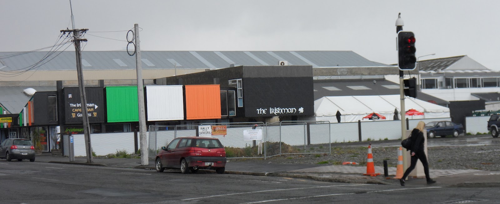
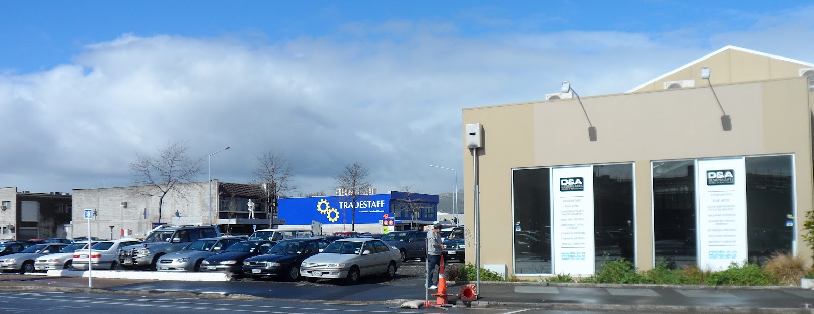
*12.09.12. Quake survivor, Tradestaff, St Asaph St / Colombo St, S Frame
Wed 12.09.12. Cold, wet morning, snow sprinkled Port Hills & Mt Herbert. 18 months post 22.02.11 Killer Quake, it was impossible to see the E Frame, as Manchester St was still within CERA's banned CBD red zone, steel mesh fence cordoned, so I started my S Frame trek at Madras St / High St / St Asaph St nexus.

*12.09.12. St Asaph St / Colombo St, NW view, S Frame demolition sites to Tuam St, the area where 16 people died in the 22.02.11 quake


*12.09.12. S Frame, quake survivor businesses, St Asaph St


Snapped pics of perfectly good, commercial bldgs in the S Frame, like McHargs, Terrell Motor Group, Jansen, Peugeot, Subaru, Alfa Romeo / Fiat, Citroen, Great Wall, Spraystore, Flexilease, Toyota, Kent Distributors, codeblue, mostly car dealers, like Jaguar, Archibalds, Volvo, VW, Miles Continental, Lexus, paul kelly... There were also many viable businesses, S of the S Frame, extending to Moorhouse Ave & beyond.

*12.09.12. S Frame, quake survivor businesses, St Asaph St


*12.09.12. S Frame, quake survivor, Health Precinct, St Asaph St / Antigua St

*12.09.12. E view, St Asaph St, S Frame left

12.09.12. Steel mesh fence cordon. Post quake, Central Police, temp site, St Asaph St / Antigua St, as quake damaged, Hereford St, Central Police bldg awaited implosion, 31.05.15


12.09.12. Steel mesh fence cordon. Canterbury Brewery, awaiting demolition, St Asaph St / Antigua St. The area would become CCDU's Blueprint Metro Sports Facility

Many viable businesses in the S Frame, bordered by Tuam St, St Asaph St, Madras St, Montreal St. After quake destruction & CERA demolitions, CCDU buying viable businesses in the Frame, at market value, then demolishing those sites for vegetation replacement was mad! Where did CERA's Isaacs & minions think those viable businesses would go? CCDU would quietly drop that mad plan, most of the above-mentioned, S Frame businesses would survive the quakes.

*12.09.12. S Frame / Health Precinct, quake survivor, hospital carpark, Antigua St / St Asaph St


*12.09.12. S Frame, quake survivor Jaguar, Antigua St

Isaacs's CCDU Blueprint incl expensive projects like a 35 000 seater Stadium, Convention Centre / Te Pae, Maori Cultural Centre, Hagley Park Cricket Oval, Metro Sports Facility... The Blueprint required massive demolitions & "taking" of privately owned CBD land for NZ National govt's / CERA's disaster capitalism. Example: NZ National govt's / CERA's Blueprint Justice & Emergency Services precinct, incl Ministry of Justice law courts, Corrections, Cops, St John ambulances, Fire Service, Ministry of Civil Defence & Emergency Management, all in one CBD block between Lichfield St & Tuam St. Terrorists could laugh all the way to their internet manifestos & bombs at such a juicy target. PM Key, CERA minister Brownlee, CERA minions Sutton & Isaacs, hadn't a clue.

*12.09.12. S Frame, quake survivor business, Tuam St


There was enough quake demolition wasteland in the CBD & the Frame for parkland, without destroying good businesses & bldgs for a rigid Frame. CERA's wanted to inflate core CBD land prices within the Frame, with Frame land later resold by CERA for profit. So much for market regulation of land prices.

*12.09.12. S Frame, quake survivor business, Tuam St


For years, vegetation would extend all along Avon River banks from the CBD to Avon River mouth in riverside suburbs destroyed by quakes & CERA's residential red zoning & demolitions. Avon River Park was already mooted by an 18 500 signature petition sent to parliament. So far, NZ National govt was quiet about what to do with all the residential red zone land it land-grabbed along Avon River banks.
2020. NZ Labour coalition govt would start returning residential red zone / Crown land to Christchurch Council.

*12.09.12. S Frame, quake survivor, Office Max, Tuam St / Durham St South


*12.09.12. S Frame, quake survivor business, Tuam St


12.09.12. Post quake, temp, Central Library Tuam, next to post quake, temp, bus exchange, Tuam St. It & other bldgs would be demolished for NZ National govt's / CERA's Blueprint Justice & Emergency Services precinct

*12.09.12. S Frame, quake survivor business, Tuam St


12.09.12. Tuam St, temp, bus exchange, carpark NE view, red zone high rise demolitions: Hotel Grand Chancellor left, Westpac middle, Holiday Inn right

*12.09.12. S Frame, quake survivor businesses, Tuam St SE view, Colombo St to St Asaph St

*12.09.12. Tuam St view, S Frame, demolition site carpark, S to St Asaph St

12.09.12. Colombo St, E view, CBD red zone bldgs awaiting demolition: Holiday Inn left, Tuam St, old Council bldg right. Old Council bldg would be demolished for the new Bus Interchange

12.09.12. Post quake, CBD direction sign, Colombo St / Tuam St


*12.09.12. Tuam St / Colombo St view, S Frame, left & right of Colombo St. Port Hills backdrop


*12.09.12. S Frame, demolition site carpark, Tuam St / Colombo St

*12.09.12. S Frame, quake survivor businesses, Tuam St

12.09.12. Quake damaged, old, Council bldg, Tuam St, awaiting demolition for the Bus Interchange


12.09.12. Steel mesh fence cordon. Red zone bldg backing Sol Sq, Tuam St


*12.09.12. S Frame, quake survivor Ford, Tuam St


*12.09.12. Steel mesh fence cordon. S Frame, quake survivor business, Tuam St


*12.09.12. Steel mesh fence cordon. S Frame, quake survivor, old Council bldg, Tuam St. Stacked shipping containers prop Odeon Theatre facade next door

There was much quake & demolition carnage in the E part of the S Frame, but less damage & demolitions in the W part of the S Frame, W of Colombo St, where 16 people died in the 22.02.11 Killer Quake, due to old, unreinforced, brick bldgs collapsing on Colombo St.

*12.09.12. Steel mesh fence cordon. S Frame, Real Groovy, Odeon Theatre, propped by stacked shipping containers, Tuam St / Manchester St. Real Groovy would be demolished


12.09.12. Steel mesh fence cordon. Tuam St view, post quake, EPIC Innovation Precinct, Manchester St. Real Groovy right would be demolished

12.09.12. Steel mesh fence cordon. Red zone, demolition site, Tuam St / Manchester St

12.09.12. Steel mesh fence cordon. Tuam St view, stacked shipping containers propping bldg facade, red zone, Manchester St

12.09.12. Tuam St / Manchester St, N view, red zone, demolition sites, ghost bldgs. Te Wananga o Aotearoa bldg mid left would be refurbished as The Muse Art Hotel. Majestic Theatre right would be demolished for CERA's Blueprint E Frame

*12.09.12. Steel mesh fence cordon. S Frame, Real Groovy, Odeon Theatre, propped by stacked shipping containers, Tuam St / Manchester St. Real Groovy would be demolished

*12.09.12. NO ENTRY. Steel mesh fence cordons. Tuam St / Manchester St, W view, S Frame left, CBD red zone right

12.09.12. Welcome to Christchurch sign, CBD red zone, steel mesh fence cordon, Manchester St / Tuam St

12.09.12. Steel mesh fence cordon. Tuam St / Manchester St, NW view, CBD red zone, ghost bldgs. Holiday Inn awaited demolition middle. Te Wananga o Aotearoa right awaited refurbishing as The Muse Art Hotel


*12.09.12. Steel mesh fence cordons. Tuam St / Manchester St, S view, post quake, EPIC Innovation Precinct left, Odeon Theatre salvaged roof right, S Frame


*12.09.12. Steel mesh fence cordons. Tuam St / Manchester St, E view, S Frame right

*12.09.12. Steel mesh fence cordon. Tuam St / Manchester St, E view, Alice in Videoland left, part demolished, McKenzie Willis, steel propped right, S Frame. McKenzie Willis facade would be restored for a new shops / offices bldg, part of the Salt District

*12.09.12. S Frame, part demolished, Mckenzie Willis, steel propped, Tuam St. McKenzie Willis facade would be restored for a new shops / offices bldg, part of the Salt District


Using its Blueprint, CERA wanted to jackboot car dealers & other private businesses from the S Frame, so that the Health Precinct could expand into the S Frame, at the expense of car dealers & other private businesses in the S Frame. Meanwhile the temp Central Police bldg would inhabit a demo site opp the S Frame, St Asaph St / Antigua St, until CERA's Blueprint Justice & Emergency Services bldg was built between Lichfield St & Tuam St. Behind a steel mesh fence cordon, a threat sign:
THIS SITE IS REGULARLY
MONITORED
AND PATROLLED
BY NZ POLICE

*12.09.12. Steel mesh fence cordon. S Frame, High St view, part demolished, steel propped, McKenzie Willis. McKenzie Willis facade would be restored for a new shops / offices bldg, part of Salt District

*12.09.12. Steel mesh fence cordon. High St, NE view, red zone, S Frame, demolition sites towards Lichfield St

12.09.12. Quake survivor, CI business (old Post Office bldg) High St / Tuam St

12.09.12. ROAD CLOSED. Steel mesh fence cordon. Tuam St / High St view, red zone High St. Holiday Inn & Majestic Theatre right awaited demolition


*12.09.12. Stacked shipping container cordon. Steel mesh fence cordon. High St view, red zone, S Frame, demolition site towards Lichfield St. Majestic Theatre would be demolished for CERA's Blueprint E Frame

*12.09.12. Steel mesh fence cordon. High St view, red zone, demolition sites to ghost bldgs & abandoned IR bldg in E Frame. IR bldg would survive the quakes

*12.09.12. Steel mesh fence cordon. Abandoned CF Cotter & Co, red zone, High St, S Frame


*12.09.12. Abandoned CF Cotter & Co, High St, surrounded by red zone, S Frame, demolition sites & views to ghost bldgs - Lichfield St left, Poplar St right

*12.09.12. Abandoned, CF Cotter & Co, High St, backdropped by Poplar St, red zone, S Frame, demolition wasteland


*12.09.12. High St view of S Frame, demolition wasteland, Poplar St. Pink, plastic bucket on Poplar Mews demolition site. The quake survivor bldgs would become Dux Central


*12.09.12. High St view, S Frame, demolition wasteland by Ash St & Poplar St. Madras St, NG boutique right beyond on CCDU's Blueprint, 35 000 seater, roofed stadium site. 2022. NG Bldg would be demolished for the stadium

*12.09.12. High St view of S Frame demolition sites by Polar St & view across Madras St to Turners & Growers site, CCDU's Blueprint stadium site. NG boutique left awaited purchase by CERA for the stadium site. 2022. NG Bldg would be demolished

*12.09.12. S Frame, part demolished, steel propped, McKenzie Willis, Tuam St / High St. McKenzie Willis facade would be restored for a new shops / offices bldg, part of Salt District


*12.09.12. High St view of CPIT Fashion School left & part demolished, steel propped, McKenzie Willis in S Frame right. McKenzie Willis facade would be restored for a new shops / office bldg, part of Salt District


*12.09.12. High St / Tuam St, W view, S Frame left, Alice in Videoland (old Post Office bldg) right
I didn't snap all survivor bldgs in the S Frame, like Beggs Music Centre, Colombo St, nor Mollett St bldgs, but I saw enough to know that if CERA demolished all bldgs in the S Frame, Canterbury was ruled by megalomaniacs, CERA bosses overseeing destruction rather than recovery.
CERA would change tune, not buying all survivor bldgs for its Blueprint, citing "surplus to requirements." Meanwhile, survivor businesses in CERA's Blueprint Frame were messed around by CERA's Blueprint farce. Years after CERA was gone, CERA's Blueprint legacy, E Frame, demolition wasteland (Rauora Park) & dearth of replacement businesses & housing would cause post quake, Christchurch CBD to evolve extremely slowly. Successive NZ govts, Councils & ratepayers would have to clean up & sort out NZ National govt's / CERA's mess.
St Asaph St / Manchester St: If EPIC's (Enterprise Precinct & Innovation Campus) ugly, black shed, heralded CCDU's idea of modern bldgs, then CERA's rebuilt of Christchurch CBD would be extremely ugly.
Tuam St / Madras St, N view: Forbidden CBD red zone, E Frame, demolition wasteland & ghosts between Madras St & Manchester St. CCDU's Blueprint proposed buying the lot & making it parkland (later named Rauora Park).
Poplar St & Ash St: Pre quakes, boutiques gone, Poplar Mews gone, pubs gone, restaurants gone, businesses gone. All that was left of Poplar Mews, where Jake once flatted, was a pink, plastic bucket on demo mud. Only 2 abandoned restaurant bldgs left & demo wasteland in CERA's utopia. The abandoned bldgs would become Dux Central. Vodafone multi-storey & Vanguard Sq would be built on the demo wasteland, Poplar St / Tuam St.
Christ Church Cathedral saga continued, Anderton's court case blocking demolition of Christ Church Cathedral ghost.

*12.09.12. Tuam St view, S Frame ghost bldgs beyond Poplar St & Ash St demolition wasteland. Vodafone bldg & Vanguard Sq would be built right front. Abandoned bldgs right would become Dux Central


*12.09.12. S Frame, Poplar St / Ash St, demolition sites & ghost bldgs. Poplar Mews demolition site left. Start of S Frame, Lichfield St beyond, in gap between abandoned bldgs. White bldg right would become Dux Central. Other bldgs in the pic would be demolished


*12.09.12. Tuam St view, S Frame demolition sites, ghost bldgs. Poplar St left, Ash St ahead. Abandoned IR bldg behind right would survive the quakes


12.09.12. Post quakes, Tuam St / Madras St

*Trekked St Asaph St, Antigua St, Tuam St, High St. 173 images.
Thursday 13.09.12. CERA minister Brownlee's recent rant about "carping and moaning" green-zone, TC3 residential property owners "buggarizing around on Facebook all day," then Brownlee's apology, a diversion for the next NZ National govt / CERA attacks:
1. More red zoning in the Port Hills: 37 properties red zoned in Horotane Valley & Bridle Path Rd, Heathcote Valley. CERA's excuse: rockfall hazard. 443 Port Hills homes red zoned so far. Hillsborough homes, Lucas Ln were still white zoned, in limbo, awaiting CERA's intervention in October.
2. CERA announced that uninsured residential properties & vacant lots would be NZ National govt offered half Rateable Value, another National govt land-grab, the half land value offer stank, as vacant lots were uninsurable in NZ. National govt's conflating half price, vacant lots with half price, uninsured homes ripped off vacant lot owners. Commercial / industrial properties would get a similar NZ National govt offer to NZ National govt's residential red zone offer: recent RV plus half land value. CERA made the artificial red zones, then made ripoff offers.
3. Grand announcement by the Ministry of Education (MoE) Brownlee & education minister Hekia Parata presiding, that many Canterbury / Christchurch schools would close, merge, or relocate. Some daft suggestions by the MoE: Merger of Christchurch BH (1 300 boys) & Shirley BH (1 300 boys); Merger of Avonside GH & Christchurch GH... MoE's excuse for all the schools' disruption was quakes.
MoE wanted to close 13 schools & merge 18 schools. Parata's contention that some schools due for closure were less than 50 roll, stretched her generalization a bit, as due for closure Richmond School, Kendal School & Burnside Primary all had rolls greater than 50.
If Brownlee checked his Ilam constituency he'd know there was traffic congestion twice a day outside Burnside HS (roll 2 000+) when parents dropped off & fetched kids. And what did Parata & Co do? Propose a massively merged, cluster school, to cause more traffic jams in the E, in Aranui, on damaged roads. Never mind traffic jams caused by more merger proposals. (In future, that congested school would prove to be an educational cock-up, team teaching in barn like classrooms, scores of noisy kids milling around).
Leah was already affected by looming closure of McKenzie Residential School, Yaldhurst Rd, where she did part-time teaching of disruptive boys. Richmond School, Pavitt St, near Leah's private London St school, would close due to low roll.
While Canterbury citizens reeled from ongoing quakes, NZ National govt jackbooted Canterbury education, changing education facilities & communities. Never mind staffs', students', parents' traumas.
Why were there no changes to Invercargill's, Dunedin's, Wellington's, Auckland's education facilities? So much for Canterbury democracy.
Halswell School would be rebuilt. Leah taught there during our Oaklands sojourn.
Burnside Primary & Kendal School in Brownlee's Ilam constituency were slated for closure. Closure of Ilam primary schools was dumb, as many kids lived in Ilam. Burnside Primary & Kendal School, both fed Burnside HS (no closure). Both primary schools were about ten minutes walk from our home & about 10 minutes walk from Burnside HS.
Nearby Aorangi Primary was closed & demolished years ago (just a concrete slab & green playground left, locked gates). Closure of Burnside Primary & Kendal School was dumb, as Ilam kids would have no local school to go to.
Burnside survived quakes well & was a sought after school zone, pre & post quakes. As Burnside was an upmarket suburb, Kendal School & Burnside Primary asset sales could make mega bucks for NZ National govt. The closure / merger proposals of so many Christchurch schools was NZ National govt's disaster capitalism, selling taxpayer assets for profit.
Quake trashed, E suburb dwellers had 4 options: Leave town; stay on their damaged land in their damaged houses; move to "safe" suburbs like Burnside; move to city fringe developments, like at Halswell Junction Rd & send kids to Halswell School. Never mind there was no HS for some distance from Halswell.
Once a week, our sons had bussed from Oaklands School to Branston Intermediate for technology subjects. Leah bussed with kids once a week to Phillipstown School for technology subjects. Luke became a carpenter / joiner / salvager after leaving Burnside HS. The foundation for his career began at Branston Intermediate. Although Hornby was growing post quakes, MoE wanted to close Branston Intermediate & merge / relocate Phillipstown School with Woolston School.
MoE experimented on Canterbury with new cluster schools, like Lincoln / Rolleston cluster & clustering several Aranui & Avondale schools into a monster Aranui school, year 1 to year 13.
Whatever MoE's rationale for closures, mergers, relocations, boasting about sinking $1 billion into Canterbury education in the next decade was cynical cost saving. MoE's web page gobbledegook, "Shaping Education - Future Direction..." using the quakes as excuse for cost savings was disingenuous, as parents no longer had choice of decent, local schools.
After our arrival in Christchurch, mid 1995, we stayed in Sumner till the end of the year, but moved to Halswell, as we were dissatisfied with Jake's primary school education. The Sumner pre-school Luke went to was OK.
Our sons were primary educated at Oaklands School near Halswell, but 9 years ago we moved to Burnside, as we were dissatisfied with Jake's year 13 schooling at Hillmorton HS, where senior teachers & school management were negligent in their duty of care in several of Jake's year 13 subjects. (Too busy striking to sort out Jake's final year, school work). We wanted professional schooling for Luke at Burnside HS.
Afternoon, 22.02.11 Killer Quake, I stood with Leah in her London St school driveway, with other teachers & kids, while grey quakemire oozed from the ground, still aftershock jolting, while we smelt the malodour of collapsed & burning CTV. Shattered houses, businesses, Richmond Working Mens Club trembled around us. Quakemire oozed in streets. Fitzgerald Ave, northbound bridge by Avon Loop, collapsed.
High school teachers were at a strike meeting, HS pupils let loose in quake city, while primary school teachers stayed at their posts, long after the first quake strike, ensuring kids got home safely. Leah's school director battled ravaged roads to safely deliver a child to New Brighton then returned to her quaking school. Primary school teachers' bravery during quakes was never acknowledged by Parata.
Coda:
MoE would back off closing Burnside Primary, but would close Kendal School. Branston Intermediate & Phillipstown School would be closed. So much for nurturing NZ technology. Those closed schools were worth a fortune, as they were all in busy suburbs.
03.03.14. NZ National govt's, MoE's media release would announce the construction of a new primary school & new high school at rapidly growing Rolleston, S of Christchurch.
16.01.15. The Press reported that NZ National govt / CCDU would shrink the size of the Blueprint S Frame. CCDU's idea of buying survivor bldgs, like successful car dealerships in the Blueprint S Frame for parkland was dumb.
Feb 2016. Ongoing MoE negotiations with Christchurch Council for rebuilds of Avonside GH & Shirley BH on liquefactioned, QE11 demolition sites. Rebuilding liquefactioned schools on more liquefactioned land! MoE & Council hadn't learnt a thing from quakes.
Mon 23.01.23. While leah did her last teacher training at Seabrook McKenzie Centre, London St, I trekked S Frame lanes made between parallel Tuam St & St Asaph St. I started E side from Manchester St & ended up by W side Health Precinct, near Montreal St. Crossing busy Colombo St & Durham St S en route, the laneway rejoiced in the name, The Greenway / Te Ara Pu Ha. The Greenway consisted of ugly, grey concrete paving, embedded by intermittent slivers of pounamu greenstone, with grey gravelled, planter beds, native plantings & weeds, both sides of the grey concrete paving. There were intermittent grey concrete benches or wooden benches both sides of The Greenway, with a couple of grey concrete paved "Squares" en route. As most of The Greenway was constructed behind St Asaph St car dealers, what made my trek excruciatingly horrible were all the metallic bangings, crashings, clankings, buzzings from workshop machinery en route. Never mind millions of dollars spent on The Greenway!
Content & pics Copyright Mark JS Esslemont.
See Compensation offer slammed by owners (The Press / Stuff Co).
See Further red zone properties addressed (CERA).
See Port Hills rock roll zoning complete (CERA).
See Schools must adjust to changing region (The Press / Stuff Co).
See Land prices shrink Christchurch's south frame (The Press / Stuff Co).
See Avonside Girls Shirley Boys to be built at QE11 (The Press / Stuff Co).
No comments:
Post a Comment