No matter how much silt-clearing was done by manual digging or mechanical diggers, there was still dry silt on roads. Although roads & footpaths I trekked were cleared of grey-quakemire, they were grey with liquefaction-dust, like dry, gritty cement poured on roads. Never mind the ongoing Xmas Quake Swarm which began on 23.12.11. I developed a skin infection, after 16 months of trekking liquefactioned-roads. 1987 was the last time I had such an infection when I worked in QwaQwa during apartheid: long-drops, dusty, muddy, shitty streets, similar to post-quake Christchurch.
Monday 16.01.12. I wanted to see Burwood damages, west side of Anzac Dr, between Travis Rd by Travis Wetland in the north, New Brighton Rd by Avon River in the south. The developed swampland was almost surrounded by waterways, Avon River & swamp. Wetlands were on both sides of lumpy, patch-repaired Anzac Dr to Anzac Dr Bridge: an eastern creek, a western swamp. Both waterways had new houses close by. Why did Council allow housing development on swampland?
I circular-trekked along cleaned liquefactioned-roads, with a couple of detours snapping swampland ruined-housing & liquefaction-damages.
CERA Landcheck website, land status:
Brooker Ave: 72 properties, 69 red-zone, 3 green-zone.
Norcross St: 4 properties, all red-zone.
Corserland St: 38 properties, all red-zone.
Longview Pl: 20 properties, all red-zone.
Kingsbridge Dr: 67 properties, 36 red-zone, 31 green-zone.
Kingsbridge West: 39 properties (no housing), all green-zone.
Schumacher Pl: 8 properties, 3 red zone, 5 green-zone.
Rebecca Ave: 33 properties, all red-zone.
Red-zone land / housing was deemed by NZ National government / CERA to be too expensive to fix & people had to leave. Green-zone land / housing was deemed fixable & liveable. But no one moderated slow Tonkin & Taylor engineers who investigated & reported on quake-damaged land.
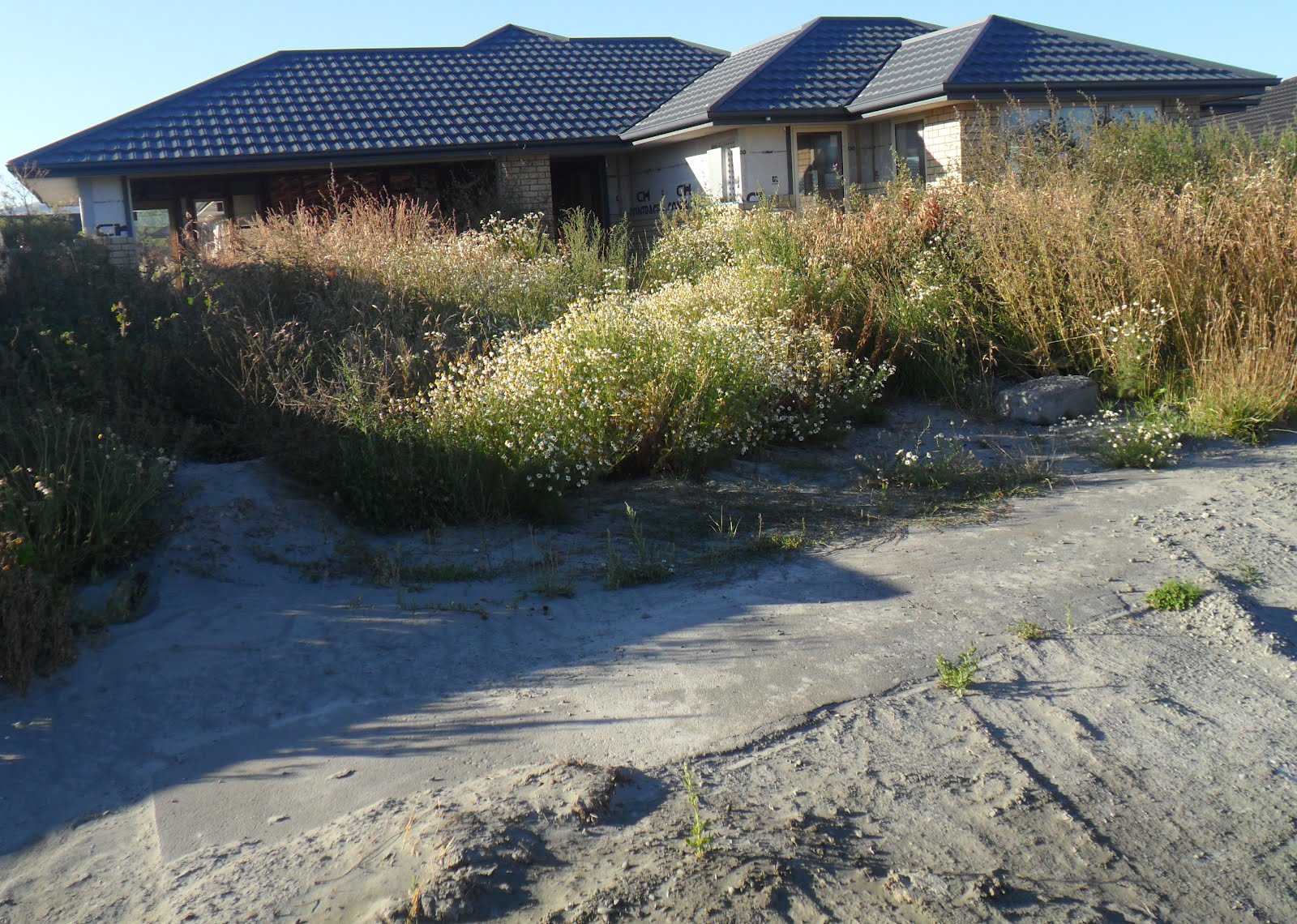
Kingsbridge West was zoned by Council for development before the 2010-2011 quakes, infrastructure was in place. And CERA / Tonkin & Taylor deemed Kingsbridge West green-zone! Post-quakes Kingsbridge West was full of grey quakemire-boils & quakemire-volcanoes. Behind Kingsbridge West's wooden-fence, across Travis Rd was Travis Wetland. Anomaly: Most land / housing on roads I trekked were red-zoned, yet adjacent Kingsbridge West was green-zoned!
All houses I trekked past were relatively new, many were abandoned, some tilted, sunk into grey-quakemire. Excluding Kingsbridge West green-zone anomaly, given that the rest of the roads I trekked were 84% red-zoned, that meant Council cocked-up pre-quakes building-consents & NZ National government was booting red-zoned home-owners out of swamplands!
Brooker Ave: I parked near New Brighton Rd & snapped some liquefaction-sunk ruined-houses in overgrown-gardens. Orange-plastic-road-cones guarded road-damage.

16.01.12. Liquefactioned, red zone housing, Brooker Ave, post 23.12.11 quake swarm


Norcross St, opp Brooker Reserve: Couple of ghost houses. Orange, plastic, road cones guarded road damage.

16.01.12. Liquefactioned Brooker Reserve, viewed from Brooker Ave / Norcross St, post 23.12.11 quake swarm

A Memorial-plaque, BROOKER RESERVE:
STEPHEN AND REBECCA
BROOKER
SETTLED ON 40 ACRES OF LAND BETWEEN
BARKERS ROAD AND BOWER AVENUE IN 1860
BEING ONE OF THE FIRST FOUR FAMILIES
HERE. STEPHEN NAMED THE AREA
"NEW BRIGHTON" AFTER BRIGHTON ENGLAND

Corserland St: I trekked round the bend, then parallel to Anzac Dr by swampland. Liquefaction-dusty, some houses were inhabited, most were ruins in overgrown-gardens. I watched a woman sweeping grey-quakemire off her driveway using a brush & pan.

16.01.12. Liquefactioned Corserland St, post 23.12.11 quake swarm


Longview Pl: A big grey-sinkhole with orange-plastic-road-cones on the corner. Grey liquefaction-dusty, some houses were inhabited, most were ruins in overgrown-gardens.

16.01.12. Green, plastic, sewage tank, liquefactioned Corserland St / Longview Pl, post 23.12.11 quake swarm

16.01.12. Red zone, liquefactioned, Longview Pl, post 23.12.11 quake swarm


16.01.12. Liquefaction sinkhole, Longview Pl / Corserland St, post 23.12.11 quake swarm
I trekked Corserland St again & watched a woman & her barking Doberman vanish into swampland behind houses. Canada geese & other waterfowl floated in the swamp, unfazed by noisy Anzac Dr nearby.

16.01.12. Swampland between Anzac Dr left & Corserland St, post 23.12.11 quake swarm. Mt Evans & Port Hills backdrop

16.01.12. Red zone, quake damaged Corserland St, post 23.12.11 quake swarm


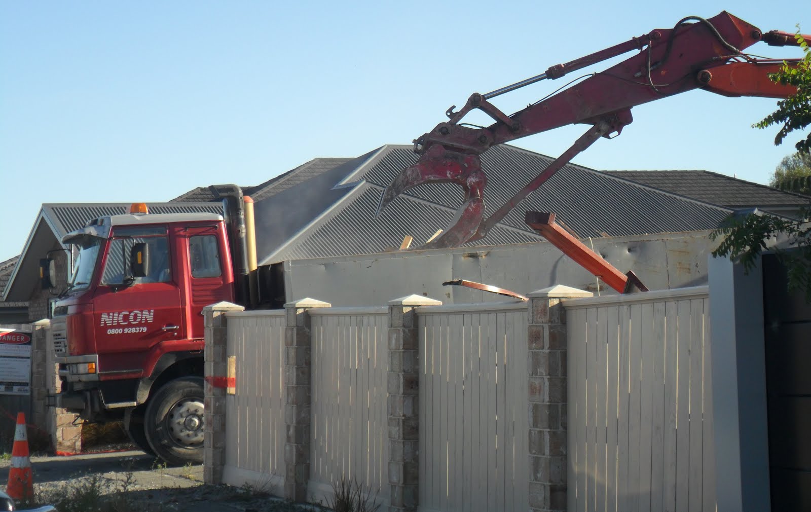
Kingsbridge Dr: Grey liquefaction-dusty, some houses were inhabited, some were ruined in overgrown-gardens. I watched an orange-digger atop a rubble-pile scoop the remains of a two-storey ruined-house into a truck. CERA would demolish many red-zone ruined-houses over the next year.

16.01.12. Green, plastic, sewage tank, Corserland St / Kingsbridge Dr, post 23.12.11 quake swarm

16.01.12. Red zone, liquefactioned house, Kingsbridge Dr, post 23.12.11 quake swarm


16.01.12. Orange digger, demolition of quake damaged, double storey house, red zone, Kingsbridge Dr, post 23.12.11 quake swarm


16.01.12. Red zone, liquefactioned house, Kingsbridge Dr, post 23.12.11 quake swarm


Schumacher Pl: Grey liquefaction-dusty, some houses were inhabited, some were ruins in overgrown-gardens. I looked across busy Travis Rd to Travis Wetland: How many ruined-houses were there? Travis Rd: lumpy, bumpy, patch-repaired, messy.

16.01.12. Red zone, green, plastic, sewage tank, Kingsbridge Dr / Schumacher Pl, post 23.12.11 quake swarm

Earlier that morning, while driving to Anzac Dr along Travis Rd by Basset St, I'd passed a digital road-sign: EARTHQUAKE DAMAGE. Round the traffic-circle on Anzac Dr I'd passed another road-sign: EARTHQUAKE DAMAGE.

16.01.12. EARTHQUAKE DAMAGE road sign, Anzac Dr, post 23.12.11 quake swarm. Port Hills backdrop
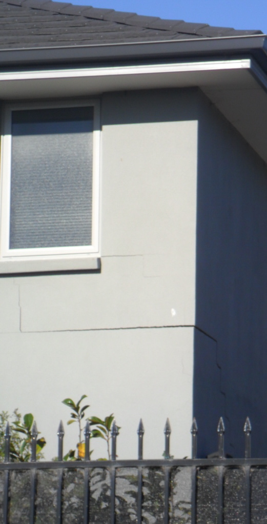
Schumacher Pl: Along a swampland path parallel to Schumacher Pl & Kingsbridge Dr, I detoured round the back of ruined-houses: A new house tilted towards the swamp was split in two, split up an end-wall & straight across the roof. Don't build in wampland!

16.01.12. Red zone, liquefaction damaged house by swamp, Schumacher Pl, post 23.12.11 quake swarm


I passed the orange-digger demolition-site again. An old woman peered through a fence at the demolition. She wore a day-pack & toted a camera.

16.01.12. Orange digger, red zone, demolition of quake damaged, double storey house, Kingsbridge Dr, post 23.12.11 quake swarm


Kingsbridge Dr: I trekked west to Kingsbridge West. The further from Anzac Dr swamp I trekked, damaged housing lessened & the road was cleaner.

16.01.12. Red zone, liquefactioned house, Kingsbridge Dr, post 23.12.11 quake swarm


16.01.12. Waterway footbridge between Kingsbridge Dr & Travis Rd, post 23.12.11 quake swarm

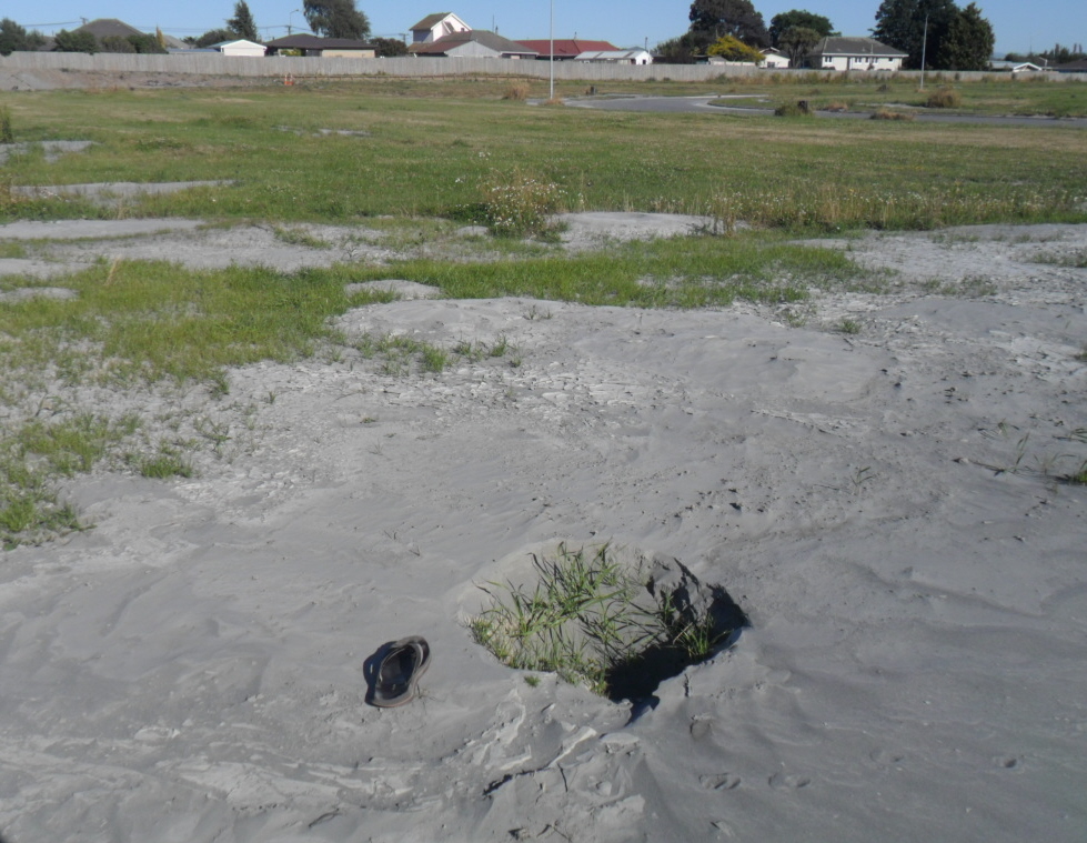
16.01.12. Liquefactioned, Donnell Sports Park, Kingsbridge Dr, post 23.12.11 quake swarm


I trekked past Donnell Sports Park & a waterway going to Travis Rd. On Kingsbridge Dr bend, I snapped a sunken ruined-house, weeds & dry, grey-quakemire in the garden.

16.01.12. Quake sunk, liquefactioned house, Kingsbridge Dr / Kingsbridge West, post 23.12.11 quake swarm


Kingsbridge West: As mentioned above, road & infrastructure was already built, but grey-quakemire polluted mown grass, like Council & developers wanted to flog housing there, on liquefactioned-swampland after 10 000 quakes. Later on, councillor Livingstone would tout Kingsbridge West as cheap-land to sell for affordable-housing. Never mind building on quaked-swampland!
2020. New houses would sell at Kingsbridge West. Council had consented the liquefactioned-land & closely-packed housing (minimum NZ$500 000 RV per house) architects had designed the houses, contractors had built the houses, real estate agents had sold the new houses, buyers had bought their new houses on liquefactioned-land across the road from Travis Wetland.

16.01.12. Liquefactioned Kingsbridge West, post 23.12.11 quake swarm. This green zone, swamp anomaly was amidst red zone swampland. Travis Rd & Travis Wetland was behind fencing


Rebecca Ave: Grey liquefaction-dusty, some houses were inhabited, some were ruined in overgrown-gardens. I passed a house demolition-site occupied by a dusty, grey liquefaction-boil. Demolition-trucks rumbled by spewing grey-dust. A pile of dead carpets mouldered in a dusty driveway. During quake-times, I saw many roadside-piles of muddy-carpets, sure signs that housing was flooded by quakemire. I saw flooding in Jake's Waltham Rd flat after the 22 February 2011 Quake, all carpets had been flooded by a burst well. Anticipating new tenants, the owner just Hoovered the shit-wet carpets!

16.01.12. Red zone, liquefactioned house demolition site, Rebecca Ave, post 23.12.11 quake swarm

16.01.12. Quake damaged house, Rebecca Ave, post 23.12.11 quake swarm


16.01.12. Quake damaged carpets, Rebecca Ave, post 23.12.11 quake swarm


Brooker Ave, back to my car: Grey liquefaction-dusty, some houses were inhabited, some were ruins in overgrown-gardens. A CANTERBURY MOVERS truck was parked in a yard while red-zoners relocated. I saw many mover-trucks over the last year. Streets I trekked that shiny morning were grey-dust smothered. New houses were ruined by quakes. On roadsides I saw grey-quakemire & green-plastic-sewage-tanks. Crappy. Pongy.

16.01.12. Red zone, liquefactioned housing, Rebecca Ave / Brooker Ave, post 23.12.11 quake swarm


16.01.12. Quake damaged housing, Brooker Ave, post 23.12.11 quake swarm


*Trekked Brooker Ave, Norcross St, Corserland St, Longview Pl, Kingsbridge Dr, Kingsbridge West, Schumacher Pl, Rebecca Ave. 184 snaps.
Tuesday 17.01.12. Quake Recovery minister Brownlee announced on TV that orange-zone properties on Southshore between the Pacific & Avon-Heathcote Estuary & white-zone properties in the Port Hills may get a zoning decision by the end of February. For months post-quakes those homeowners were left in limbo by CERA & slow Tonkin & Taylor's land-reporting since zoning began. Red-zoners & green-zoners could get on with their broken-lives, battling CERA / NZ National government, EQC & insurers. But orange-zoners & white-zoners had to suck it up & wait!
Who or what was causing PM Key's "psychological damage" post 23.12.11 Xmas Quake Swarm? CERA / NZ National govt? EQC? Insurers? Fletcher? Quakes? NZ National government wanted to sell public assets. Yet NZ National government was forcing red-zoners off their land with Crown offers at pre-quake 2007 RV. NZ National government didn't say what it would do with the taken red-zone land, a huge asset. Whether red-zoners accepted either NZ National government's buyout option, or insurance payout option, red-zoners were forced by NZ National government's red-zone decree to leave Tonkin & Taylor deemed unfixable-land!
TC3 green / blue-zoners had no such NZ National government buyout offer, having to suck on the dry liquefaction-paps of EQC & / or insurer payouts. 28 000 TC3 green / blue-zoners' long term prospects were grimmer than 7 000+ red-zoners, who could take NZ National government buyout cash & run. TC3 green / blue-zoners were doomed to quakemire-digging quake after quake. Should they stay on ruined land, they were doomed to spend a fortune on reinforced house foundations & no guarantees those foundations would withstand future quakes.
NZ National government speculated on red-zoners' land, either using red-zoners' insurance money to pay out red-zoners for house & land (red- zoners ceded their land / house insurance policies to the Crown) or using taxpayers' money to buy red-zoners' land & leaving red-zoners to sort out house payouts with insurers. Either option, red-zoners lost their land to NZ National government. Thus red-zoners were forced off their land by NZ National government.
Coda:
Government dithering about the future of red-zone land.
Thursday 21 March 2013. Fourteen months later, NZ National government would still be mum about use of its newly acquired red-zone riverlands. CERA minister Brownlee was non-committal. Mainland Press would report a Brownlee spokesman: "The Crown will recover some costs from insurers following the purchase of the red zone residential properties, but decisions on the future use for this land and whether the Crown will gain from these are yet to be made."
November 2013. Ditto March 2013. Many red-zone ruined-houses had been demolished by CERA.
January 2016. NZ National government still stayed mum about what it would do with red-zone land it had taken.
July 2018. Regenerate Christchurch (CERA morph) in the hands of NZ Labour government would burble about what to do with residential red-zone land: Should there be city-to-sea parkland beside Avon River? Definitely no new rowing lake, CERA minister Brownlee's favourite. Public protests followed, favouring a rowing lake.
September 2020. NZ Labour government would begin progressively transferring residential red-zone land to Christchurch City Council.
April 2022. During Easter holidays, I trekked Brooker Ave / New Brighton Rd residential red-zone, viewing public amenity ideas for the residential red-zone. Walkers, joggers & cyclists were about, but none of the amenities were used when I trekked. Amenities were mostly off Brooker Ave en route to Kingsbridge West's post-quake housing development on liquefactioned-land at the end of Brooker Ave. Red-zoned housing was long gone, but trees, shrubs & grass remained behind red-zone fencing:
1. Sportsfield beside New Brighton Rd, combined soccer / rugby goal posts.
2. Concrete paved "road" area for kids to learn road-signs on their bicycles or toy cars.
3. The Barkery: Dog cafe for dog walkers to train dogs, walk dogs & relax on wooden picnic benches by a caravan cafe shop.
4. New native plantings, Brooker Reserve. A board read:
Brooker Avenue
In 2018 we secured a lease of four acres either side of
Brooker Reserve, framed by Brooker Ave and Corsers
Stream. We are developing this site as an exemplar of what
a Forest and Wetland Park in the Red Zone might look like.
Ideally positioned near Travis Wetland and incorporating
the 360 Trail, we hope this site will one day be part of a
dedicated ecological sanctuary, providing an educational
and community-focussed resource for the people and bird
and plant life of Christchurch.
We plant a mixture of dry and wet forest species as well as
maintain the site and develop educational and community
resources and initiatives...
About us
The Residential Red Zone contains
thousands of fabulous trees and shrub specimens, both
exotic and native species and cultivars, that were
once part of former residents' gardens, and now
could become the backbone of an Avon-Otakaro
Forest and Wetland Park.
As a group we have managed to secure ten sites
across the Red Zone that have ecological
significance. We believe in preserving and developing
natural diversity for future
generations and developing the Red Zone in an
environmentally sympathetic manner. As a
volunteer organisation, we maintain these sites
through regular working bees, with some
weedy specimens removed to allow young
native seedlings to develop.
As well as this site, we also look after sites on
Avonside Drive, Waitaki Street and Keller Street
and work closely with the Christchurch City Council
rangers to maintain and develop
Horseshoe Lake Reserve with a working bee
on the final Saterday of every month...
5. Disc Golf field, Disc Golf apparatus on the field.
6. Erected volley ball net.
7. Wild flower patch, a heap of weeds, info board fallen on the ground.
8. Another paved "road" for kids to learn road signs, behind the Disc Golf field.
9. Drone Club field.
10. On a creek bridge, conservation info board:
Waitakiri
EcoSanctuary
Improving lives with nature
CANTERBURY HAS some of the most modified
LANDSCAPES in NZ, but unlike other regions, it has no EcoSanctuary.
Tiny preserved pockets of habitats like Putoringamatu - Riccarton Bush represent what
was lost. Where colonial settlers built, the city was lowland forest... woodlands.
Towards the coast, dunes and salt marsh have been displaced. Christchurch lost 95% of its
wetland habitats along with the wildlife that relied on them.
The river regeneration zone provides a unique
opportunity to restore some of those lost
ecosystems and Waitakiri EcoSanctuary will also
allow for the introduction and care of some of
our most precious and endangered species.
The project boundaries includes Travis Wetland with its 20 years of regeneration and the
... Red Zone where there is high ground for re-foresting. A land-bridge crossing Travis Rd
will link the two halves and a predator-proof fence will encircle the entire site...
August 2023. NZ Labour government would complete transfer of residential red-zone land to Christchurch Council.
See Red zoners 'bullied' in Govt buyout (The Press / Stuff Co).
See CERA / govt offer to red zone residents for insured properties.
See Council is tearing itself apart - Sue Wells (The Press / Stuff Co).
See Liquefaction During Historical Earthquakes in NZ. (Department of Civil Engineering, University of Canterbury).
See Munted there was no dialogue no transparency. Rev Mike Coleman (Stuff Co).
No comments:
Post a Comment