
06.01.12. Green zone, Heath St, Burnside, no liquefaction mud, nor serious damage, after 9 500 quakes, 04.09.10 quake - 23.12.11 quake swarm

Over the last 16 months in Heath St & in Burnside we'd experienced shaking & jolting in 1 000s of quakes, but no liquefaction. No mud.
Eastern suburbs like New Brighton were built on sand or swampland. Post-quakes, eastern suburbs regressed to mud.
The trouble with CERA's land-zoning was that there were anomalies in geotech engineers' Tonkin & Taylors' zoning, as green-zoners in eastern suburbs like New Brighton not only endured shaking & jolting, like us in Burnside, but dug themselves out of liquefaction-mud after quakes. Something stank in CERA's / Tonkin & Taylor's land-zoning.
Continuing my New Brighton treks, I parked by Bowhill Rd / Keyes Rd traffic-circle, wanting to see nearby Baker St, Rawson St & Sinclair St, all mostly green-zoned between Avon River & Rawhiti Domain near the coast.

06.01.12. Serial quake trashed Bowhill Rd / Keyes Rd traffic circle, post 23.12.11 quake swarm
Atrocious Christchurch roads: A traffic-circle was liquefactioned by the 22 February 2011 Quake. Patch-repairs done post-quake. Eleven months post 22 February 2011 Quake, liquefaction raised bricks were stacked on the traffic-circle. Roads were still lumpy & bumpy. Hopefully repaired roads would have new sewage-pipes & water-pipes laid on roadsides, instead of road-centres, as an uncountable number of quake-raised manholes in road-centres were destroying vehicles' suspensions.
By the traffic-circle, I snapped bi-election billboards of prospective councillors including Christ Church Cathedral's dean, Peter Beck who would become a councillor, briefly. Another billboard touted David East who would become a councillor at a later election, after Beck left.
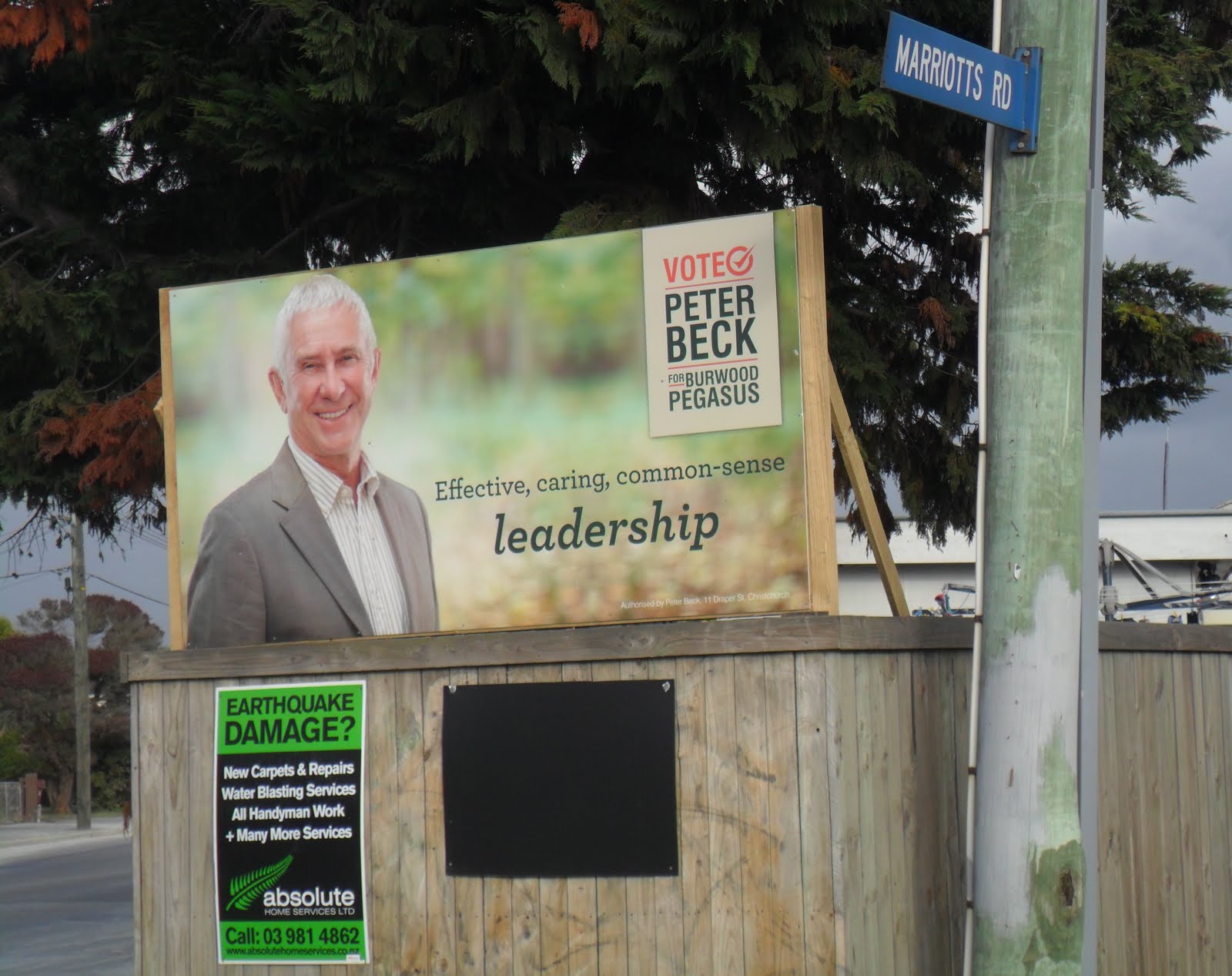
06.01.12. Peter Beck bi-election board, Marriotts Rd / Bowhill Rd, post 23.12.11 quake swarm

Mayor Parker & some councillors voting for invisible CEO Marryatt's salary, $538, 529 p/a, insulted citizens enduring hardships during quakes: deaths; job losses, business losses, home losses; liquefaction-flooding; digging quakemire from properties; water-cuts & power-cuts; destroyed sewage-connections; stinking roadside-portaloos; plastic-sewage-tanks; chemical-toilets; excavation-machinery & demolition- machinery & trucks; sewage-sucker-trucks; negotiations with EQC & insurers & CERA & builders; disintegrating roads; relocations; financial hassles.
Green zoning by Tonkin & Taylor for CERA was crazy, due to Technical Categories: TC1, TC2, TC3. CERA's Landcheck website zoned the following for New Brighton roads I trekked:
Baker St: 176 properties, 169 green-zone, 7 red-zone.
Rawson St: 31 properties, 25 green-zone, 6 red-zone.
Sinclair St: 81 properties, all green-zone.
New Brighton Rd: 249 properties, 2 green-zone, 247 red-zone. (I trekked a bit that day).
Green-zone: Repairs / rebuild could begin.
Red-zone: Land repair would be prolonged, uneconomic. Land to be abandoned, forced relocations. Payout negotiations with NZ National government / CERA & / or insurers.
Those New Brighton streets were quakemired quake after quake. Burnside green-zone housing had no mud post-quakes, no mud digging. New Brighton green-zone had mud digging post-quakes. New Brighton green-zoners would need to spend money repairing house-foundations on shifting-sands, whereas Burnside green-zoners would have less house-foundation expenses on firm shingle.
New green-zone Technical Categories TC1, TC2, TC3 were for house-foundations: Our Burnside house was TC1, no liquefaction, no foundation rebuild. TC3 housing, liquefaction damaged, required foundation rebuilding. About 28 000 houses were green-zoned TC3 by CERA, doomed to foundation repairs due to liquefaction. Doomed to resale hassles. Why were 6 500+ red-zone houses & 28 000 TC3 houses built on dodgy land in the first place? Previous Councils would've known about NZ's quake history.
Biggest anomaly: CERA's geotech engineers Tonkin & Taylor reported that it was OK to build anywhere in red-zoned Christchurch CBD's swampland, despite CBD being a disaster zone on top of Christchurch Fault, ruins everywhere in the CBD's liquefactioned Avon River vicinity. Something stank in the state: Five Tonkin & Taylor staff would be awarded by NZ National government in the 2013 New Year Honours Awards!
I trekked down one side of part-cleaned Baker St & returned to my car along the other side. I saw ruined-houses & overgrown gardens, but most Baker St houses were still inhabited.
Months before, deputy mayor Button defended Council workers doing gardening in the red-zone CBD, while citizens were banned from the CBD. (Still banned 11 months post 22 February 2011 Quake). Button should get Council workers attending to overgrown-gardens, verges & demolition-sites in suburbs where ratepayers lived!
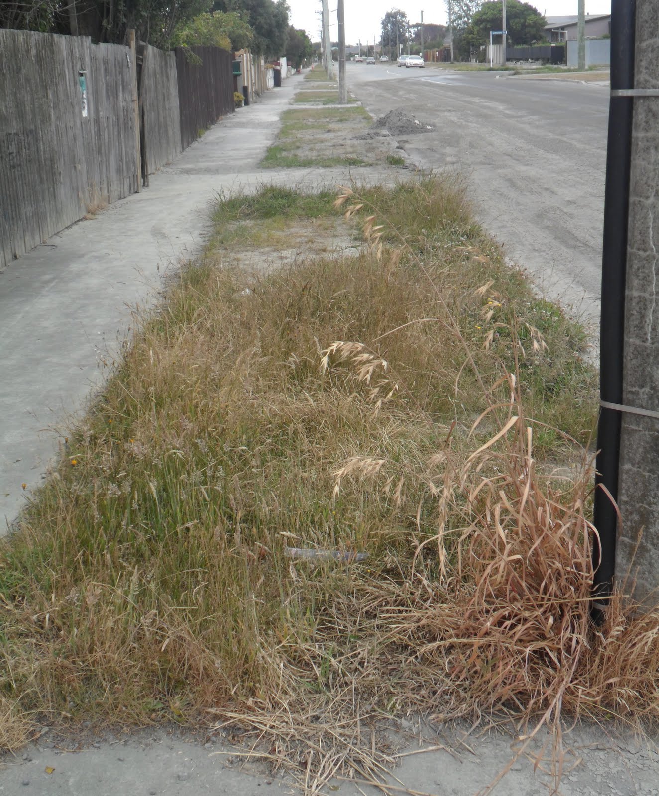
Weedy Christchurch: Post-quakes, natural growth quickly took over demolition-sites & abandoned red-zone properties. That showed pre-quakes, Garden City image had nothing to do with councillors & Ellerslie Flower Show, but had everything to do with ratepayers' gardening pride.
I watched sewage sucker-trucks clearing clogged drains on Dennitt St off Baker St. Sucker-trucks had roamed Christchurch streets ever since the 4 September 2010 Quake, clearing drains & sewage-pipes.

06.01.12. Green zone, green, plastic, sewage tank, Baker St, post 23.12.11 quake swarm

06.01.12. Sucker trucks clearing quake clogged drains, Dennitt St off Baker St, post 23.12.11 quake swarm


06.01.12. Rubbish bin, overgrown garden, Baker St, post 23.12.11 quake swarm

06.01.12. Quake damaged housing, Baker St, post 23.12.11 quake swarm

06.01.12. Green zone, liquefactioned Baker St, post 23.12.11 quake swarm

Baker St: I saw liquefaction-damages to the road-surface & footpaths & driveways. Most of the grey-mud was already cleared by contractors. A water-tanker drove past spraying water. It wasn't much good, as water soon dried & Baker St citizens still enduring liquefaction-dust. On Baker St, I got that creepy feeling again while trekking past ruins.


01.06.12. Orange, plastic, road cone cordon. Green zone, liquefactioned Baker St, post 23.12.11 quake swarm


Baker St / New Brighton Rd: I saw damaged concrete-curbs. Avon River's stopbank-walkway was closed.

06.01.12. Sewage, sucker truck. Liquefactioned Baker St / New Brighton Rd, post 23.12.11 quake swarm


06.01.12. WALKWAY CLOSED. Avon River stopbank, New Brighton Rd, opp Baker St, post 23.12.11 quake swarm

06.01.12. Overgrown garden, Baker St / New Brighton Rd, post 23.12.11 quake swarm


06.01.12. Green zone, liquefactioned pavement & driveway, Baker St, post 23.12.11 quake swarm


06.01.12. Green zone, liquefactioned Baker St, post 23.12.11 quake swarm


Baker St footpath: Between a green-plastic-sewage-tank & a hole by a fence, stinking water leaked across the footpath onto the road. Quakes had degraded Baker St to Third World grey-mud, puddles everywhere. Likewise other eastern suburb streets.

06.01.12. Green zone, liquefactioned Baker St, post 23.12.11 quake swarm

During the 1980s, I'd lived & worked in the Negev Desert, Israel & Namaqualand sandveld, RSA. Desert winds blew sand onto town streets. Sand was cleared by road-maintenance-vehicles. Liquefaction-sand in Baker St & other Christchurch liquefactioned-streets was worse than wind- blown sand I'd seen in desert towns. Desert sand was clean. Grey liquefaction-sand was crappy.

06.01.12. Leaky pipe by green, plastic, sewage tank, Baker St, post 23.12.11 quake swarm


06.01.12. Green zone, liquefactioned Baker St, post 23.12.11 quake swarm


New Brighton Rd to Rawson St: I saw ruined-houses & overgrown gardens: which were fire-hazards & invitations for thieves, squatters & arsonists. Marryatt's precious Council workers should mow!

06.01.12. Red zone, quake trashed house, New Brighton Rd, post 23.12.11 quake swarm


New Brighton Rd / Rawson St: I saw tilted power-poles & a tilted Telecom cubicle near a dairy. The footpath was liquefaction-damaged.

06.01.12. Red zone, quake damaged New Brighton Rd / Rawson St, post 23.12.11 quake swarm


Rawson St: The road & footpath was iquefaction-damaged. Most houses were inhabited, but there were some abandoned houses with overgrown- gardens.

06.01.12. Quake tilted, Telecom cubicle. Green zone, liquefaction damaged Rawson St, post 23.12.11 quake swarm


06.01.12. Green zone, liquefaction damaged Rawson St / Sinclair St, post 23.12.11 quake swarm


Sinclair St: It was quakemired in the 23 December 2011 Xmas Quake Swarm. I saw road-maintenance-vehicles: a yellow McLaren contractor's water-truck; a yellow-tractor with roller-brush & grader-blade; a white Bobcat digger with roller-brush. They all cleared grey-quakemire. I saw some ruined-houses with overgrown-gardens, like a wood-braced house on the road-bend. Most houses were inhabited.

06.01.12. Roads contractor, yellow tractor cleaning 23.12.11 quake swarm mud off green zone, Sinclair St


06.01.12. Green zone, quake damaged Sinclair St, post 23.12.11 quake swarm


Our green-zoned western suburb Burnside was clean. It had no quakemire, no flooding, no dust.
The green-zoned eastern suburb New Brighton was dirty. It had filthy quakemire, flooding & dust.
No wonder CERA invented green-zone TC1, TC2, TC3 categories to include such anomalies. Never mind potential flooding in sunken green-zones after rains.

06.01.12. Green zone, quake damaged Sinclair St, post 23.12.11 quake swarm


Friday 06.01.12, 2.20pm, M5.0 quake, 5km depth, 10km northeast of Christchurch. It rumbled below our Heath St home & jiggled my computer-screen while I typed, strong enough for me to hold the screen steady. It trembled pot-plant leaves on our computer-table. As we lived about 10km from Pegasus Bay, that M5.0 quake's epicentre was about 20km from Burnside.
8.04pm, M4.7, 11km depth, 20km E of Christchurch.
Saturday 07.01.12, 1.21am, M5.2, 15km depth, 20km E of Christchurch (GeoNet). Rocked our house.
Luke told me on Friday afternoon he & girlfriend were walking Avon-Heathcote Estuary's low tide flats when a quake struck. They felt mud moving underfoot & watched marine puddles moving! I warned him to have a tsunami escape-plan: "Run for high ground!"
Saturday evening, 07.01.12. Mayor Parker announced on TV that a long-planned tsunami warning system, with sirens at coastal points from Brooklands around Banks Peninsula\ to Birdling flats would be done.
Pre 2011 Xmas, Royal Commission of Inquiry hearings: Given revelations about a Council suppressed January 2011, McNulty / Griffith report, complaining about Council safety issues when doing red-stickers & yellow-stickers & green-stickers for buildings post 4 September 2010 Quake, I thought Council wasn't interested in safety & health of citizens during quakes, aftershocks & tsunamis. Parker jabbered lots about CBD restart & rebuild plans, but little about citizens' safety.
*Trekked Heath St, Bowhill Rd, Baker St, New Brighton Rd, Rawson St, Sinclair St. 123 snaps.
Coda:
Six months later, in 2012 tsunami warnings would be installed: a series of loudspeakers on power-poles for sirens to blast for ten minutes should a tsunami threaten. A signal for residents to evacuate fast. Sirens would be tested twice yearly, spring and autumn daylight saving days. (The Press 19.06.12).
19.06.12. Baker St residents would want a CERA review for their TC3 green-blue zone housing, as they were unhappy with their green-blue zoning. They wanted to go red-zone, cash in on their damaged properties, instead of waiting years for geotech reports, repairs & inevitable devaluing of their properties.
Baker St & other streets close to Avon River, like Pratt St, Rawson St, Sinclair St, Palmer St, Waygood St, Bower Ave: housing near Avon River was liquefactioned. Liquefaction damage lessened the further properties were from Avon River. All that groundwater caused liquefaction pressure in sandy soils. After months of aftershocks, there would be sliding / tilting / sinking of housing towards Avon River due to lateral spreading & slumping.
Driving along Owles Tce & New Brighton Rd at Avon River high tide, I saw New Brighton Rd had sunk & Avon River bed had risen, as river water-level was above road-level, or at road-level. Just the post-quake stopbank along New Brighton Rd stopped the road & ruined-housing being flooded.
New Brighton Rd was the worst road in Christchurch: potholes, buckling, undulations, patch repairs, flooding.
Although large areas of Christchurch had sunk during quakes, citizens complained about land-zoning by Tonkin & Taylor & CERA, but there wasn't a cheep from CERA about future flooding due to quakes. In future there'd be flooding after rains, in quake-sunk areas, like Flockton Basin, off Warrington St. In 2014 Flockton Basin housing would be flooded several times after heavy rains.
2023. Texting with Luke about buying a post-quake Christchurch house:
Luke: I've been looking at a house for sale on Baker St. I searched online for any information about flooding etc as the house is so close to the river and red-zone. I found your blog post with well documented Baker St destroyed and liquefactioned after quakes. Your post gave me a warning over 10 years ago!
Mark: Baker St was liquefactioned. Many residents wanted their houses red-zoned so they could leave, but their houses were green-zoned! Nearby Avon River just saturates the soil's high water-table, hence all the liquefaction-mud! During quake-times, you kindly paid Blogger for uploading my quake-pics, so your paying-forward saves you from dodgy house sales!
Luke: Your blog confirmed what I was were already thinking. Nice house on a big section, but too risky.
Content & pics Copyright Mark JS Esslemont.
See Parker dismisses abandoning city (Stuff Co / The Press).
See Most Baker St residents want to see red (Stuff Co / The Press).
See $48m plan to stop Flockton flooding (The Press / Stuff Co).
Responded to an email query about a Baker St house.
ReplyDeleteResponded to an email from Canterbury University, Hazard & Disaster Management query, wanting to use photos about the liquefaction cleanup in Christchurch, specifically Rawson St & Sinclair St.
ReplyDelete