I'd seen smaller black rubber-blocks between concrete-bridge-spans & concrete-piers & between concrete-spans & concrete-abutments. But some rubber-blocks on bridges were squashed or squeezed out of position by quakes, leaving concrete to grind & spall on concrete.
Post 4 September 2010 Quake & post 22 February 2011 Killer Quake, Civil Defence used the Art Gallery as HQ while bossing the city during States-of-Emergencies using cops & NZDF-soldier cordons; USAR / TF graffiti; red-stickers, yellow-stickers & green-stickers; citizen bannings & demolitions.
The Press also reported South Library would be closed for strengthening after lateral-spreading & sinking of the library towards Heathcote River. Pre 2010-2011 quakes, the Art Gallery & South Library were new buildings. Leah & I went to South Library on Sunday. On Monday South Library was closed, the same day that Tuam St Library was opened next to the new, temporary Bus Exchange. Library staff from red- zoned Central Library ruin were transferred to the Tuam St library.

Hopefully all the belated closures & expensive fixings of new buildings by Council would make those buildings safe for future earthquakes. Post 22 February 2011 Quake, after 42 300 citizens / month used South Library, why did Council take 18 months to declare it dangerous?
Street Art evolved, seen from Christchurch CBD to Sumner. Examples:
Barbadoes St / Worcester St: A decorated demolition-site showed a defunct piano, two garishly ribboned "Tibetan" prayer wheels, a Youth Hub activity board, painted flagstones & painted planks by a wooden-fence.


Madras St / St Asaph St: A graffiti mural by a demolition-site / carpark.

Madras St: Two bronze, black bulls on bronze, black grand pianos, sculptor Michael Parekowhai. The black bulls were on Edward Gibbon / apex car hire demolition-sites, Madras St, opposite survivor NG Gallery. 2013. The bronze-bull-on-piano sculpture would be bought by Christchurch Art Gallery & would be ensconced in the gallery for its grand reopening in 2015 after years of gallery repairs.


Madras St: 185 Empty Chairs Memorial, Oxford Tce Baptist Church's demolition-site. 185 people were killed by the 22 February 2011 Quake. The 185 Empty Chairs were all painted white by artist Majendie.
The 185 Empty Chairs Memorial would be relocated to St Pauls Trinity Pacific Presbyterian Church's demolition-site opposite CTV's demolition-site, Madras St / Cashel St. 2023. After several moves the 185 Empty Chairs Memorial would be dismantled for good.


Kilmore St / Montreal St, by Cranmer Sq: Giant photos by Hewson on boards covering the steel-mesh-fence-cordoned Cranmer Court ruin: pics of building interiors; people painting; skateboarding; bedding on the floor... Cranmer Court would be demolished in October 2012 after protests. 2023. Cranmer Terraces rebuild on-site.


Kilmore St / Manchester St, St Lukes Anglican Church demolition-site: A brick maze & stone cross made from 185 demolished church stones, another memorial for 185 quake-dead. The brick maze was a copy of Chartres Cathedral maze in France.


A tree-sign:
EARTHQUAKE
MEMORIAL
185 people died as a result of the
22 February 2011 earthquake.
185 precious lives are remembered here,
with 185 pieces of Halswell stone
recovered from St Luke's Church
damaged beyond repair on that day.
May they rest in peace.
St Luke's in the City.

From the stone cross, I looked west across red-zone-CBD demolition-sites, past high-rise ruins to the Town Hall ruin.


Manchester St, outside Rolling Thunder the Harley-Davidson shop: A giant Monopoly game "board" by Helen Trappitt on a demolition concrete-slab showing Manchester St property: two green Monopoly houses & a grey, mini digger.


Manchester St / Southwark St: White / red road-signs on a pole pointing in various directions showing many carparks on demolition-sites.

Moorhouse Ave, August 2012: three orange-diggers, two parked & one working on a rubble-pile by the old station ruin & brick clock-tower (quaked Science Alive & Hoyts). The old station was reinforced-concrete with brick cladding, one of the strongest buildings in Christchurch when it was built to withstand quakes in 1953. The damaged wood-cladded clock-tower had loomed over Moorhouse Ave, steel-mesh-fence-cordons obstructing traffic ever since the 4 September 2010 Quake. The clock stopped when that quake struck. The old station would be demolished.


Colombo St / Byron St, Sydenham: Two demolition-site murals: black work-tools on a yellow background, artist Wayne Youle; three chattering Maori.


Colombo St / Sandyford St: A graffiti mural near a demolition-site. Four seagulls bathed in a demolition-site puddle near Churchills Tavern's demolition-site.


Colombo St / Wordsworth St: A Gap Filler hut on a demolition-site with gardens, wooden-pallet paving, garden games, like noughts & crosses & mini-golf near a temporary coffee shop & two shipping-container shops: a picture / mirror framer; & a dairy backdropped by multi-storey, Sydenham WINZ ruin which would be demolished & replaced by a multi-storey, glassy office-block.
A Gap Filler wall-message:
THE THINGS WHICH
I HAVE SEEN
I NOW CAN
SEE NO MORE


Business as usual, Colombo St, Sydenham was alive, steel-mesh-fence-cordons gone, demolitions completed. Unlike CERA's red-zone-CBD: slow demolitions of high-rise ruins still checkpointed by NZDF-soldiers 18 months post 22 February 2011 Quake.
"Sumner Rocks" on the road to Sumner: Before & beyond Mc Cormacks Bay Causeway, stacked shipping-container-cordons protected traffic from rockfalls. Some shipping-containers had realistic or abstract pics on tarps covering container sides.

Main Rd / Mt Pleasant Rd by Avon / Heathcote Estuary & quake-stunted Shag Rock: Below a cliff, a two shipping-container-cordon with Container Art: two photo-tarps, a flowers pic & a Lyttelton Harbour pic. Orange-plastic-road-cones cordoned the container-cordon. Ruined-houses atop the cliff would be demolished. Years later, hillside above that road corner & Shag Rock would be drilled & blasted for hill terracing, stopping future rockfalls en route to Sumner.


Main Rd below Clifton sea cliff, (ruined-houses were still not demolished by CERA atop the cliff) from quake-stunted Shag Rock to Gollans Point cave: Scores of two-layered shipping-containers formed a rockfall protection cordon, some containers covered by Container-Art, various subjects. A steel-mesh-fence-cordon fronted the container-cordon.


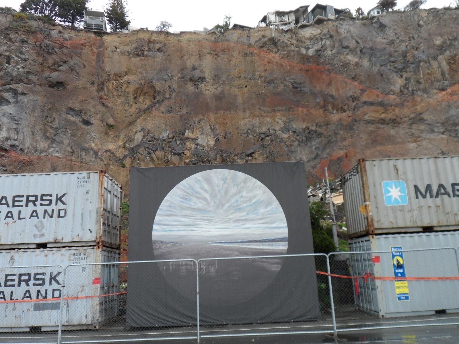


Nayland St / Wakefield Ave, Sumner: More container-art, the two-layered shipping-container-cordon continued along Wakefield Ave. One shipping container was blanketed by knitted woollen-squares opposite a new skateboard-ramp on Sumner Borough Council's demolition-site.


Wakefield Ave: A two-layered shipping-container-cordon protected Sumner from cliff rockfall. There I saw two Container-Art tarps & one floral decorated road-cone.

Clifton Bay / Clifton Tce: Pink shawled rock.

*Trekked Tuam St, Barbadoes St, Madras St, Kilmore St, Manchester St, Moorhouse Ave, Colombo St, Main Rd, Wakefield Ave, Clifton Bay. 92 images.
At the resumed Royal Commission of Inquiry (stopped for a week, a sick commissioner) as to why CTV multi-storey collapsed in the 22 February 2011 Quake killing 115 people, a Texan engineer, professor Mander jabbered about a "vague" government report & bad inspection stickering, post 4 September 2010 Quake by Council inspectors. Mander said CTV should've been closed post 4 September 2010 quake. He reckoned damage caused by quakes before 22 February caused the CTV collapse. He praised CTV design:
"The fact the CTV building survived with only minor visually observable damage is a testament to the efficiency of a design that met the aims and objectives of the design codes. For any structure to survive such a high level of shaking is a bonus. It was certainly not the requirement at the time the CTV building was designed and constructed in the 1980s." (The Press 24.07.12).
Mander opined why CTV collapsed was maybe because joins at concrete-beams & concrete-columns weren't reinforced with steel. He opined it was difficult to see steel at joins after concrete was poured. Mander jabbered about big & small mistakes by builders & engineers, minimising poor design checking & construction checking.
Thursday 26.07.12. Structural engineer Falloon blamed a graduate engineer for a plan to make a refit staircase hole in the CTV second level concrete-slab & said the plan was lost. Falloon didn't take responsibility as boss for signing off the graduate's work. Falloon couldn't remember the graduate's surname! Passing the buck by engineers at the Commission was rife!
Alan Reay & David Harding engineers' buck-passing: Junior engineer Harding did most of the calculations for CTV design saying he hoped for supervision from Reay, his engineer boss. Reay said there was no supervision or review, as Harding was a capable engineer having done infrastructure engineering before rejoining his firm. No-one took responsibility / accountability for their work, nor their subordinates' work!
Friday 26.07.12. The Press: A Royal Commission panel of engineers opined that CTV collapsed due to weak concrete-columns. They couldn't decide if CTV collapsed due to weak concrete-joints, or weak concrete-columns, as their computer modelling only accommodated column investigation, not joints.
Meanwhile, EQC boss Simpson wanted insurers to "increase efficiencies," allowing EQC to exclusively geotech drill 10 000 TC3 green-blue properties. Yet EQC wanted to use only 12 drill-rigs. How long would that take? It was another excuse for insurers to blame EQC for delays so insurers could delay payments. Never mind TC3 citizens waiting years for repairs.
Monday 30.07.12. Early evening protest: Outside Council building, about 300 protestors, representing 28 000 green-blue zone, TC3 home-owners. Inside the Council building, PM Key, CERA minister Brownlee & mayor Parker boasted about CERA's Blueprint for Christchurch CBD!
Isaacs, ex Timaru accountant, ex CERA demolitions boss & 75 acolytes had concocted CERA's Blueprint in 100 days, basing it on Council's Share an Idea scheme done by Council & Cantabrians post 22 February 2011 Quake. Demolisher Isaacs the rebuilder. What?
Tuesday 31.07.12. The Press front page screamed white lettering on red backgrounds:
"GREEN SPACE WILL 'FRAME' A SMALLER CBD." The laterally inverted L Frame, south of Avon River bordering Madras St & St Asaph St would need many more NZ National government / CERA purchases of ruined properties, thus banning citizens from the CBD for many more months of NZDF-checkpoints at red-zone steel-mesh-fence-cordons. The vertical part of the L would become the East Frame / Rauora Park. The horizontal part of the L would become the South Frame of CERA's Blueprint CBD.
Disaster Capitalism: CERA wanted to buy 840 old CBD buildings at market value for its new East Frame parkland, later dubbed Rauora Park.
CERA was already paying residential red-zoners only 2007 Rateable Value, while CERA land-grabbed 1 000s of government red-zoned residential- properties. Government didn't say what it would do with those red-zoned residential-properties.
Where would Manchester St Red Light District go?
Meanwhile, NZ National government had already received a petition signed by 18 500 people proposing AVON / Otakaro Park on downriver red-zoned residential-land ruined by quakes.
Only in 2020 would NZ Labour coalition government, PM Jacinda Ardern, hand red-zoned residential-areas along Avon River back to Christchurch City Council.
More CERA Blueprint edifices to be built on CBD land:
"A NEW CONVENTION CENTRE ON THE SQUARE." (Later named Te Pae). To be built from Victoria Sq to Cathedral Sq, including some of Gloucester St & Craigs House, Victoria Square Apartments, Central Library, Farmers, Chancery Ln & Brannigans demolition-sites. A new Central Library / Turanga would be built on Camelot Hotel demolition-site between Gloucester St & Cathedral Sq.
"A NEW BUS INTERCHANGE," Tuam St.
"A NEW MULTI-PURPOSE STADIUM [roofed] AND METRO POOL AND SPORTS HUB," Barbadoes St & Moorhouse Ave.
"A NEW JUSTICE AND EMERGENCY SERVICES PRECINCT," Tuam St. Never mind The Tower / Court House, Durham St Nth surviving the quakes!
"A NEW PERFORMING ARTS PRECINCT," Colombo St / Armagh St opposite the new Convention Centre / Te Pae & new Central Library / Turanga. That was duplication of nearby Town Hall's performing arts facilities & hotels' convention facilities.
Also reported: a new Maori Cultural Centre to be erected on Crowne Plaza Hotel demolition-site, Kilmore St. (That idea fizzled). More duplication, as there were Maori maraes all over town.
Who would pay?
Regarding CBD court houses by Avon River & Victoria Sq, a Jury Summons letter, Ministry of Justice, I received in June, stated in its pamphlet:
"TOWER BUILDING - 282 DURHAM STREET
After the 22 February earthquake the Tower Building had a 'green sticker.'
An early engineering report stated: The Tower building is of very robust construction. The building performed extremely well and there is minimal damage other than some minor structural damage. Opus International Consultants.
ENGINEER'S INITIAL VISUAL INSPECTIONS WERE FOLLOWED BY HIGHLY DETAILED REPORTS.
*Months of quantitative assessments and geotechnical investigations were undertaken at this building.
*The Ministry's engineering work confirms that the Tower Building is a low-risk building.
*The Canterbury Earthquake Recovery Authority has reviewed our engineering reports and has no structural engineering concerns over occupation of the Tower Building..."
2022. Tower Building, 282 Durham St Nth, would be occupied by Huadu International Management Group & Huadu Education.
NZ National government would pay for the new Justice & Emergency Services precinct, Tuam St & new Convention Centre / Te Pae, Cathedral Sq. So far, it was vague who would pay for the roofed stadium, Madras St; Metro Sports Facility, Moorhouse Ave; new, Central Library / Turanga, Gloucester St. (Central Library would cost $100m, mostly paid by Council). Never mind confusion over the New Performing Arts Precinct & ruined Town Hall.
CERA minister Brownlee hinted that Council must sell revenue producing assets like Christchurch Airport, Lyttelton Port, Orion utility, City Care... to pay for CERA's Blueprint CBD rebuild, despite Council assets giving profits & keeping rates low. (The Press, Wed 01.07.12).
Later on NZ National government would sign an agreement with Council as to who would pay for CERA's Blueprint precincts. Whether paid by NZ National govt, or Council, or shared payment by both, NZ National govt was forcing Council to pay for CERA's Blueprint precincts without costing CERA's Blueprint precincts properly. Never mind that ratepayers would have increased rates forced on them to pay for NZ CERA's Blueprint precincts.
Isaacs & his CERA gang of Blueprinters forgot to mention surviving CBD businesses on core CBD fringes, within the four avenues. Were all those surviving businesses in & outside the Green Frame no longer CBD? Isaacs' "need to shrink the commercial heart of the central city" to increase value of Blueprint CBD properties was a con, as CERA needed Green Frame property-owners selling their CBD properties to the Crown. Crown purchases of Frame land would be subsidized by taxpayers too. If I was one of the many car dealers in the Blueprint South Frame being forced by Issacs & his Blueprint gang to sell my car business to the Crown for core CBD businesses to profit, I would be extremely unhappy!
Isaacs's & Brownlee's Blueprint precincts would need demolishing of survivor buildings, like Central Library for Te Pae Convention Centre & demolishing of quick rebuilds like Westende House in the new Green Frame to enable East Frame, Rauora Park.
Never mind Christchurch Art Gallery, Montreal St, needing repairs; Arts Centre, Worcester Blvd, needing repairs & Canterbury Museum, Rolleston Ave, needing repairs. And the Museum already had Maori & pakeha exhibits.
Also reported: New Cricket Oval would swipe a bit of Hagley Park. Cricket authorities jumped on the gimme-gimme bandwagon, ex Black Cap, Lee Germon saying the new Cricket Oval was needed for international matches. But there were other cricket venues in Christchurch. (Despite protests, Hagley Park Cricket Oval would be used for 2015 World Cup cricket).
What next? Straighten out Avon River, as Brownlee desired for an Olympics rowing course? (At the end of 2013, Brownlee would warm to that fantasy, suggesting Christchurch as the "Sports Capital")!
Also reported: Health Precinct, Christchurch Hospital environs. IT Innovation Precinct, St Asaph St. Residential Demonstration Project, Madras St. Avon River Precinct, CBD river banks would be revamped parkland by Council. Margaret Mahy Family Playground, where Centennial Pool & other ruins once stood.
CERA's Blueprint CBD would be rebuilt on ruined CBD swampland, atop Christchurch Fault, where hundreds of old buildings were liquefactioned & ruined. CERA would repeat Victorians' mistakes by Blueprinting a new CBD on swampland! Great irony: CERA had already red-zoned thousands of houses on Avon River swampland forcing citizens to leave their properties.
Who checked CERA's ex Timaru accountant, latter day demolisher Isaacs? Silent CERA boss Sutton? Isaacs continued his demolition lust, wanting to demolish many buildings in the Green Frame, like Calendar Girls, reopened post-quakes & other night clubs. Isaacs forgot night clubs brought money to Christchurch.
Anglican's new Cardboard Cathedral, St Johns demolition-site, would be next to CERA's Blueprint stadium, Hereford St / Madras St, by Latimer Sq. What a crock!
Despite the reduced Blueprint CBD, citizens were banned from the red-zone-CBD since the 22 February 2011 Quake, by steel-mesh-fence-cordons & NZDF-checkpoints. Citizens were banned seeing for themselves the extent of CBD ruination. Neither could citizens decide for themselves (unhindered by CERA) whether the Blueprint was valid & fair, as citizens weren't consulted about CERA's Blueprint. Isaacs disingenously muttered about reduced value of post-quake CBD properties.
Why was CERA building its Blueprint CBD on top of Christchurch Fault which ruined Cashel Mall during the Boxing Day Quake, 2010? Eastwards, Christchurch Fault lurked under Barbadoes St waiting for CERA's Blueprint 35 000 seater, roofed stadium to be built. Never mind CTV multi-storey collapsing nearby, Cashel St / Madras St. CTV demolition-site was across Madras St from the proposed new stadium. Imagine the carnage should another quake hit the Blueprint 35 000 seater stadium while the stadium was in use! Never mind traffic-jams & parking congestion created in the CBD during stadium use. And noise pollution: crowds roaring, triumphant bands playing, guitars, tambourines, drums, trumpets galore...
Meanwhile Riccarton Rd, Blenheim Rd, Lincoln Rd had absorbed business relocations from the ruined CBD long before CERA touted its Blueprint CBD on swampland above Christchurch Fault.
Despite CERA's Blueprint hype, nearly two years post 4 September 2010 Quake, roads were still ruined & ruined Avon River bridges were not fixed yet.
Content & pics Copyright Mark JS Esslemont.
See Library closure king hit for regular users (The Press / Stuff Co).
See Govt report into CTV collapse vague (The Press / Stuff Co).
See No evidence of CTV steel reinforcing (The Press / Stuff Co).
See No critical damage to CTV from 2010 quake (The Press / Stuff Co).
See EQC wants to take over all drilling (The Press / Stuff Co).
See Ratepayers to fund big ticket items (The Press / Stuff Co).
See Public pay more than once thought for Christchurch's delayed Central Library (Stuff Co).
No comments:
Post a Comment