
31.03.11. Steel mesh fence cordon. Feb 22 quake toppled, brick parapet, Ferry Rd, national state of emergency. Bldg would be demolished
CERA, Christchurch Earthquake Recovery Authority, a new government department, was established on 29 March 2011. CERA would rule Christchurch for the next five years.
I turned right into bumpy Aldwins Rd & drove past footpath-portaloos to Buckleys Rd / Linwood Ave crossing, where I stopped by Eastgate Mall. Last week I'd coolpixed ruins at Linwood Ave / Aldwins Rd. A week later, all that was left was a demolition-site, half- demolished brick-ruins & a yellow-digger parked behind a steel-mesh-fence-cordon. A new Burger King would be built on-site. Would safer buildings be delivered during CERA's five year tenure?

31.03.11. Orange, plastic, road cones, steel mesh fence cordon. Yellow digger, Feb 22 quake, demolition of old, brick shops, Linwood Ave / Aldwins Rd, national state of emergency. A Burger King was rebuilt on site
Buckleys Rd: Eastgate mall scaffolded. Two workmen on an expander-ladder by countdown wall, epoxy-glued cracks, then painting over. During the next few years I would see many cracked concrete-walls, epoxy-glued. Patch-jobs. Opposite Eastgate Mall: a broken, brick, garden- wall, brick-rubble on footpath by a bus-stop. Quakemire-dust lay all along Buckleys Rd.

31.03.11. Buckleys Rd, Eastgate mall, national state of emergency

31.03.11. Steel mesh fence cordon. Feb 22 quake cracks repaired, countdown, Buckleys Rd, national state of emergency

31.03.11. Feb 22 quake collapsed, brick, garden wall & bus stop, Buckleys Rd, national state of emergency
Buckleys Rd, near Rhona St & Wyon St crossings: Five toppled, concrete-brick garden-walls. Concrete-brick rubble lay in gardens. A fallen brick-chimney, the brick-base was wood-braced. Also, two toppled concrete-brick, garden-walls near Dacre St.

31.03.11. Quake toppled, concrete brick, garden wall, Buckleys Rd, national state of emergency


31.03.11. Quake toppled, concrete brick, garden wall, Buckleys Rd, national state of emergency

Pages Rd / Woodham Rd: Waipuna Youth & Community Centre, 22 February 2011 quake fallen, concrete-brick garden-wall on the opposite corner. Two blue-portaloos on footpath outside the Early Childhood Centre. Quakemire-heaps & sodden-carpets on Pages Rd footpath. Green-plastic-sewage-tank on the footpath. A threat-sign:
HUMAN WASTE
ONLY
WASH HANDS AFTER DISPOSAL!!
BEWARE OF SPLASHBACK!!
A white-plastic-bottle of hand-sanitiser was black-taped to the sewage-tank. I would see BEWARE SPLASHBACK signs on green-plastic-sewage-tanks all over Christchurch. Tricky to wash hands after shit-disposal when sewage-pipes & water-pipes burst, mixing sewage, water & quakemire. Shit-oozing-portaloos, hand-sanitiser smells & shit-full, plastic-sewage-tanks would accompany my cordon-treks for months.

31.03.11. Feb 22 quake collapsed, concrete brick, garden wall, opp Waipuna Youth and Community Centre, Woodham Rd / Pages Rd, national state of emergency

31.03.11. Blue portaloos, Waipuna Youth and Community Centre, Woodham Rd / Pages Rd, national state of emergency
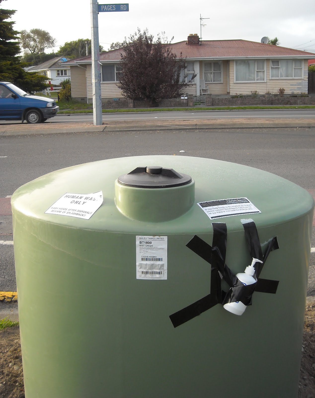
31.03.11. Feb 22 quake, green, plastic sewage tank, Woodham Rd / Pages Rd, national state of emergency


31.03.11. Feb 22 liquefaction silt & trashed carpets, Pages Rd, Waipuna Youth and Community Centre, national state of emergency
Post-quake Avon River was an open sewer. 1 000s of portaloos & green-plastic-sewage-tanks polluted Christchurch. They stood on footpaths wherever there was broken housing & broken sewage-pipes.
Pages Rd: Uneven road-surface between Waipuna Centre & Supershed Reuse Warehouse. Pages Road Market, Open Thursdays: wares for sale on trestle-tables, clothes hung in the open air. A Cronos water-tank & two shipping-containers stood at the market. Cars & three white campervans were parked in the quakemired-carpark near the Marae: Te Runanga o Nga Maata Waka, Urban Maori Authority. I snapped Maori carvings at the marae gate.

31.03.11. Pages Rd, Thursday Market, national state of emergency

31.03.11. Pages Rd, Marae gate, national state of emergency

Pages Rd / Breezes Rd: Mobil garage closed, steel-mesh-fence-cordoned. (Closed for months). Opposite corner, On The Spot shop & Fish 'n Chip & Burgers ruined-shop: fallen side brick-wall on squashed cabbage trees. Exposed rooms. Brick-rubble in garden. DANGER KEEP OUT plastic-barrier-tape lay on rubble, an ineffective cordon. Rotten-food-stench wafted: I became used to that stench when trekking past ruined-shops. The Fish 'n Chip shop would be demolished.

31.03.11. Feb 22 quake closed, steel mesh fence cordoned, Mobil garage, Breezes Rd / Pages Rd, national state of emergency

31.03.11. DANGER KEEP OUT. Feb 22 quake trashed Fish n Chips & Burgers shop, Pages Rd / Breezes Rd, national state of emergency. The shop would be demolished


31.03.11. Orange, plastic, road cones & steel fence cordon. Road pipe excavation & repairs, after Feb 22 quake liquefaction, Marlow Rd, national state of emergency


Marlow Rd off Pages Rd: Water-pipe excavation & repair: white, blue & red, plastic-pipes lay on the footpath. Three Hi-Vis vested workmen connected a drainage-pipe. A white-digger dumped earth onto a grey-heap, orange-plastic-road-cone-cordoned. Several parked trucks.
Pages Rd: A yellow Waste Away tanker drove by. Portaloos & green-plastic-sewage-tanks roadside. Dusty, dried quakemire by snapped, concrete-curbs & displaced iron-drain-grilles.

31.02.11. Yellow portaloo, Feb 22 liquefaction damage by drain pump station, Pages Rd / Porchester St, national state of emergency


31.03.11. Feb 22 quake tilted house by drain pump station & yellow portaloo, Pages Rd / Porchester St, national state of emergency


 Pages Rd / Porchester St junction: Pages Rd descended into Bexley Swamp. Why were houses built there?
Pages Rd / Porcester St opposite Bexley Reserve: Yellow portaloo on quakemire. A green house, tilted towards a drain-pump- station, also tilted towards the green house. An above-ground, black-plastic-pipe pumped sewage from another house behind. A blue-pump pumped beside the damaged, brick, pump-station. Cracked concrete-curbs, broken-drains, raised iron-grilles, broken-roads & broken-footpaths.

31.03.11. Yellow portaloo, Feb 22 quake tilted house & drain pump station, Porchester St / Pages Rd, national state of emergency


31.03.11. Feb 22 quake, blue pump by damaged, brick, pump station, Porchester St / Pages Rd, national state of emergency


Pages Rd: Porchester St to New Brighton Rd & Owles Tce roundabout: Road repairs in progress.

31.03.11. Man digging Feb 22 liquefaction silt from verge opp Bexley Reserve, Pages Rd, national state of emergency

31.03.11. Blue portaloo, Feb 22 quake damaged houses, opp Bexley Reserve, Pages Rd, national state of emergency

Pages Rd, Bexley Reserve entrance: Road liquefaction-damage & repairs. An orange-digger & white-sucker-truck were parked roadside. On footpath: green-plastic-sewage-tank with white-plastic hand-sanitiser bottle attached. Portaloo on footpath. House-wall was wood-braced. A man dug silt by a garden-wall. Silted-carpets lay by a tilted garden-fence.

31.03.11. Green, plastic, sewage tank, Bexley Reserve entrance, Pages Rd, national state of emergency

31.03.11. Orange, plastic, road cone cordon. White, sewage tanker by Bexley Reserve entrance, Pages Rd, national state of emergency

31.03.11. Orange, plastic, road cone cordon. Orange digger, Bexley Reserve entrance, Pages Rd, national state of emergency
Farnborough St off Pages Rd: Portaloos, quakemired carpet-piles & house-rubbish on footpaths. Broken garden-walls. Cracked- driveways. Quakemire-heaps roadside. Broken concrete-curbs, displaced iron-drain-grilles. Green-plastic-sewage-tank on footpath. Another in a park at road's-end. Shingle-repairs to road, tarseal pending.

31.03.11. Yellow portaloo, quake damaged Farnborough St off Pages Rd, national state of emergency


31.03.11. Feb 22 liquefactioned carpets, Farnborough St, national state of emergency

31.03.11. Feb 22 quake rubbish on pavement, Farnborough St, national state of emergency

31.03.11. Feb 22 quake damaged, concrete brick, garden wall, Farnborough St, national state of emergency


Most "repaired" roads I saw in Aranui & Bexley were patched, or shingled, or unsealed.
Pages Rd to Anzac Dr: Congested-traffic. Patchy road-works, shingled. Earthmoving-machines: digger, trucks, road-roller... I crossed open-sewer Avon River on Pages Rd Bridge & circled the roundabout by New Brighton Rd & Owles Tce back onto Pages Rd. Turned left into Wairoa St, Bexley, along Avon River.
Wairoa St: Bexley roads I drove had portaloos on footpaths, signifying broken sewer-pipes. Most roads were being repaired, like Wairoa St, full of workmen & road-repair vehicles. e.g. A high-pressure water-blasting truck blasted silt from underground sewage-pipes. In hindsight, repairs were futile, as CERA would soon red-zone many roads I trekked that day.
Wairoa St / Morganwood St: White-plastic-water-tank; portaloo; green-plastic-sewage-tank, white-plastic hand-sanitiser bottle attached; eight portaloo showers in a navy-blue shipping-container at Bexley Wetland entrance near Avon Estuary. When I opened the temporary shower-facility door, a homeless man lay on the shipping-container floor. He'd slept the night there. Avon River bank was slumped due to lateral-spreading.

31.03.11. White, plastic, water tank, Wairoa St / Morganwood St, Bexley, national state of emergency

31.03.11.Green, plastic, sewage tank, Wairoa St / Morganwood St, national state of emergency

31.03.11. Eight showers in a portaloo shipping container, Wairoa St / Morganwood St, national state of emergency. Temp refuge for a quake-homeless man

31.03.11. Wairoa St view, Feb 22 quake crackled footpath & slumped, Avon Estuary bank, national state of emergency. Slumping was due to lateral spreading
Seabreeze Cl in Bexley Wetland was trapped by rumbling Bexley Rd traffic westwards & Avon Estuary eastwards. Lovely wetland views, but a bad place to build. Post-quake Bexley sank into Avon River swamp-mud, never mind quakemire, rising sea-levels & climate- change.
Seabreeze Cl post 22 February 2011 quake was worse than what I saw post 4 September 2010 quake: Deserted; grey quakemire everywhere; pools on the cracked-road; crumpled-driveways; abandoned, broken-houses. Four EQC inspectors roamed. My digital-snaps made up for those I'd missed six months before.

31.03.11. New stopbank / cycle track, between Bexley Wetland & Bexley Rd, national state of emergency

31.03.11. New stopbank between Bexley housing & Bexley Wetland, national state of emergency

31.03.11. Liquefaction boils in Bexley Wetland by new stopbank / cycle track, national state of emergency

31.03.11. Liquefaction boil in walkway between new Bexley Wetland stopbank & Bexley housing, Seabreeze Cl, national state of emergency

31.03.11. Feb 22 quake tilted house, Bexley Wetland, national state of emergency

31.03.11. New stopbank / cycle track, between Bexley Wetland & Bexley housing, national state of emergency

Seabreeze Cl: I circuted Bexley Wetland & Avon Estuary, along various roads & Morganwood St back to Seabreeze Cl: A new stopbank / cycle-track snaked between Bexley Wetland & houses. Useless as tsunami protection, or Avon Estuary flooding. Risible against future quakemiring, as Bexley Wetland was already quakemired. Bexley roads I'd seen were all liquefactioned away from Avon River & Avon Estuary.
Post 4 September 2010 quake, I'd seen the gravel footpath below the new stopbank liquefactioned & cracked, so future quakes would just liquefaction the stopbank / cycle-crack again. Engineers just dumped new shingle on top of the liquefactioned-footpath. Post 22 February 2011 quake, what were engineers thinking?


31.03.11. Feb 22 quake damaged house with huge quake crack in yard, Bexley Wetland, national state of emergency

31.03.11. Feb 22 quake, 6 foot wide crack in house yard, Bexley Wetland, national state of emergency


31.03.11. Yellow digger between old & new stopbanks, Bexley Wetland, national state of emergency
The heightened stopbank enabled walkers & cyclists to look straight into ghost-houses lining Bexley Wetland, privacy nil for those staying post-quake. Most houses were abandoned: No children, no adults, no traffic.
Creepy feeling again: Silence, emptiness, aching air, fear that another quake would catch me near a building. Spooked by ghosts, I was super-aware of my closeness to unstable-walls while trekking cordons. I was ready to sprint. Some houses I passed were tilted & abandoned. One back-yard had a six foot wide crack right across. Closer to Avon Estuary I came upon an older, smaller stopbank I'd trekked a year before.
Seabreeze Cl: New houses, swamped by quakemire: 4 September 2011 quake, 22 February 2011 quake, later 13 June 2011 quake. Giveaway, silt- level on house-walls & fences after silt-excavations. Student gangs had dug away silt, together with mechanical diggers. Silt was quickly dumped, authorities hiding their sins. Houses were swamped, once, twice, thrice. No wonder Seabreeze Cl would be abandoned & red-zoned: Cracked-road, cracked-driveways, ruined-houses. White-plastic-water-tank on three stacked, blue-pallets. Orange-digger was parked nearby. Blue- portaloos & quakemire-heaps on footpaths. Liquefaction-dusty road & dusty-alleys. Quakemired-carpets & house-junk heaped roadside. Brown shipping-container by one house, ready for relocation. Red-lidded, yellow-lidded, green-lidded Council bins on footpaths & driveways. Some driveways still quakemired. Scattered grey-puddles. Cracked concrete-curbs. Concrete-manhole-casing pushed a foot above footpath level. Broken wooden-fencing between houses. Fallen brick gate-post...

31.03.11. White, plastic, water tank & orange digger, Seabreeze Cl, Bexley, national state of emergency

31.03.11. Feb 22 quake damaged Seabreeze Cl & blue portaloo, national state of emergency


31.03.11. Feb 22 liquefaction destroyed carpets & blue portaloo, Seabreeze Cl, Bexley, national state of emergency

31.03.11. EQC inspectors, off Seabreeze Cl, Bexley, national state of emergency


31.03.11. Sept 4 & Feb 22 quake trashed houses, Seabreeze Cl, Bexley, national state of emergency. See silt level on walls, fences, bin, after silt excavation


Seabreeze Cl sunk into Bexley Wetland: Harsh, sunny afternoon while trekking alone, snapping, spooked by ghost-houses surrounded by grey- quakemire, mostly cleared. Silt-stains on fences & walls were about one foot high: three / four brick-courses high!

31.03.11. Serial quake trashed housing, Seabreeze Cl, national state of emergency. See silt level on walls / fences after silt excavation


31.03.11. Serial quake trashed housing, Seabreeze Cl, national state of emergency. See silt level on walls / fences after silt excavation


Six months post 4 September 2010 quake, six weeks post 22 February 2011 quake, I still got angry when thinking about Council consenters who'd allowed development at Seabreeze Cl & nearby roads, close to Bexley Wetland & Avon Estuary. All those councillors, planners, consenters, surveyors, architects, designers, drawing office personnel, engineers, developers, builders, real-estate agents, banks had much to answer for, ripping off home-buyers. Never mind home-buyers' due diligence.

31.03.11. Serial quake trashed housing, Seabreeze Cl, national state of emergency. See silt level on fences / walls after silt excavation


Velsheda St / Wetlands Gr: Yellow & blue portaloos on footpathss Road-workers wearing Hi-Vis vests & hard hats did road-repairs: yellow McClaren tractor with road-scraper-blade, yellow McClaren shingle-truck, white Bobcat digger, white Interflow tanker, "Leaders in Pipeline Renewal." Contractors made megabucks patching Christchurch broken-roads: Sucking-sludge, making shingle-patches, tarseal-patches, patches on patches, pothole-patches, sinkhole-patches, pipe-excavation-patches.

31.03.11. Yellow portaloo & Hi-Vis vested workman by white tanker, water blasting liquefaction silt out of road pipes, Velsheda St / Wetlands Gr, Bexley, national state of emergency


31.03.11. Blue portaloo, post Feb 22 quake road contractors repairing Velsheda St, Bexley, national state of emergency


Morganwood St by Harold Henry Park: A white, portable power-generator stood on the footpath. Like other Bexley streets, Morganwood St had damaged curbs, drains, footpaths & driveways. Quakemire-heaps, green-plastic-sewage-tanks with white, hand-sanitiser bottle & portaloos stood on footpaths.

31.03.11. White generator on pavement, Morganwood St, national state of emergency

31.03.11. Feb 22 quake damaged curb & drain, Morganwood St, Bexley, national state of emergency


31.03.11. Green portaloo, Morganwood St, national state of emergency

31.03.11. Feb 22 quake damaged pavement & driveway, Morganwood St, national state of emergency

31.03.11. Liquefaction silt & green, plastic, sewage tank, Morganwood St / Wetlands Gr, Bexley, national state of emergency
Pages Rd: I crossed Pages Rd Bridge over open-sewer Avon River to Anzac Dr, to snap 22 February 2011 quake damage.

31.03.11. Feb 22 quake damaged roads, Pages Rd / Wairoa St, & abutment join to Pages Rd Bridge, national state of emergency
Pages Rd Bridge: Road cracked at abutment-joins both sides of the bridge.
Pages Rd: Yellow-portaloo & green-plastic-sewage-tank on footpath opposite Domino's Pizza ghost. Nearby houses: broken garden-walls, cracked-driveways, tilted garden-gates, quakemire, brick-rubble in gardens.

31.03.11. Yellow portaloo, Pages Rd by Domino's Pizza, national state of emergency

31.03.11. Feb 22 quake liquefactioned business nr Domino's Pizza, Pages Rd, national state of emergency. The business would be demolished

Onepu St: Road repairs progressing.

31.03.11. White water tanker spraying to lay liquefaction dust, Waitaki St / Pages Rd, national state of emergency

Waitaki St: Road repairs progressing, digger & truck parked in street. Shingle-heap, quakemire-heap in street. Post 4 September 2010 quake: road flooded. I would return another day for snapping Pages Rd, Waitaki St, Bexley Rd damages.

31.03.11. Yellow portaloo, Kia Ora St / Pages Rd, national state of emergency
Kia Ora St: Road repairs progressing. Pages Rd houses between Kia Ora St & Bexley Rd were liquefactioned, silt everywhere. Two men dug silt from a garden & dumped barrow-loads onto the footpath. Snag with Council road-works & silt-diggings: in future CERA, after delays, would red-zone Bexley by Avon River, wasting all those house-repairs & Council silt-diggings. At that early CERA stage of my Bexley trek, there was no CERA residential red-zoning or green-zoning, homeowners were in limbo.

31.03.11. Fallen brick, garden wall. Feb 22 quake, liquefaction damaged houses, pavement & Pages Rd, Bexley, national state of emergency


Pages Rd / Bexley Rd: Orion power substation had an excavation trench with underground line-repairs.

31.03.11. Post Feb 22 quake, Orion utility repairs, Pages Rd / Bexley Rd, national state of emergency

Pages Rd / Anzac Dr: Blue-portaloo on footpath. Concrete-block supported a tilted power-pole. Department of Corrections ghost was quakemired, stone gate-post tilted in deep mud. Like the Probation Service building at Winston Ave, the Dept of Corrections building at Pages Rd was closed.
Yellow-wall blue-sign:
OFFICE CLOSED
Please report to
Nga Hau E Wha Marae
250 Pages Road
Freephone...
Department of Corrections wall, orange spray-painted threat-sign:
DANGER
KEEP OUT
The building would be demolished.

31.03.11. Quake tilted, stone, letterbox pillar. Feb 22 quake, liquefactioned bldg, Corrections Dept closed, Pages Rd, national state of emergency. Corrections Dept bldg would be demolished


31.03.11. DANGER KEEP OUT. Feb 22 quake cracked, Corrections Dept bldg, Pages Rd, national state of emergency. Corrections Dept bldg would be demolished

31.03.11. Feb 22 liquefaction silt heap. Concrete block supporting a quake tilted, power pole, Pages Rd / Anzac Dr, national state of emergency

31.03.11. Blue portaloo & Feb 22 liquefaction silt, Pages Rd / Anzac Dr, national state of emergency
Drove Pages Rd back to Porchester St, did a short, circular-drive through Bexley.
Porchester St / Corhampton St junction: Wood-braced house-wall. Two-storey house, grey-tiles displaced on roof. Road-repairs progressing.

31.03.11. Quake damaged houses, Porchester St / Corhampton St junction, national state of emergency
Carisbrook St: Road-repairs progressing.
Warblington St: Road-repairs progressing.

31.03.11. Brown portaloo opp Seventh Day Adventist Church, Pages Rd, national state of emergency


31.03.11. Post Feb 22 quake kiosk, Seventh Day Adventist Church, Rowan Ave / Pages Rd, national state of emergency

Pages Rd / Rowan Ave: Brown-portaloo on Pages Rd, opposite Seventh Day Adventist Church, zig-zag cracked, concrete-brick corner-walls, plastic-barrier-tape-cordoned. Op shop alongside was open. In the church-yard, the white-plastic-tented, Recovery Information Kiosk was open, no one attending. Brown shipping-container, green & blue portaloos behind. A white-plastic-water-tank stood by the gate. Cardboard-boxes lay on pallets, one plastic water-bladder remained.
Water-tank sign:
PLEASE TAKE A
MAXIMUM
OF 2 BLADDERS
THERE IS NO NEED TO STOCKPILE WATER
AS WE'LL BE HERE FOR A WHILE YET AND
WILL CONTINUE TO PROVIDE WATER FOR YOU
Bexley was in shit: broken sewage-pipes, broken water-pipes.

31.03.11. Feb 22 quake, white, plastic, water tank, Rowan Ave, national state of emergency


I drove back to Burnside via Woodham Rd: In Linwood North School garden, a brown-plastic-water-tank had white spray-painted words: WATER BOIL B4 USE. It summarized our post-quake water-supply: Liquefaction boils, sewage & water mixing, water-borne disease threat.

31.03.11. Water Boil B4 Use. Post Feb 22 quake, brown, plastic, water tank, Linwood North School, Woodham Rd, national state of emergency
Woodham Rd / Gloucester St: I filled up with petrol at the BP garage. I snapped two-storey ghost-shops nearby, damaged in the 4 September 2010 quake, ruined in the 22 February 2011 quake: Brick-parapets fallen, roof-spaces exposed, verandah-awning part-collapsed, back-corner-walls collapsed on Gloucester St. Awning & brick-rubble on footpath, steel-mesh-fenced, orange-plastic-road-cone-cordoned. Bakery-ghost next-door, brick-parapet & side-wall collapsed, steel-mesh-fenced, orange-plastic-road-cone-cordoned. The shops would be demolished.

31.03.11. Steel mesh fence cordon. Sept 4 quake damaged, Feb 22 quake trashed old, brick bldg, Gloucester St / Woodham Rd, national state of emergency. The bldg would be demolished


31.03.11. Feb 22 quake damaged house, Woodham Rd, national state of emergency


31.03.11. Feb 22 quake, brick rubble & broken toilet, Woodham Rd, national state of emergency
Woodham Rd: White toilet-bowl on brick rubble-heap on roadside, one orange-plastic-road-cone. Four broken-houses: 1. Brick-rubble & wood-rubbish in garden. 2. Grey, two-storey wooden-house, window-boarded, brick-rubble in garden. 3. Yellow, two-storey wooden-house, garden-wall wood-braced, white-plastic-barrier-tape-cordoned. 4. Demolished-house, brick rubble-heap in garden. Concrete garden-wall, orange spray-painted, threat-sign:
DANGER KEEP OUT
Over the last six months, I'd passed many threat-signs. Over the next three years I'd pass 1000's more. Threat-sign pollution by authorities. That would encourage graffiti galore.

31.03.11. Feb 22 quake demolition site, Woodham Rd, national state of emergency


Woodham Rd / Linwood Ave / Avonside Dr crossing: Improved since a few days before: sewage-pipe hole was filled in. The crossing was at shingle-repair stage. That would be the road-repairs pattern for years: patch-jobs, interspersed with buckling, cracks, potholes, sinkholes, slumping, bumps, raised manholes, excavations, orange-plastic-road-cones, steel-mesh-fence-cordons, detours. Obstacle courses!
*Trekked Ferry Rd, Linwood Ave, Buckleys Rd, Pages Rd, Farnborough St, Wairoa St, Bexley Wetland, Seabreeze Cl, Velsheda St, Morganwood St, Woodham Rd. 195 snaps.
Coda:
Mon 30.01.12. CERA would begin demolitions on red-zone houses at Seabreeze Cl & nearby streets, the first CERA house- demolitions. Thereafter CERA would take its time demolishing red-zone houses, as the deadline for people forced to leave their red-zone houses would be April 2013. Over 7 000 red-zone houses would tempt taggers, vagrants, hooligans, arsonists & thieves. CERA didn't help matters with its Landcheck website, an invitation for thieves to help themselves.
Later, CERA would allow demolition-salvaging of sorts & allow cops & NZDF-soldiers to play war-games in red-zone houses. Most red-zone demolished-housing would end up in Burwood Dump, a giant, polluted dump near the Pacific, hidden by Bottle Lake Forest pines. Clean Green NZ?
Content & pics Copyright Mark JS Esslemont.
So sad. Thanks for the drive around pix.. Or walk ones.
ReplyDeleteWe went to a party at Seabreeze area twoyears ago. lovely house and nice area, but I did feel I could never buy on ex wetlands. Just felt wrong, before even thought of earthquakes. Mind you, I live on a river in Burwood/ Shirley, and in hindsight that could be risky too. We are lucky our high sandhill ridge has not liquefied.
Just struggling to comprehend the scale of the damage.
Mind boggling Fi. The more water the more quake damage it seems. Couple of months back I spoke to a woman who lives on a sandhill at Pines Beach. Her house was undamaged by the Sept quake, but flats houses below her house were badly liquefactioned at Pines Beach.
ReplyDelete