Danger falling rocks: Shaking & fallen rocks crushed buildings & damaged properties above & below cliffs, leaving rock-fans at cliff bases. As so much rock fell in the Feb 22 February 2011 quake, sea-cliffs were clean with "new" rock-faces seen for the first time in millions of years, like new bands of red-tuff at Redcliffs above Redcliffs School, where ancient volcanic larva baked sand brick-red. There were many house-sized, room-sized & car-sized rocks below cliffs, some rocks had bounced beyond cliff-faces. Aftershocks added to hazards for residents in cliff-side & cliff-top suburbs.
Stops I made to & from Sumner:
Richardson Tce by Heathcote River: Cracked, & slumped road by Opawa Rd junction. Opawa Rd Bridge was cracked at road-joins by abutments. Most Christchurch road-bridges survived the quakes, but there were many cracks & slumps where roads joined the bridges at abutments. Portaloos stood on Richardson Tce & Clarendon Tce both sides of Heathcote River.

23.03.11. Feb 22 quake cracked Richardson Tce near Opawa Rd, national state of emergency. Cracking was due to lateral spreading towards Heathcote River

23.03.11. Feb 22 quake cracks, at road / abutment join, Opawa Rd Bridge over Heathcote River, national state of emergency
Clarendon Tce by Heathcote River: Quakemire not completely cleared, mud-heaps still lying around.
Ferry Rd, Woolston: 4 September 2010 quake-ruins: Backing Heathcote River, two brick-ruins still teetered: Collapsed roofs, fallen brick- parapets, rubble-heaps on footpath, steel-mesh-fence-cordoned. Why did authorities tolerate ruins so long? They would be demolished soon post 22 February 2011 quake.

23.03.11. Steel fence & steel mesh fence cordon. Sept 4 quake damaged, Feb 22 quake trashed old, brick bldg, Ferry Rd, Woolston, national state of emergency. Bldg would be demolished


Ferry Rd: Mobil garage fence-cordoned. Two Woolston old brick-buildings, damaged in the 4 September 2010 quake, ruined in the 22 February 2011 quake. 1. Scaffolded, two-storey, brick-building, steel-mesh-fence-cordoned. 2. Burger shop, fallen brick-gable & fallen brick-parapet, roof-space exposed, steel-mesh-fence-cordoned. Digital-road-sign:
FERRYMEAD
BRIDGE
CLOSED
TO VEHICLES
OVER
2.5 TONNES
PLEASE
FOLLOW
DETOUR

23.03.11. Feb 22 quake, digital road sign warning, Ferrymead Bridge damage, Ferry Rd, national state of emergency


23.03.11. Steel mesh fence cordon. Feb 22 quake damaged shop, Ferry Rd, national state of emergency
Ferry Rd, before & after Heathcote Valley / Lyttelton traffic-circle, was damaged alongside Heathcote River: lumps, bumps & holes, but repairs were being done. Road-contractors all over Christchurch did shingle-repairs, tarseal-repairs & patch-repairs.
Main Rd: I trekked over Heathcote River Estuary at Ferrymead Bridge, parked at Mt Pleasant Yacht Club carpark, by Avon / Heathcote Estuary, where temporary shingle-piles & tarseal rubble-piles stood, dumped by trucks. I walked back to Ferrymead Bridge to see damages.

23.03.11. Temp dump for road shingle & tarseal scrapings, Avon / Heathcote Estuary carpark, Main Rd, national state of emergency

23.03.11. Feb 22 quake cracked wall, Ferrymead carpark, Mt Pleasant Yacht Club, Main Rd, national state of emergency

23.03.11. Feb 22 quake tilted garage & cracked pavement, Main Rd, Ferrymead, national state of emergency

23.03.11. Feb 22 liquefactioned carpark, Mt Pleasant Yacht Club, Main Rd, national state of emergency

23.03.11. Feb 22 quake snapped, concrete curb, Main Rd, Ferrymead, national state of emergency
Petanque Club: Grounds were quakemired, flooded after rains.

23.03.11. Feb 22 liquefactioned Petanque Club, Main Rd, national state of emergency
Mt Pleasant Yacht Club: Grounds were quakemired after rains.

23.03.11. Feb 22 liquefactioned Mt Pleasant Yacht Club, Main Rd, national state of emergency

Cobb Cottage ghost: Collapsed end-wall, grey-tarped. Fallen gable, exposed roof-space. Steel-mesh-fence-cordoned. A Heritage-building, Cobb Cottage would stay cordon-closed for years, awaiting repairs. (2019. I would give permission for my damaged Cob Cottage pic to be published in a Lyttelton harbour jetties book, which included Henderson family information). 2023. Cobb Cottage had been strengthened & repaired.

23.03.11. Feb 22 quake damaged Cob Cottage, Main Rd, national state of emergency

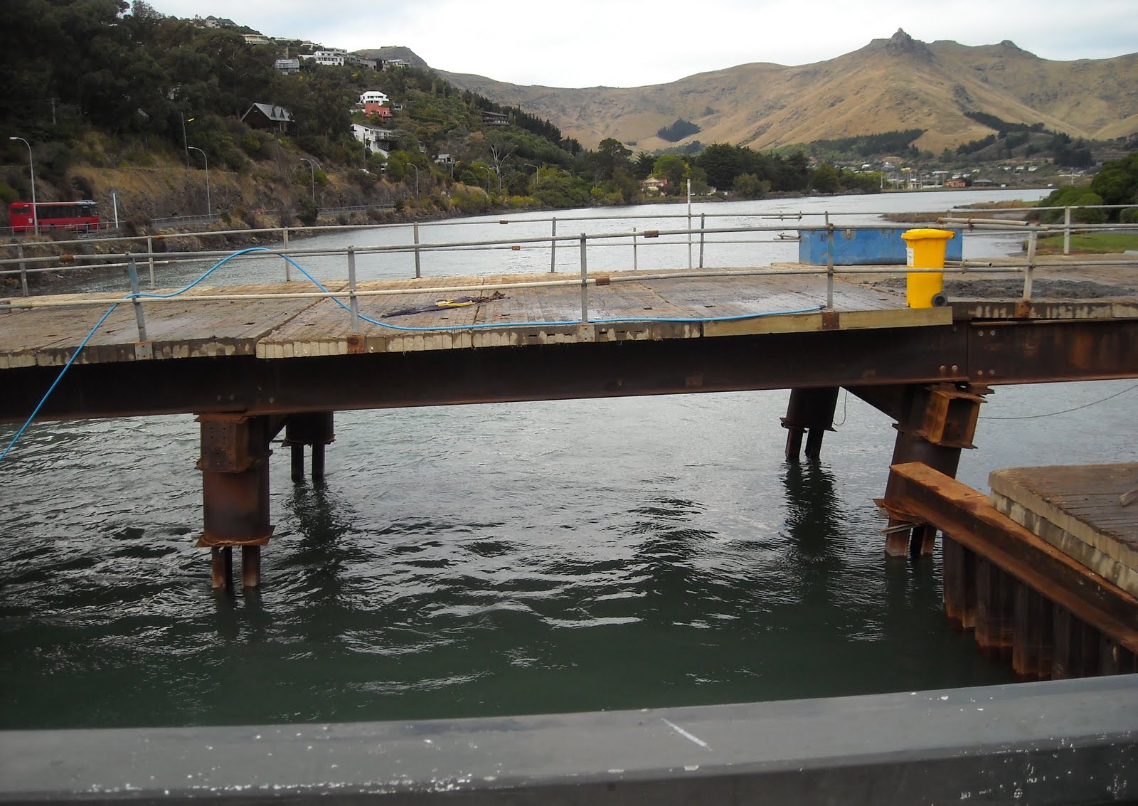
Ferrymead Bridge: Near three cranes, workmen in orange, Hi-Vis vests scurried around, directing congested traffic over the bridge, orange-plastic-road-cones everywhere. Steel & wood pre-quake bridge-extensions, with quake-tilted steel-columns in Heathcote Estuary water. Driveways, road & footpaths were cracked & broken, both sides of Ferrymead Bridge. Concrete-curbs were pulled from footpaths. Road-island bricks were scattered.

23.03.11. Feb 22 quake damaged Main Rd, Ferrymead Bridge, national state of emergency

23.03.11. Orange, plastic, road cone cordon. Feb 22 quake damaged road island, Main Rd by Ferrymead Bridge, national state of emergency

23.03.11. Feb 22 quake damaged pavement, Ferrymead Bridge, national state of emergency


23.03.11. Yellow crane extending Ferrymead Bridge, Avon / Heathcote Estuary, national state of emergency
Workmen's spray-painted messages on footpaths:
T/COM
8 DUCTS
FIBRE

PLEASE
STAY IN THE
MIDDLE & CROSS
AS FAST AS POSSIBLE


23.03.11. Feb 22 quake damaged Ferrymead Bridge view of bridge extension & Ferrymead Tce, Heathcote Estuary, Ferry Rd, national state of emergency

23.03.11. Ferrymead Bridge view, portaloo truck going to Redcliffs & Sumner, national state of emergency

23.03.11. Feb 22 quake damaged Ferrymead Bridge extensions, Heathcote Estuary, national state of emergency


Main Rd: USAR/ TF had pink spray-painted on a garden-wall: CLEAR NO GO. CLEAR or C meant no bodies. That CLEAR NO GO ambiguity was how we lived in Christchurch post 22 February 2011 quake. For example: Hamilton, CD boss, during the National State-of-Emergency, retired military helicopter pilot, gave CBD business-owners a hard time: causing them to protest, pleading entry to the NO GO, CBD red-zone, to gather business-records & chattels. Power-mongering by Hamilton was for citizens' safety: garrotte-cordoning of Christchurch-CBD, intimidating NZDF-soldiers & cops & demolishing buildings, during the National State-of-Emergency. Post Hamilton, power-mongering would worsen, when CERA, the new National government department occupied Christchurch-CBD & meddled in Council affairs.
October 2012, long after Hamilton left, 20 months post 22 February 2011 quake, public would still be forbidden access to Christchurch NO GO, CBD red-zone. During CERA's regime, unelected, National party, yes-men, like CERA boss Sutton & sockpuppet, CCDU boss Isaacs would occupy Christchurch-CBD, their fiefdom. During CERA's regime, mayor Parker & councillors would be puppets on sinecures.

23.03.01. Blue portaloos, Ferrymead Tce / Main Rd, national state of emergency

23.03.11. Feb 22 quake cracked curb & pavement, St Andrews Hill turnoff, Main Rd, national state of emergency

23.03.11. Three cranes, Ferrymead Bridge, Ferrymead Tce / Main Rd crossing, national state of emergency

23.03.10. CLEAR NO GO wall sign, Ferrymead, Main Rd, national state of emergency. CLEAR meant no bodies

23.03.11. Liquefactioned driveway, Main Rd, national state of emergency

23.03.11. Feb 22 quake damaged pavement, Main Rd, national state of emergency

Pity citizens' safety wasn't covered pre 22 February 2011 quake, with all those ruins ready to topple after Council's green-stickers, yellow-stickers & red-stickers post 4 September 2010 quake. How many green-stickered & yellow-stickered, brick-buildings & stone-buildings collapsed in the 22 February 2011 quake & were quickly demolished during the National State-of-Emergency? Nice to have one's inspection- mistakes sealed behind a National State-of-Emergency cordon, protected by NZDF-soldiers & cops, then a CERA-cordon, protected by NZDF- soldiers & cops for 28 months, public banned access to the NO GO, CBD red-zone, on pain of arrest. Those mistakes would be buried & forgotten in Burwood demolition-dump.

23.03.11. Blue truck, temp dumping Feb 22 quake damaged asphalt in carpark, Avon Heathcote estuary, Main Rd, national state of emergency

23.03.11. Feb 22 quake cracks, gulls, pied oystercatchers, Mt Pleasant Yacht Club carpark, Main Rd, national state of emergency. The cracks were caused by lateral spreading. The apartment block would be demolished
Main Rd: Lateral-spreading caused slumping & cracking of Mt Pleasant Yacht Club carpark at the estuary-edge. Gulls & pied oystercatchers didn't mind.

23.03.11. Orange, plastic, road cone cordon. Feb 22 quake cracked McCormacks Bay causeway, one-way due to road repairs, Main Rd, national state of emergency
Main Rd, McCormacks Bay Causeway: One-way traffic to Redcliffs over the causeway. Town traffic was detoured along bumpy McCormacks Bay Rd. Uneven surface on the causeway was due to quake-damage & lateral-spreading, repairs needed. Parallel-cracks on the road-shoulder all along the causeway were due to lateral-spreading. Causeway end: Road-island bricks were scattered. Blue-portaloo on footpath by two-storey flats, orange-plastic-fence-cordoned.
Fifteen months post 22 February 2011 quake, the causeway would still be one of the worst roads in Christchurch, lumpy, bumpy & patched. 30 months post 22 February 2011 quake, the causeway would still be closed, undergoing repairs, traffic detoured along bumpy McCormacks Bay Rd.

23.03.11. Blue portaloo, Main Rd / McCormacks Bay Rd, national state of emergency

23.03.11. Feb 22 quake rock fall, Main Rd / McCormacks Bay Rd, national state of emergency

23.03.11. Feb 22 quake damaged road island, end of McCormacks Bay causeway, Main Rd, national state of emergency
Main Rd / Beachville Rd by Avon / Heathcote estuary: Broken garden-wall. Rockfall on footpath, fallen-rocks from a cliff-top house between Main Rd & Beachville Rd, orange-plastic-road-cone-cordoned.

23.03.11. Orange, plastic, road cone cordon. Feb 22 quake rock fall, Beachville Rd, national state of emergency


Redcliffs cliff top housing: Damaged, Feb 22 Killer Quake. Would be more damaged, June 13 Quake.


23.03.11. Redcliffs Park view, Feb 22 quake, Redcliff rock falls, Beachville Rd, national state of emergency. Years later, after a new school was built, Redcliffs School would relocate to the park site


23.03.11. Shags, Avon / Heathcote Estuary, Beachville Rd carpark, national state of emergency

23.03.11. Gulls & pied oystercatchers, Feb 22 quake cracked Beachville Rd carpark, national state of emergency. Quake cracks were caused by lateral spreading

23.03.11. Jetty shags, Beachville Rd boat ramp, national state of emergency
Beachville Rd carpark: Cracks caused by lateral-spreading. Gulls & pied oystercatchers roosted by estuary rocks & quake-cracks. Grand views of "new" Redcliffs from Redcliffs Park. A row of shags perched on the wooden-jetty by a boat-ramp. High-tide views across Avon / Heathcote Estuary belied quake-destruction, needing repairs.
See below: Post-quakes, Redcliffs Park would become the site for relocated, rebuilt Redcliffs School.

23.03.11. Green portaloo, Beachville Rd, national state of emergency
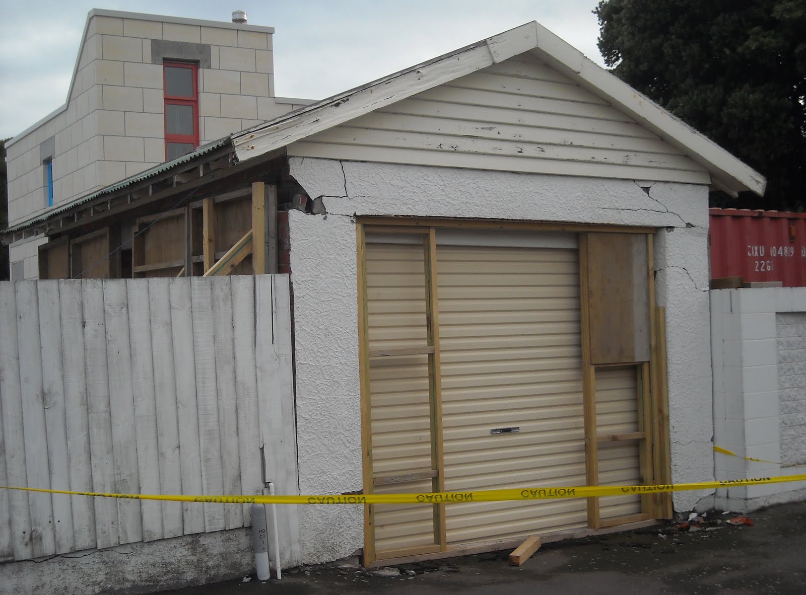
23.03.11. Yellow, plastic, tape cordon. Feb 22 quake trashed garage, Beachville Rd, national state of emergency

23.03.11. Grey / green portaloos opp linesman fixing power, Beachville Rd, national state of emergency
Beachville Rd: Portaloos on footpath. Road lumpy, bumpy & potholed. Fallen garage-wall, yellow-plastic-barrier-tape-cordoned. Wearing Hi-Vis vests, Drain Rat workmen sucked sewage into a tanker in the middle of the road. The road-corner was cracked & lumpy by the concrete sea-wall. The corner house was tilted towards estuary water. Grass verges & footpath were cracked near the sea-wall, due to lateral-spreading. An old, white Mercedes: front wheel trapped in a carpark road-crack. Cracks continued parallel to the 500m long sea-wall, which was tilted its entire length toward Avon / Heathcote Estuary. The 22 February 2011 quake took a few seconds to seawards-shift the entire, half kilometer long concrete-wall. It was about half a metre wide, four metres high.

23.03.11. Orange, plastic, road cone cordon. Post Feb 22 quake, Hi-Vis vested workmen fixing Beachville Rd, national state of emergency

23.03.11. Orange portaloo & Feb 22 quake cracked garden wall, Beachville Rd, national state of emergency

23.03.11. Feb 22 quake shifted, tilted, concrete, sea wall & slumped, cracked Avon / Heathcote Estuary shore, Beachville Rd, national state of emergency. Slumping & cracks, due to lateral spreading


23.03.11. Feb 22 quake Warning Contaminated Water sign & Mercedes trapped in carpark, quake crack, Beachville Rd, national state of emergency


23.03.11. Feb 22 quake tilted, concrete, sea wall, Avon / Heathcote Estuary, Beachville Rd, national state of emergency. Tilting & cracks, due to lateral spreading


23.03.11. Feb 22 quake broken, concrete sea wall, Avon / Heathcote Estuary, later sandbagged, Beachville Rd, national state of emergency

23.03.11. Blue & orange portaloos & liquefaction silt, Beachville Rd, national state of emergency
20.12.12 Twenty one months later, I would return to Beachville Rd's concrete sea-wall. No repairs were done, cracks still in the sea-wall & a big gap was still there. Lateral-spreading & deep cracks by the roadside were still there. Meanwhile, the northern end of the 500m long sea- wall had sunk deeper into estuary mud, so a shingle-stopbank would be built as flood-protection.

20.12.12. Quake tilted, concrete, sea wall, Avon / Heathcote Estuary, 22 months post 22.02.11 quake, Beachville Rd. Lateral spread, quake cracks had been partly infilled

20.12.12. Quake cracked, concrete, sea wall, Avon / Heathcote Estuary, Beachville Rd
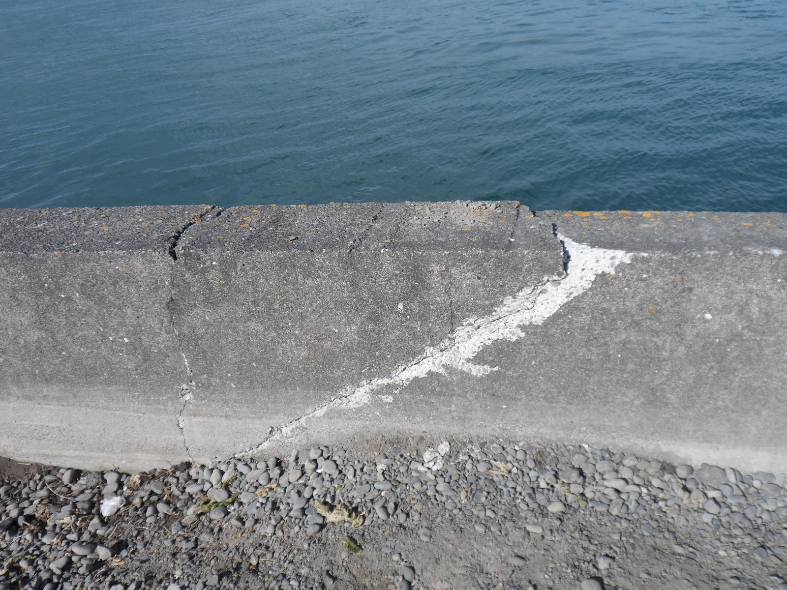


20.02.12. Quake tilting & slumping of concrete, sea wall, Avon / Heathcote Estuary, Beachville Rd. Slumping was due to lateral spreading


20.12.12. Stopbank by quake sunken, concrete, sea wall, to stop flooding, Avon / Heathcote Estuary, Beachville Rd


Only in August 2015 would SCIRT begin replacing Beachville Rd sea-wall with a rock-revetment. Replacing the sea-wall work would continue till December 2016.

Main Rd: I parked my car opposite quakemired New World supermarket ghost. I looked at the community INFO caravan & all the community adverts helping Redcliffs locals. Post 2011 quakes, Redcliffs New World building would be demolished & rebuilt.

23.03.11. Feb 22 quake, Cronos water tank by BP garage, Main Rd, Redcliffs, national state of emergency

23.03.11. Feb 22 quake rock falls by Redcliffs School, Main Rd, national state of emergency


23.03.11. Feb 22 quake rock falls by Redcliffs housing, Main Rd, national state of emergency


23.03.11. DANGER KEEP OUT. White, plastic, tape cordoned driveway. Feb 22 quake, rock fall damaged house, Main Rd, national state of emergency

23.03.11. Feb 22 quake damaged, yellow, adobe house & cliff top house near Moa Bone Point Cave, Main Rd, national state of emergency. Both houses would be demolished

23.03.11. Feb 22 quake, rock fall damaged, yellow, adobe house, Main Rd, national state of emergency. The adobe house would be demolished


23.03.11. Feb 22 quake damaged house, Main Rd, Redcliffs, national state of emergency

Main Rd: I trekked to Moa Bone Point Cave, past open BP garage, a Cronos water-tank alongside, past Redcliffs School, open for the first time since the 22 February 2011 quake. (Redcliffs School would later be closed, sharing premises with Van Asch Deaf Education Centre, Sumner. After years of protests with MoE about rockfall dangers on school grounds, Redcliffs School would be rebuilt on nearby Redcliffs Park. Redcliffs Park flooded in heavy rains, close to Avon Heathcote Estuary)! I trekked past ruined housing: loosened roof-tiles, cracked-walls, collapsed-walls, tilted-walls, fallen cliff-rocks in gardens & rock-crushed walls.
I saw Redcliffs rockfalls & damaged Moa Bone Point Cave, rock-roof fallen, rocks on footpath, steel-mesh-fence-cordoned. A three-storey, yellow, adobe ruined-house below a cliff: third-floor side-wall was crushed by fallen rocks, room-exposed. The yellow, adobe ruin & a cliff- top ruin above would be demolished. Who built & bought houses atop cliffs & at the bottom of cliffs?
Post 22 February 2011 quake, concrete-block barricades would stop cliff-rocks rolling onto Main Rd. Post 13 June 2011 quake, a two-storey row of shipping-containers in front of Moa Bone Point Cave would protect traffic from rockfall & house-fall for years.

23.03.11. Concrete road barriers. Feb 22 quake rock fall near Moa Bone Point Cave, Main Rd, national state of emergency

23.03.11. Feb 22 quake damaged, cliff top house, above Moa Bone Point Cave, Main Rd, national state of emergency. The house would be demolished in 2013


23.03.11. Steel mesh fence cordon. Feb 22 quake rock fall, Moa Bone Point Cave, Main Rd, national state of emergency. Post 13.06.11 quake, the cave would be cordoned by shipping containers


Main Rd: Two-storey, ghost-house, fallen brick-walls, fallen stone retaining-wall, red-plastic-barrier-taped, orange-plastic-road-cone-cordoned. Damaged old, brick bus-stop, a ghost-building, walls cracked, walls tilted, garage-door tilted, slumped. Tarseal carpark: snapped wooden power-pole lying on carpark. USAR / TF spray-painted graffiti on broken-walls: DANGER KEEP OUT. Along that stretch of Main Rd I saw many rockfalls behind houses below cliffs, many rock sizes with rock-fans below Redcliffs. Would Redcliffs upmarket house prices slump after all that rockfall?

23.03.11. Red, plastic tape & orange, plastic, road cone cordon. Feb 22 quake damaged house near Moa Bone Point Cave, Main Rd, national state of emergency

23.03.11. Feb 22 quake snapped power pole, Main Rd, national state of emergency

23.03.11. DANGER KEEP OUT. Feb 22 quake damaged, bus stop bldg, near Moa Bone Point Cave, Main Rd, national state of emergency


23.03.11. Feb 22 quake rock fall, Main Rd / Beachville Rd, national state of emergency
Main Rd: Broken at Cave Tce near damaged Moncks Cave. Demolition-rubble was dumped at Moncks Cave mouth near a cave rockfall. Portaloo on Cave Tce footpath. Fifteen months later, Moncks Cave would still be a rubble-dump.

23.03.11. Orange, plastic, road cone cordon & orange, plastic, road barrier detour, Feb 22 quake damaged Main Rd by liquefactioned New World, Redcliffs, national state of emergency. New World would be demolished & rebuilt

23.03.11 Blue portaloo, Main Rd / Moncks Spur Rd, national state of emergency

23.03.11. Feb 22 quake demolition rubble, Moncks Cave, Main Rd, national state of emergency
Avon / Heathcote Estuary mouth: Shag Rock was shattered by the 22 February 2011 quake, about half its pre-quake size. Shag Rock would collapse more during the 13 June 2011 quake, leaving a stump 0f fallen rocks.

23.03.11. Feb 22 quake shattered Shag Rock, Marriner St, national state of emergency


Main Rd / Marriner St: Clifton sea cliff opposite Shag Rock & Avon / Heathcote Estuary mouth: Two layers of 22 shipping- containers lined the cliff-base, protecting traffic from aftershock rock-falls. Later the stacked shipping-containers would be extended along Peacocks Gallop, Marriner St, below Clifton, all the way to Gollans Point, Sumner. The protective cordon of shipping- containers would stand below Clifton for years. Post-quakes, cliff-top, ghost-houses would be demolished, the cliff above the road corner opposite Shag Rock would be reduced in volume by drilling & blasting to prevent future rockfalls endangering traffic by Avon / Heathcote Estuary mouth.

23.03.11. Stacked shipping containers, orange, plastic, road cones cordoning Feb 22 quake rock falls, Main Rd / Marriner St, national state of emergency


Clifton sea cliff: Several rockfalls below the cliff, forming rock-fans, which crushed vegetation: broken shrubs were flattened by rockfalls at the cliff-base. I watched a workman on the cliff-top water-blast garden rubbish, which tumbled down the 60m cliff. Three cops & a Fulton Hogan sign truck kept a wary eye on the water-blaster.
Marriner St, Peacocks Gallop: Scary due to rockfall danger. Locals drove past daily.


23.03.11. Feb 22 quake rock fall, Clifton sea cliff, Peacocks Gallop, Marriner St, national state of emergency. New rock fan & abandoned cliff top housing


23.03.13. Feb 22 quake, rock fall crushed vegetation, Peacocks Gallop, Marriner St, national state of emergency


Marriner St, Gollans Point: Another rockfall from Clifton sea-cliff, fallen rocks by a small cave. Roadside shrubs cleared by workmen.

23.03.11. Feb 22 quake rockfalls, Gollans Point, Marriner St, national state of emergency. Later the road would be protected by a double layered, shipping container cordon

Esplanade: Sumner traffic detoured by Cave Rock. Old two-storey, brick ghost-house: fallen side-walls, damaged roof-slates, brick-rubble on carpark, white-plastic-barrier-tape-cordoned. The house would be demolished.

23.03.11. White, plastic, tape cordon. Feb 22 quake damaged house, Esplanade, national state of emergency. The house would be demolished


Wakefield Ave: Demolished Ruptured Duck restaurant, damaged by the 4 September 2010 quake, ruined by 22 February 2011 quake. A rubble- heap, steel-mesh-fence-cordoned. Cordon fence-sign:
DE-STRESS
WITH FREE
OUTDOOR WORKOUTS
FITNESS...

23.03.11. Steel mesh fence cordon. Demolished Ruptured Duck restaurant, Wakefield Ave, national state of emergency
Wakefield Ave / Nayland St: Sumner Community Centre ghost (old brick-building, 1907, Sumner Borough Council). Cracked front-facade brick- wall, cracked brick-gable, cracked brick-parapet, broken-windows above a door, cordoned by shipping-containers, steel-mesh-fence-cordoned, orange-plastic-road-coned. Sumner Community Centre would be demolished post 13 June 2011 quake & replaced by a small park & skateboard ramp.
Cosi Van Tutte shop: Red-stickered glass-door. Boarded-door. Broken window-glass on footpath. Fish 'n Chips shop: A grizzled man read a newspaper at an outside table by a fallen brick-wall. Across Wakefield Ave, Sumner cliff loomed: collapsible.

23.03.11. Man reading at cafe table by Feb 22 quake fallen brick wall, Wakefield Ave, national state of emergency
Fish 'n Chips shop window, hand-written notice:
HOT SHOWERS
AT
SUMNER COMMUNITY POOL
CHANGING ROOMS
9 am - 7 pm
2 MINS MAX PLEASE
NOTE: POOL CLOSED FOR
SWIMMING

23.03.11. Feb 22 quake notice, Wakefield Ave, national state of emergency
Also on the Fish 'n Chip shop window, a CHRISTCHURCH EARTHQUAKE RESPONSE, blue / white printed notice listed COMMUNITY BRIEFINGS:
CHRISTCHURCH [Council]
EARTHQUAKE RESPONSE
COMMUNITY BRIEFINGS [Shortened, times & streets not included].
You are invited to attend one of the following community earthquake information briefings:
Monday 21 March Bromley Park, Linwood
Woolston Park
Tuesday 22 March Richmond Park
St Albans Park
Wednesday 23 March South Hagley Park, Cricket Ground
Somerfield Park
Oaklands School, Halswell
Thursday 24 March Waltham Park
Lyttelton, grassy area above Main School
Friday 25 March Redcliffs, Barnett Park
Sumner School grounds
Saturday 26 March Brooklands Domain
Parklands Reserve
Rawhiti Domain, next to cricket oval
South Brighton Park, aka Jellico Park
*Hear the latest news followed by the chance to ask questions one-on-one.
*The briefing closest to you will be the most useful for you, however there will be relevant information at all of the briefings.
*These are open-air briefings so dress for the weather and bring a seat.
*There may not be toilet facilities at the briefings.
Visit www...

23.03.11. CHRISTCHURCH EARTHQUAKE RESPONSE notice, Wakefield Ave, national state of emergency
The 22 February 2011 quake ruined Sumner's water supply, so washing & cleaning was difficult. Unpolluted drinking-water had to be collected from roadside, Cronos water-tanks. Sewage-pipes were also trashed, making toileting difficult, hence many portaloos on Sumner roadsides. Soon all Council Earthquake Responses would be usurped by CERA.


23.03.11. Feb 22 quake, boarded, red stickered, Cosi Fan Tutte shop, Wakefield Ave, national state of emergency

23.03.11. Orange, plastic, road cone cordon. Feb 22 quake rock fall, Wakefield Ave, national state of emergency
Wakefield Ave / Nayland St: By Sumner cliff rockfall, Marine Service Station, hand-written sign:
WE ARE OPEN AND
OPERATING FROM TEMP
PREMISES. PLEASE PH...
After 2010-2011 quake-damages, many business-owners had to relocate, continue business, or go bust. When we'd lived at Sumner in 1995, our car was serviced at Marine Service Station.


23.03.11. Feb 22 quake rock fall, RSA bldgs, Wakefield Ave, national state of emergency
Wakefield Ave: RSA building was ruined by a house-sized rock, fallen from Sumner cliff. Crumpled, corrugated-iron-roof, fallen brick-wall, exposing roof-space & rooms. House-sized rock, brick-rubble & stone-rubble between RSA buildings & on footpath. Ghost- carpark stone-wall crunched by fallen rocks. Rock-crushed brick-wall sign:
SUMNER REDCLIFFS
RETURNED SERVICES
ASSOCIATION
Alongside RSA, a new flats development: wooden-wall supports crushed by rockfall, planks & rocks scattered on the building-site, steel-mesh- fence-cordoned. (Silver Star Developments Ltd). Post 4 September 2010 quake, why did Council consent that development below Sumner cliff?

23.03.11. Feb 22 quake rock fall damage, RSA bldgs, Wakefield Ave, national state of emergency


On Wakefield Ave footpath, a pub chalk-board sign:
RE-OPEN
THURSDAY
5 PM
HAPPY HOUR
ALL NIGHT
Indeed!


23.03.11. Feb 22 quake rock fall, RSA bldgs, Wakefield Ave, national state of emergency


23.04.11. Steel mesh fence cordon. Sumner cliff, quake rock fall trashing of post Sept 4 quake, Silver Star Developments Ltd flats, next to rock fall trashed RSA, Wakefield Ave


RSA memorial gatepost plaque:
WE
HONOUR
OUR
FALLEN
COMRADES
Fallen comrades would be spinning in their graves at greedy Council consenters & greedy developers cashing in.


Wakefield Ave, Croquet Club ghost: Rockfall lay below Sumner cliff on the croquet lawn. When I returned an hour later, digger-tracks gouged the lawn. Rocks gone.

I trekked Sumner, detouring orange-plastic-road-cones. Most roads I drove had portaloos roadside, but most houses looked OK. Our old Denman St, two-storey rental looked undamaged, liquefaction-dust still on the road. A neighbour's brick gate-post was fallen. Cliff rockfall was at the end of Denman St by Wakefield Ave, a rockfall fan was below the cliff & on the footpath.

23.03.11. Feb 22 quake, Wakefield Ave rock fall, end of Denman St, national state of emergency

23.03.11. Orange portaloo, Denman St, national state of emergency

23.03.11. Feb 22 quake trashed, brick gatepost, Denman St, national state of emergency

23.03.11. Denman St house, undamaged by Feb 22 quake, national state of emergency
Colenso St, Sumner School: A Cronos water-tank roadside. Jake attended Sunmner School during our early Christchurch days, 1995.

Wakefield Ave / Duncan St: Boarded-cottages at abandoned & boarded Capt Thomas Courts. Residents were relocated. A large rock lay on the grass verge by a cottage, another bigger rock in a flowerbed by a front-door. The rocks were numbered with lurid, yellow spray-paint. I snapped number 18 near a cottage. Roof-tiles were damaged. "Danger from falling rocks" was written on red-stickered cottage-doors.
Eight shipping-containers lined Wakefield Ave below Richmond Hill cliffs, protecting cottages from aftershock rockfalls. Wakefield Ave, Capt Thomas Track, Council sign:
TRACK CLOSED
DUE TO
ROCKFALL HAZARD
13 June 2011 quake: There would be more Sumner rockfalls below Richmond Hill. Wakefield Ave would be cordoned with a double layer of shipping- containers, bordering ghost-houses & All Saints Anglican Church ghost below Sumner cliff. CERA would red-zone those cliff-bottom houses & the church for demolitions.
Heberden Ave: There were rockfalls & shipping-container-cordons below Scarborough Bluffs. I would return for snapping another day.


23.03.11. Red stickered, boarded, abandoned Capt Thomas Courts, Wakefield Ave, national state of emergency. Numbered rock, fallen from Richmond Hill
Campbell St: Fallen brick gate-post on the footpath near a blue-portaloo.

23.03.11. Rubbish bins, blue & grey portaloos & Feb 22 quake fallen, brick, gate post, Campbell St, national state of emergency

Wakefield Ave: Fallen concrete brick, garden wall, bricks on pavement.
Van Asch St: At Van Asch Deaf Education Centre gate, a new, brick gate-post was undamaged by the quake. A Lime-green-portaloo at the gate.

23.03.11. Lime green portaloo, Van Asch Deaf Education Centre gate, Van Asch St, national state of emergency
Nayland St: Broken stone-walls, stones on footpath. Old damaged-houses: 1. Cliff-top, two-storey house, outer walls OK, but I saw fallen ceiling through unbroken glass-doors. Glass-windows, unbroken. Fallen cliff-rocks crushed a stone garden-wall, stones on footpath. Broken stone gate-post, stones in open garage. 2. Garage, fallen corrugated-iron. Fallen stone garden-wall, stones on footpath, white-plastic-barrier-taped, orange-plastic-road-cone-cordoned. 3. Fallen brick & fallen concrete-brick garage-wall & fallen stone garden-wall, bricks & stones on footpath, white-plastic-barrier-tape-cordoned.
Nayland St / Main Rd crossing: Broken-road.

23.03.11. Red, plastic tape, orange, plastic, road cone cordon. Fish 'n Chips shop view, Sumner cliff rock fall, Wakefield Ave / Nayland St, national state of emergency


23.03.11. Feb 22 quake trashed stone wall, Nayland St, national state of emergency


23.03.11. Feb 22 quake, Sumner cliff rock fall, Nayland St, national state of emergency. Abandoned cliff top housing

23.03.11. Fallen stone, garden wall. Feb 22 quake damaged house, Nayland St, national state of emergency


23.03.11. Blue portaloo, Feb 22 quake, new Sumner cliff face, due to rock fall, Nayland St / The Zig Zag, national state of emergency

23.03.11. White, plastic, tape cordon. Feb 22 quake damaged brick wall, Nayland St, national state of emergency
Clifton Bay: Four greystone garden-walls were collapsed in front of four wooden, two-storey houses, fallen greystones on footpath. I saw telescopes in two top-storey windows for Pacific shipping views & Sumner beach bikini views across the road.
Oct 2012. More than a year later, the greystone walls were still unrepaired, awaiting insurance payouts.

23.03.11. Feb 22 trashed, greystone, garden walls, Clifton Bay, Sumner, national state of emergency


I returned to Burnside along McCormacks Bay Rd, a one-way detour: broken, lumpy & bumpy. I drove past the liquefactioned rugby-field, grass verges & McCormacks Bay Reserve, where a quakemired-creek entered McCormacks Bay. Small rockfalls roadside, some road-repairs done.
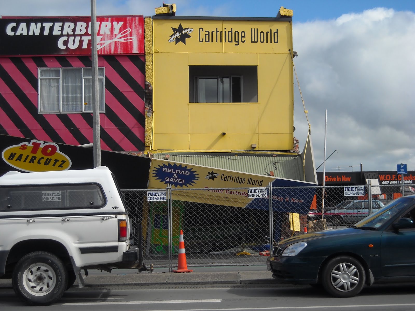
Linwood Ave / Aldwins Rd, en route home :22 February 2011 quake destroyed, two-storey, brick-walled ghost-shops: Fallen brick-parapets. Collapsed coner shop, Herbal Heaven, a brick-wall leant over Aldwins Rd, the lower-storey crushed by weight of the tilted upper- storey, steel-mesh-fence-cordoned. Next-door shops: Sunlake Dairy, Brewing Distilling, Left Hand Path Tattoos, Canterbury Cutz verandah, crumpled & part-collapsed. At shops' end, Cartridge World: fallen brick side-wall, exposed upper passage & inner wooden-wall, brick-rubble in carpark, steel-mesh-fence-cordoned.
The shops would soon be demolished. (Burger King rebuild). I'd driven Luke to Sullivan Ave tech past those shops during pre-quakes 2010. Post 22 February 2011 quake, some days, I would drive the long way round from Burnside to Sullivan Ave tech, along the freeway & Brougham St.

23.03.11. Steel mesh fence cordon. Feb 22 quake trashed shops, soon demolished (Burger King rebuild) Aldwins Rd / Linwood Ave, national state of emergency


Linwood Ave / Cashel St: Shell garage, steel mesh fence cordoned, closed post Feb 22 Killer Quake, quakemire stuffed into sinkholes on the concrete apron.

23.03.11. Feb 22 liquefactioned, closed, Shell garage, Linwood Ave, national state of emergency
Linwood Ave / Worcester St: Old, brick, ruined-shops, corrugated-iron-roof intact, but fallen brick-parapet, fallen brick-wall exposed roof-space & inner wooden-wall, brick-rubble on footpath, verandah-roof part-collapsed onto footpath, steel-mesh-fence-cordoned. After rains, ruins had a mouldy, woody smell. Shop-door, hand-written sign:
ALL OUT & OK
CLOSED TO
RELOCATE

23.03.11. Steel mesh fence cordon. Feb 22 quake trashed, old, brick bldg, Linwood Ave / Worcester St, national state of emergency. 2019: The bldg survived the quakes, but stayed boarded for years.


Linwood Ave / Gloucester St: St George's & Iona Presbyterian demolition-site. Another old church gone. Like so many old, brick & stone buildings, old churches had poor quake-strengthening.

23.03.11. Orange, plastic, road cones, steel mesh fence cordon. Demolished St George's & Iona Presbyterian Church, Linwood Ave / Gloucester St, national state of emergency
Linwood Ave / Avonside Dr / Woodham Rd crossing, by an Avon River bend: ROAD CLOSED. Burst water-pipes during the 4 September 2010 quake left the crossing badly damaged. Post 22 February 2011 quake the crossing was worse: Road-cracks, quakemired-road. Snapped concrete-curb. Brick garden-wall collapsed onto cracked-footpath. Three tankers sucked muck from road-holes. A yellow digger added to the mess. Orange-plastic-road-coned. Steel-mesh-fence-cordoned. Five Hi-Vis vested workmen watched one workman in a liquefaction-hole. Shirking workmen again, most standing around, like other workmen around town, wary of me snapping, yelling snarky remarks. Given their productivity, Christchurch recovery would take many years. That crossing would finally be fixed by October 2012. Only after CERA eventuated would productivity speed up, after Irish & Philippino workmen arrived.
Council signs: Red, black, white, WARNING WATER CONTAMINATED threat-sign hung on a riverbank tree. Blue, black, white sign forbade non residents along Avonside Dr, cordoned by orange-plastic-road-cones. Soon we'd endure many CERA printed signs.

23.03.11. Hi-Vis vested, road workmen repairing Avonside Dr / Woodham Rd / Linwood Ave crossing, trashed in Sept 4 & Feb 22 quakes, national state of emergency


23.03.11. Orange, plastic, road cones, steel mesh fence cordons. Blue, non residents forbidden sign, Sept 4 & Feb 22 quake trashed Avonside Dr / Woodham Rd crossing, national state of emergency

23.03.11. Orange, plastic, road cone cordon. Post Feb 22 quake tanker sucking muck from Avonside Dr / Linwood Ave crossing, national state of emergency

23.03.11. Feb 22 quake snapped, concrete curb, Avonside Dr / Woodham Rd, national state of emergency

23.03.11. Warning Water Contaminated sign, Avon River, Avonside Dr / Woodham Rd, national state of emergency

23.03.11. Sept 4 quake damaged, Feb 22 quake trashed garden walls & curb, Avonside Dr / Woodham Rd, national state of emergency


23.03.11. Orange, plastic, road cone cordon. Feb 22 quake, road pipe repairs & muck sucking, Linwood Ave / Avonside Dr, national state of emergency

23.03.11. Hi-Vis vested, road workmen productivity, 5 shirking, 1 working, Avonside Dr / Linwood Ave
Stanmore Rd / Worcester St: 22 February 2011 quake ruined, one-storey & two-storey, brick-shops, steel-mesh-fence-cordoned, Stanmore Rd. Corner shop, fallen parapet, fallen verandah awning, exposed roof-space. Brick-rubble on footpath, steel-mesh-fence-cordoned.
Worcester St: Red-stickered, $4 ghost-shop, a two-storey ruin. Brick-gable & side brick-walls fallen onto neighbouring one-storey shops, Wicks Fish & Lakes Chemist. Roof-space exposed. Red / yellow tarp hanging loose on front-facade. Windows broken. Clothes on shop hanger- trolley exposed on footpath. Verandah-roof was collapsed by fallen-bricks. Brick-rubble on footpath, steel-mesh-fence-cordoned. TF1 CLEAR 26/2 yellow spay-painted on a glass-door.
Lakes Chemist ruin: Roof collapsed from bricks fallen from next door two-storey, $4 shop. Roof-space exposed. TF1 CLEAR 26/2 yellow spray-painted on a grey-board covering the facade. Bricks on footpath, steel-mesh-fence-cordoned.
Wicks Fish ruin: Roof collapsed into shop by bricks fallen from next-door two-storey, $4 shop. Two people killed in the 22 February 2011 quake. Broken display-window. Brick rubble on footpath. Flower bouquets drying on the steel-mesh-fence-cordon.
Hibbards Butchery ruin: Brick-gable gone. Brick-rubble on footpath, steel-mesh-fence-cordoned.
Talon Arms ruin: Wooden building. GUNS GONE, grey spray-painted on board covering shop-front. CLEAR 06/03/11 TF1 yellow spray-painted on board. Brick-rubble on footpath. Wooden Talon Arms would be the only shop in the vicinity to survive the quakes. All neighbouring brick-shops would be demolished.


23.03.11. Steel mesh fence cordon. Sept 4 quake damaged, Feb 22 quake trashed old, brick bldgs (to be demolished) Worcester St, national state of emergency. Two people were killed at Wicks Fish left


23.03.11. Feb 22 quake, flowers on steel mesh fence cordon honouring 2 quake dead, Wicks Fish, Worcester St, national state of emergency. Brick wall of $2 shop next door collapsed into Wicks Fish


23.03.11. Feb 22 quake damaged, Talon Arms, Worcester St, was not demolished, national state of emergency. USAR / TF graffiti CLEAR meant no bodies
London St: Quakemire-volcano on the footpath outside Leah's classroom was gone, dug away by prisoners. Prisoners dug mud away from the nearby Village Green too. Leah thanked them.
Thurs 24.03.11. One News TV featured engineers & a breathless reporter clambering the Port Hills above Avoca Valley, rolling unstable rocks downhill, blowing up rocks too big to roll. Reason: danger to people & buildings in orchard strewn Avoca Valley.
*Trekked Richardson Tce, Ferry Rd, Main Rd, Beachville Rd, Marriner St, Esplanade, Wakefield Ave, Nayland St, Clifton Bay, Linwood Ave, Avonside Dr, Stanmore Rd, Worcester St, London St. 271 snaps.
Coda:
In future, rockfalls would be a contentious, residential zoning issue between Council, CERA & home-owners: Council red-stickered perfectly good Port Hills housing & CERA red-zoned Port Hills housing. Residents objected to CERA's slow zoning & how / why their homes were red-zoned. There would be issues of rolling-rocks, bouncing-rocks, rockfalls, slips, foreign university computer-modelling, berms, catcher-fences, compacted-rock-structures, trees to protect housing from rockfalls.
Sun 14.02.16. Valentines Day Quake, M5.7. Rockfalls at Godley Head, Sumner's Richmond Hill & Peacocks Gallop.
Content & pics Copyright Mark JS Esslemont.
See Redcliffs School Closure Decision (The Press / Stuff Co).
Gave permission for an author to publish my Cob Cottage pic in a Lyttelton Harbour jetties book, incl Henderson family info.
ReplyDelete